history and memory
In the southern part at the closure of the walls there is a large portal crowned by a lowered stone arch, which creates a wide access passage, and by battlements that bear traces of a drawbridge, which can be lifted in a vertical position through the system of beams given the deep grooves and pontoon holes present. From the wall texture made of stone blocks of various sizes it is clear that both the portal and the polygonal tower date back to the rest of the buildings and the original layout of the fortification as they are made with small square stones.
Castle and rural lordships
Giovanna Benni, researcher and teacher from Umberto I in 2002 carried out a study on “Castle and rural lordships in the Upper Tiber valley between the Early and Late Middle Ages. The territory of Umbertide (Perugia, Italy) ". Work published in NOTEBOOKS ON MEDIEVAL TOPOGRAPHY (Documentary and field research) Edited by Stefano Del Lungo N. 7, 2006.
We propose a reworked summary of her work, with several photos of the settlements made by Giovanna at the time, but without the more scientific apparatus, that is the references of the notes and bibliographical references in compliance with the edited publication.
The aim of this research was aimed at strengthening the hypotheses of an early embedding in the high-tiber area.
Giovanna used the archaeological and documentary data about the historical territory corresponding substantially to the Municipality of Umbertide, to highlight the settlement processes of the castle and the settlements on the tops of the hills and mountains during the sixth and eighth centuries AD. C ..
Investigation that used materials, historical-literary sources and documents (archival and non-archival): maps, plans, plans and topographical maps were evaluated to reconstruct the existence of the sites, their toponymic persistence, in cases of disappearance of the inhabited areas , or their transformation today.
Thirty sites have been identified, the development of which took place in different chronological moments between the Early and Late Middle Ages in the complex process of fortification; the analysis of these sites includes various types, classified as towers with a main defensive purpose, castra (which combined defensive needs and economic organization, with the main demic aspect, or rather of population) and villae, in which the demic character is predominant, failing that of fortification elements.
In fact, in the chapter "Lines of research for a repertoire of fortified settlements" he indicates these sites:
1 - Rasina (castrum Rasine)
2 - Monte Castelli (Mons Castelli, Montis Castelli)
3 - Montemigiano (Monte Mixano)
4 - Verna (castrum de Verna)
5 - Migianella dei Marchesi (castrum Megiane Marchionum, castrum Megiane Marchionis)
6 - Civitella dei Marchesi and Sant'Anna (Civitella Guasta)
7 - Bastia Creti (Bastia Crete, Bastia di Croce)
8 - Pieve di Cicaleto (villa Plebis Cicaleti, villa Plebis Cecaleti, villa Plebis Cicalleti)
9 - Montalto (castrum Mons Altus, castrum Montis Alti)
10 - Certalto (castrum Certalti)
11 - Serra Partucci (castrum Serre, Serre Comitum, Serre super Assinum, Serre Partucci, castrum Serre Partutii)
12 - Civitella Ranieri (castrum Civitelle Comitum, Civitella Comitum)
13– Umbertide (castrum Fracte filiorum Uberti)
14 - Poggio Manente (castrum Podio Manentis)
15 - San Paterniano (S. Patrignani, vila S. Patrignani supra S. Iohannem de Asino, S. Paterniani)
16 - Polgeto (villa Pulgeti)
17 - Castiglione dell'Abbate (castrum Castiglionis Abbatis, castrum Castilionis Abbatis)
18 - Sportacciano (villa Sportaçane, villa Sportaçani, villa Sportazani, villa Sportaciani)
19 - Santa Giuliana (castrum Sancti Iuliani, castrum Sancte Iuliane)
20 - San Giuliano delle Pignatte (villa S. Iuliani, Sancti Iuliani de Collinis, vila S. Iuliani)
21 - Fratticiola di Monte Acuto (see Fratteçole Montis Aguti, see Fractizole Montis Acuti)
22 - Montacuto (Mons Acuti)
23 - Galera (villa Galere)
24 - Monestevole (castrum Monesteoli)
25 - Piano del Nese (Piano de Anese)
26 - Preggio (castrum Pregii, castrum Preçe, castrum Preggii)
27 - Bisciaro and Racchiusole (Bisciajo, Solbicciaio; Raclustioli)
28 - Castellaccio and Castelvecchio (Castel Pretino) (castrum Preytinum, castrum Peritini, castrum Preitini)
29 - Valenzino (villa Valensine, Vallistina, Valecina, Valle Ensena)
30 - The slopes of Monte Acuto: hypothesis on the fortification
(edited by Giovanna Benni)
Our area in the Late Ancient and Early Middle Ages was largely included in the Byzantine Corridor. The corridor connected the center of the peninsula with Rome and Ravenna, thanks to a defensive system of fortifications placed in a strategic way on reliefs and hills visually connected to each other. These characteristics are clearly visible in the Upper Tiber valley, with particular regard to the territory corresponding to today's municipal boundaries of Umbertide, a city located on the diocesan limes of three major centers, such as Perugia, Gubbio and Città di Castello.

Fig. 1: General map of the municipal territory of Umbertide with distinction of the settlement typologies (elaboration created on the model created by the Pro Loco Association of Umbertide). The toponyms reported therein refer to those of the settlements covered in the research.
RASINA
the Rocca di Rasina is an imposing Castrense hilltop site near today's regional border with Tuscany, north-west of the Niccone Valley, overlooking the high ground fortifications of Civitella dei Marchesi and Sant'Anna.
The visible structure
Probably the first fortified typology of Rasina was different from the present one. Today it appears as a very imposing fourteenth-century fortress, with a rather regular quadrilateral plan and two towers (also quadrangular) on the back. Their execution together with the rest of the fortress changed the original construction and the purpose of the first fortification built.
This is conceivable since, upon reaching Rasina, one finds oneself in front of a composite structure, given by several elements: in the center stands a slightly irregular square tower, with a sloping base and totally closed to the outside, even if on the side right has some infill panels and a locked door placed very high up, probably obtained from a slit in more recent times.

Fig. 2: View of the entrance to the Castle of Rasina
The wall texture is rather irregular and consists of ashlars of various sizes and materials. On the sides of the roofed tower there are two lower buildings of small dimensions: one, a left, shows itself as a continuous room with the curtain wall of the destination building, however different from the original one. The right side still shows a construction joined to the tower not directly but by a short section of masonry on which the entrance portal to the internal courtyard of the fortification is grafted.
The building on the right has no external openings, but in the highest part there are three consequential oculi while a small slit in the front part at the bottom, could suggest a different, original floor level compared to today, since the front side would seem higher than the rear.
The tower, which can be accessed via a small external staircase, contains the works taken from the nearby church of Maria Assunta, so that it took on the function of a noble chapel. This further element could re-propose the idea of a readjustment of the primitive fortification present, that is to say only the tower, whose height today would not correspond to the real one and a possible lateral body annexed to it.
Even the tower therefore, when the site would have evolved from a fortification placed to guard a territorial border to become a noble residence as early as the 14th century (owned by the Marquisate of Monte), would have changed its use to be incorporated into the rest. of the built-up area. It is rather unitary with the two towers in the back that protrude angularly at the sides with a slightly protruding base and divided by a stone shelf from the upper part, the only element that constitutes a partial variation to the general homogeneity of the building.

Fig. 3: The main side tower to the west. Notice the door above.
The fortifications of Rasina must be seen in terms of its role as a border, due to its position as a "frontier", a position that has remained with Tuscany even today. Some of these words appear connected to the presence of lookout posts or forts.
This is visible thanks to the toponymy for some settlements located a short distance from the Rocca: the toponyms “Antria” and “Casa Antria” emerge from the IGM maps, located respectively to the SW and SE of Rasina. The two terms refer to the presence of Greek elements right on the edge of the Byzantine Corridor which included these areas, deriving from << ad andréia >> 'value' relative to fortified points. Going down to the SE of Rasina we also find the toponym “Casa Pagana” which falls within the casuistry of terms with Gothic or Longobard elements.
These elements could therefore allow us to identify in the castle of Rasina not only the imposing fortification visible today, but a tower as a primitive settlement in the territory, whose main purpose was the defense and sighting on the border and then later consolidated and adapted to a residential use.
The known history
The information on the origin is fragmentary but the presence of the fortress seems to have already been attested in the XII-XIII century. It is probable that it belonged to the possessions of the Marquises of Colle, who had great control in this area due to the numerous assets held (among which the castra di Montemigiano, Civitella Guasta, Migianella dei Marchesi should be mentioned. lineage, Ranieri I of Tuscany (1014-1027) of the Colle family, received the frieze of marquis "of all possessions, especially the [...] infrascriptis oppidis" who are named and those caeteris castris ab eorum dominion [...] solius Montis S. Marie; we can therefore think that, at least in the 11th century, Rasina too was included among these "caeteris castri".
In the 13th century, however, the sector to which Castrum Rasine belongs was characterized by the conflicts between the Tifernate bishopric and the municipality of Città di Castello for the possession of castra and villae present in the diocese which constituted, for both, the means of affirmation of the respective dominated. The lineage of Colle was also part of this clash, whose descendants several times found themselves in agreement with the Castellano Municipality, granting, with "submissions", own possessions, as in the case of Civitella Guasta (or of the Marchesi), Montemigiano and Monte Castelli already from the beginning of the XII century, thus obtaining in return a bitter confrontation with the episcope (mainly during the bishopric of Giovanni II, 13th century).
At the beginning of the 13th century Città di Castello was divided between a tendency towards territorial expansion and the containment of the much more powerful Perugia and the dominion of Rasina suffered this political situation. This "conflict" was resolved only diplomatically with the submission of the Tifernati to Perugia (1220) and later with the stipulation of a treaty (1223). As a result of this, it is therefore possible to understand why Rasina, on that same date, was included in the Tifernate domains arbitrated by the Perugians. However Rasina remained a Tifernate feud in 1223, as well as in 1230 when it was entrusted to Città di Castello.
The events of Rasina continue in the relationship with Città di Castello: a branch of the Colle family became marquisate of Rasina with Pietro del Monte who in 1378 sided with the Tifernati who tried to take Civitella Guasta "even at the cost of attracting the hatred of the marquises consorti ». A little later the combined intervention of the Perugian and Eugubian magistracies led to the definition of a conciliation in the family.
In 1386 Pietro began to run around in the Tifernate countryside for the possession of Lippiano, because of this Città di Castello siege against Rasina, but after the clashes the two sides agreed in agreement in 1387, precisely under pressure from the City Council of Castle. Certainly these continuous clashes caused real ruptures within the lineage, also conditioning further subdivisions of the family and bringing Guido II of Civitella to confrontation again against Piero di Rasina from whom he stole the homonymous castrum in 1391 "at the same time arousing the ire of Città di Castle which sent troops to the reconquest ». Once the fights between the Marquises of the Colle had been perpetrated over time, it was only with the recurring intervention of the Tifernati that the balance was barely maintained.
Much later (1435) the castle was ceded to the Marquis of Monte Cerbone who united it with his possessions.
At the end of the 15th century, the powerful Tifernate family of the Vitelli, taking advantage of the political unrest that occurred in Perugia due to the clash between the noble families of the Oddi and the Baglioni, tried to take possession of Castrum Rasine but without success. The ancient bond that united the Marquises of Colle to the Florentine lordships constituted a difficult obstacle. The political events of 1490 testify to the relationship: subjected to the protection of Medici Florence and obtained confirmation in that year, one half of the dominion of Rasina was sold by the Marquis Ugolino while the other part was merged again with the same family of Rasina thanks to a clever marriage policy.
2. MONTE CASTELLI
North West of Umbertide, inserted in the Diocese of Città di Castello, the castrum Mons Castelli is visible, organized with other fortified structures in this territorial area. It was also a defensive position that allowed him to carefully control the plain below, where the Montecastelli settlement was subsequently established.

Fig. 4: The castrum of Monte Castelli
The visible structure
A local road runs alongside and goes around the settlement, until it closes again. Thus it is possible to identify the castrum which in the cadastral map looks like a fortification of medium altitude whose sectional structure appears rather irregular, consisting of a main body almost parallelepiped and a smaller front one, divided from a large courtyard.
The main body of the fortification is located on the northern side of the settlement, in such a way as to be able to control the underlying roads of the valley and be well defensible in case of attacks. The settlement was enclosed by the perimeter walls which, however, are partially altered and almost non-existent on the two sides of the South West and North East.

Fig. 5: Monte Castelli: excerpt from the cadastral map of the inhabited center (Agenzia del Territorio, Perugia, sheet no. 12).
Today the structure is still massive and has a section with an irregular base provided with projecting buttresses, so as to make any possible attack difficult. We hypothesize that the fortification was to be surrounded by an escarpment moat, given the fortified typology of the castrum with its position from a hill of medium altitude, although no traces of connecting elements between the ground and the masonry such as drawbridges or barbicans can be identified. .
Based on the plan, two elements stand out: a first part towards the east of low masonry, ending at the top with a flat and wide battlements which, subsequently, could have been used as an entrance to the castrum, an area that, both internally and externally, shows a certain irregularity of the masonry texture created by the affixing of stones of variable size.
This part is also reported in the cadastral maps as a fragmentary structure around which the remains of a further perimeter curtain are identified which served as a separation between the settlement and the surrounding countryside; it is assumed that the central part of the entire housing structure, due to the angled and high walls, the depth in the ground and partial overhang, may have played a preponderant defensive role, before the residential transformation. Transformation started as early as 1210 with the donation of land for the construction of a hospital and a church.
At the time of the reconnaissance, there are some restoration works that aimed at arranging the inhabited area by reconstructing it internally as much as possible in adherence to a fortified settlement typology.

Fig. 6: Monte Castelli front view of the fortifications
The second important element of the main housing body is the large tower positioned to the west with an irregular section, but probably quadrangular, with a large embankment base that makes it an imposing defensive structure emerging from the articulated masonry. It was separated, according to the cadastral map, from the rest of the masonry by a very narrow passage. In the upper part the tower is closed regularly although the structure could have been closed so as not to present the current front openings which significantly change its appearance, similar to many of those present in the rest of the fortified settlement body.
The known history
The first information on the castle of Monte Castelli dates back to the beginning of the 11th century, when it was indicated among the properties of Ranieri I of Tuscany (1014-1027). Ranieri returned there as Marquis of Colle; even later Montis Castelli was included among the castra recognized as possessions in an imperial diploma issued by Frederick I, for which he appointed ducem, marchionem et comitem Uguccione di Filippo.
Belonging to the diocese of Città di Castello had great importance and influence for the events concerning Montis Castelli, especially under the bishop Giovanni II for its value as an area on the border between the two distinct counties of Perugia and Città di Castello. In fact, the first news concerning the castrum of Monte Castelli that can be obtained from sources and documents dating back to the relations between the Tifernate bishopric and the inhabitants of the castle, for legal reasons due to contractual agreements and agreements of private or community property.
In a document of 1172, drawn up in Colle Putei and preserved today in the bishop's archive of Città di Castello, we learn that Ugolino marquis of the lineage of Colle (son of Uguccione) together with his wife Ymila (Emilia) decided to grant bishop Pietro of Città di Castello the "capitantiam castri Montis Castelli". This "capitantiam" clause concerned "ad faciendum quicquid episcopo placuerit scilicet pacem et guerram cuicumque voluerit", excluding the same "Ugolino et Ymila suisque exceptis heredibus". With the provisions of "pacem et guerram" we have a precise indication of the power of which the bishop was the protagonist: he had his own military body and could decide to make peace and war.
John II was however also interested in other religious foundations of various kinds included (and scattered) in the diocesan territory of Tifernate; among these were also included the hospitals whose control by the bishop would have allowed the dominion over homines and properties belonging to these foundations.
As we have said previously, Monte Castelli was also affected by the construction of a hospital and a church in the early 12th century; these two buildings were placed "at the head of the Monte Castelli bridge, on the Tiber side, towards Montone and Promano" but for their construction the land was donated to the owner of the castellana diocese by "Giburga widow of Giacomo di Giovanni d ' Ignolo »and his sons in 1210. In the donation Giburga arranged not to demand anything in return since all he wanted to obtain was ibi serve et benefacere in manus episcopi, therefore only fulfilling needs requested by Christian charity.
In the early 1300s, during the alternating political events triggered by the confrontation between Guelphs and Ghibellines, the castrum had returned to belong to the Marquises of Colle (1312) who had obtained a diploma of investiture for various castles among which Montis Castelli was also counted because granted by the emperor Henry VII, also Ghibelline and supported by the marchiones.
Yes it has then news of the consolidation of the bridge walls in the mid-14th century, above all because in that period the first companies of fortune tried to settle in Città di Castello, causing damage to many inhabited areas encountered along the way. In fact, an almost total destruction affected the castle of Monte Castelli in 1398 by the castellans themselves, so as not to give their strongholds to the enemies.
During the attack the castrum suffered a lot of damage especially to the defensive structure, mainly represented by the fortified tower with a quadrangular section placed laterally. In the early 1400s, Perugia also took an interest in Mons Castelli, paying particular attention to its certainly strategic and defensive position; Città di Castello, then, ordered the restoration of the castrum so as to return directly to control this area due to the danger of pressing and recurrent attacks, up to the Perugian conquest in 1438, under which it remained for a long time and then returned to tifernate in 1482 reconquered by Giovanni Vitelli.
Connected to the Castle we have the toponym Monte Castelli which recalls as a term, in fact, an oronym deriving from «castell (um), diminutive of castrum“ fortress ”,“ equipped field ”» as it is also interpreted in toponymy dictionaries.
A significant reference for the inhabited nucleus of Monte Castelli is the reconstruction of the bridge which took place in June 1347, which required "the use of 1000 feet of stones". This bridge proved functional not only for the inhabitants of Castrum Mons Castelli, but also for the pilgrims who, on their way to Rome, crossed the Upper Tiber valley.
3. MONTEMIGIANO
Monte Mixano, today Montemigiano it presided over the entrance to the Tiber valley near the confluence between Torrente Niccone, to the south, and the Tiber itself, to the east. An area open to land and river trade due to its proximity to the connecting road between the Tifernate and the Perugian towns. While towards the northwest it is placed in direct observation of castrum Verne and Monte Castelli.

Fig. 7: Montemigiano view from the south of the fortified village.
The visible structure
The settlement of Montemigiano is perched on a hill, with the evident appearance of a high ground castrum, with a very wide surrounding view over the course of the Tiber up to the castrum of Verna. Currently the small fortified village has been renovated as a typical rural settlement. It is crossed by a single narrow road that wriggles through the inhabited nucleus of small houses attached to each other: they form two wings, with the one on the right very full-bodied.
The cadastral map nowadays highlights houses of varying sizes built in local stone, but with many inputs of bricks that do not reflect the original facies of the buildings because they were destroyed several times due to the numerous incursions suffered; however, even today the atmosphere of the little one is that of a medieval village.
In the final part of the town, attached to the church, there is still a door with the arched structure attached to the walls, although without a bridge or portcullis, which makes us understand its function, that is to isolate the fortification from the surrounding countryside. This makes us suppose that around the castrum there was a great deal of a moat or a steep escarpment to hinder any possible attack. This morphological aspect of the Castrense territory is still visible in the area below the castrum door, still uncultivated and rather inaccessible due to the presence of dense chestnut groves.
After passing the first houses that face each other, you come to an internal courtyard totally paved with regular ashlars, opening onto a square with a large terrace overlooking the valley in which flows the Niccone river and which allowed to carefully control the surrounding territorial sectors, in order to guarantee an organized defense to the Castrense nucleus.

Fig. 8: Montemigiano: excerpt of the cadastral map of the inhabited center (Agenzia del Territorio, Perugia, sheet n ° 41)
Next to the houses still placed on the right wing, stands the bell tower of one of the two churches present in the fortified nucleus which is embedded between the church itself and a small house, showing a large base with a quadrilateral section and very irregular wall texture, for use of different types of stones.
In the top section of the front part of this bell tower, a square in the stone is still visible where a sundial was probably placed, which has not been used for some time. The crowning of the steep-roof bell tower is still made of stone, but with the four sides open to arch. Attached to the bell tower is the church, while to the side of the latter is the entrance portal to the castrum which appears as a very large and massive structure closing the rear part of Montemigiano.
Among the structures present, the bell tower is of particular importance because it is placed between the houses and the portal, as a point of contact between two opposite 'spheres', the civil one, represented by the square of the Castrense nucleus, and the religious one, that is the church itself 'settlement.

Fig. 9: Montemigiano: the bell tower
A short distance from the door in the east part is a tower protruding from the walls, albeit slightly higher than the walls, with an irregular base section; it too was in charge of the control and defense of the northern area of the settlement because probably, already in medieval times, it was the most difficult to control area of the entire fortification. It can be thought, however, that the current height of the tower does not correspond to the original one, but that it is instead the later result of the adaptation to the rest of the inhabited areas, when the defensive aspect had ceased to be the main prerogative of the settlement.
All the buildings on the north side, including the tower and the door with the affixing of each corresponding masonry, constitute the same external perimeter structure of the settlement and create a continuous and irregular masonry with a large embankment base, as is typical for the settlements of hillocks that had to take into account steep terrain with variable trends, both in terms of type and altitude, even at short distances. The same Montemigiano in the southern part that descends towards the valley is organized, sloping down, into a lower level floor.
The known history
Montemigiano was an important hilltop castrum already present in the 11th as it was included that among the possessions of the Marquises of Colle, Uguccione di Filippo was elected as ducem, marchionem et comitem in a diploma sanctioned in 1162 by Emperor Frederick I of many localities in the area, it is possible to assume that it was Montemigiano also part, given that the Marquises of Colle appeared several times in the documents also bearing the title of “Montemigiano”. But it was from the thirteenth century that we have more news due to the conflicting relations between the municipality of Città di Castello and Giovanni II, bishop of the city.
The ties between the marquisate of Colle and the Municipality of Città di Castello had begun very early, with many submissions of appurtenances in favor of the Tifernate city in order to maintain the autonomy of the family and obtain tranquility and stability for their assets. The situation that arose between the two secular domains was complicated, however, by the interference of Bishop John II, who also intended to acquire this territorial area for the bishopric.
It is probable that, for this reason, Ranieri marquis of Montemigiano, fearing the loss of his own land in favor of the bishopric or the municipality of Tifernate, as had already happened for the marquisate of Montone, decided to subdue Montemigiano to Perugia in 1216. This phase ended in a decade to return close relations of dependence with Città di Castello.
In the following period, Montemigiano "followed" the division into factions identifiable with the generic names of Guelphs and Ghibellines that took place in central-northern Italy, within the inhabited centers and in relations with their counties. After Guido del Monte, son of Ranieri became Marquis of Montemigiano in 1248-1249, the proximity of the Marquis to the Guelphs led to a clash with the Ghibellines who supported the town of Città di Castello in the fifties and sixties of the thirteenth century.
There is no news of this period relating to clashes and conflicts in which Montemigiano was the protagonist against other localities, but it is likely that he was still involved, considering that a hint of a provision in favor of Montemigiano on the proposal of the domains of Corrorano dell'Alto Chiascio it is reported in the resolutions of the Reformation Council.
Their influence must have been very considerable if, in 1288, «D. Iacobus by d. Ugolino [di Coccorano], with a letter asks the Special and General Council of the Municipality of Perugia to suspend the cavalcade against the Marquises of Montemigiano. The Council accepted the request 'propter potentiam ipsius [Iacobi] et confederationem quam habet cum comune Perusii. The "merits" of some relatives of Iacobus towards the people of Perugia are listed in detail, including those of Ugolino di Albertino who helped Perugia in the wars against Gubbio in 1217 and 1258.
At the end of 1200, the clashes between the Marquises of Montemigiano and the bishopric of Città di Castello intensified, but reached an agreement.
The complex events that involved Montemigiano in the first half of the fourteenth century were conditioned by the clash between Guelphs and Ghibellines and their role in the Municipalities of Perugia and Città di Castello. In 1306 Montemigiano became part of the Perugian countryside following the submission wanted by Oddo II Fortebracci who was the power of the castrum. This action was certainly produced by the fact that Montemigiano (like Perugia) was headed by Guelphs, while at that time the Ghibellines were in charge in Città di Castello.
It temporarily returned under the control of Città di Castello in the decade following 1333 under the dominion of Charles, as agreed with the Municipality of Perugia. After a momentary phase of Tifernate jurisdiction, in 1351 Montemigiano was taken over by Perugia and remained in its possession for a long time, until in 1368 also Pietro di Guido for the Marquises del Monte took the castrum "and kept it until 1371, the year in which through the papal legate Henry bishop Cumano, he returned it "ad honorem" S. Rom. Ecclesiae ».
This action allowed the marquises to be protected by the papacy and to still belong to Perugia albeit for a very short time, because it continued to be disputed between the two institutions. In 1371 Montemigiano was ceded to the Tifernati, although the jurisdiction remained in Perugia, which allowed the inhabitants to be exempt from taxes for a certain period and to strengthen the Castrense nucleus.
Between the fourteenth and fifteenth centuries the conflicts that affected Montemigiano were actually more and more frequent therefore, also as a result of the growing interest on the part of the State of the Church in the central area of the peninsula, there was a need to consolidate and strengthen Montemigiano after short periods ( already in 1382) always adhering to the jurisdiction of Città di Castello, while maintaining its political autonomy thanks to the presence of internal magistrates, locally elected with the aim of organizing political events. The close relations between the papacy and the Tifernate nobles conditioned the 15th century with numerous and reciprocal incursions until Montemigiano returned, as a fiefdom, to the possessions of the Vitelli family of Città di Castello, as evidenced by the presence of coats of arms corresponding to this family in the rectory of the Castrense nucleus.
4. VERNA
Castrum Verne stands at about 500 meters above sea level near the confluence of the Tiber with the Nestore Torrent. For location and structure this fortress recalls the typology of the high ground settlements. The position of castrum Verne allows us to hypothesize that the fortification was placed to guard the river road along the Tiber and the commercial one thanks to the road system that led directly to Città di Castello, continuing north to Ravenna.

Fig. 1: West entrance with the rear portal of the castrum. The settlement was undergoing renovations at the time of the research
The visible structure
The castrum has a centralized scheme that reconciles economic capabilities, based on forestry-pastoral activities, with defensive possibilities supported by visibility on the surrounding areas with a simultaneous control of land and river routes: it can control, in fact, Montemigiano, Monte Castelli and the Pieve di Comunaglia.
The castle has a mighty fortified structure with a rectangular and regular section, placed vertically along the NS axis in the territory. It can be reached via a rather winding dirt track and a steep climb; in this way the first facade of the visible structure is actually the one behind it (west). The façade is organized with large openings and a portal, certainly altered from the original facies in relation to the changes it has undergone over time.
It has a large buttressed base and is surrounded by a deep escarpment. The fortified structure is supported by an embankment contained in a thick masonry which would have had the function of supporting and protecting the fortification. The Castrum was probably preceded by a moat, given the rather raised ground level on which it is located. In the part facing the Nestore valley, however, it descends to a lower level.
The main entrance of the structure is, however, on the south side. From here you enter a large hall with cross vaults supported by large masonry columns; taking into account the modern modifications undergone by the building, this large room could be considered as the main room of the whole building even if it is located in the lower level, precisely because the castrum is built on a higher and a steep floor. From the hall it is possible to reach all the others, perfectly connected to each other.

Fig. 2: Verna: overall elevation of the west facade. The settlement was undergoing renovations at the time of the research.
From the lowest floor of the fortification you go up to the upper ones via a long and narrow internal staircase that leads directly to the south entrance with a rather steep path; upon reaching the first floor of the settlement it is possible to cross a room where there is a large fireplace. From here, however, it is possible to access the other side of the castle, which overlooks an embankment similar to a terrace just above the retaining wall of the north side facing the Nestor. From the corner created by the masonry, a large pentagonal section tower emerges here, revealing a mighty structure implanted in the ground, but now raised to the same height as the walls of the fortification. Given that the tower is strategically placed on this side of the structure, it is also conceivable that originally the height was greater, probably to perform defense functions, given that as it is currently shown it would not have guaranteed a favorable overall view.
The external wall texture currently appears well defined and regular, although local stones are used. The masonry does not denotes outwardly relevant elements: you can notice some small corrections made to the walls with the affixing of arches, including buffered ones. In the top part of the building, however, the presence of small openings placed on the masonry at regular intervals should be highlighted as if they bear traces of a pre-existing flat battlements, used as a curtain wall with a more defensive than decorative purpose, also buffered and rearranged with windows, present on the two longest sides of the building and today hidden by the roof.
A short distance from the perimeter walls alone there is a ruined religious building, which is usually brought back to the church of San Pietro, although, in reality, the church with this title was located further west of Verna, where the toponym is still identifiable on topographic map. S. Pietro. The internal area of the building shows the complete decay of the structure, without walls and roof, of which fragments, inserts and stone shelves remain on the sides of the main altar placed frontally in the apsidal area, where only minimal traces of decorations can be seen fresco. The church could have been used as a noble chapel, perhaps built on a pre-existing building of worship with the function of a church inside the walls.
A little further to the side of the fortified settlement there are rural houses, also probably included in the walls of the settlement, abandoned and completely surrounded by vegetation; this prevents a precise typological analysis of the walls.

Fig. 3 - Verna: top of the hexagonal tower located in the northern sector of the castrum.
A similar structure stands out just above this nucleus, revealing a similar structure with an even greater position of importance because it is placed on a higher hill, the same covered by brushwood. Probably the use of these houses during the period of management under sharecropping, since this area was also characterized by a predominantly agricultural economy.
The known history
The history of Castrum Verne moves on the characteristic of having long become an attractive center of secular and ecclesiastical noble power. Probably the attractive power of Verna depended on the fact that it was part of the district of the rural parish of Comunaglia located west of the castrum . The Plebatu de Cuminallie included the castrum of Verna and its church dedicated to St. Peter as well as many other religious entities spread in the surrounding area and was a real hub of aggregation already in the early Middle Ages. The toponym Comunaglia is a reference to one of the various phases that led to the formation of the rural municipality and, specifically, indicates the affirmation of the common lands3. This happened in a sort of continuity with the Roman vicus (which was a territorial district) with this early medieval; this continuity was established in the common lands which are defined as communia, communalia, comunitas and communantia , Latin terms which would also demonstrate the derivation of the local toponym Comunaglia with the meaning of "common goods".

Fig. 4 - Verna: ruins of the Church of S. Pietro
Before the thirteenth century there is no precise information but it seems that the castrum of Verna was already part of the possessions of the marquises of Colle confirmed by Berengario in 917 AD.
In 1162, among the various localities of the Tifernate countryside, Verne also had as " ducem, marchionem et comitem" Uguccione di Filippo, elected by the emperor Frederick I. Probably the district was part of the aegis of secular noble power with the triple office of power military, political and administrative.
In a strategic position with respect to Montemigiano, Monte Castelli and the Pieve di Comunaglia at the beginning of the thirteenth century it became, however, one of the districts among the most coveted by the castle bishop Giovanni II, because they also constituted a buffer area open towards the border with the Perugia countryside.
In the 11th century the properties of the castellano bishopric had begun to increase, even though the body itself lacked awareness of the "economic" process being implemented, as was or had happened previously for other ecclesiastical bodies in northern Umbria. This increase often it was due to donations from lay lords of the countryside, pro remedio souls , which between the end of the 12th and the beginning of the 13th century represented one of the most common forms of increasing ecclesiastical assets. From the 12th century (and even more from the 13th century) the acquisitions of goods and properties had become for the rectory of Città di Castello a real political line pursued in a particular way by the bishop John II. He aimed to consolidate his territorial and economic dominion, aware of the possibilities of strengthening the diocese by increasing its appurtenances, thus guaranteeing this religious body precise political importance in relation to other similar religious bodies and local rural lords of ancient tradition. To do this it entered into competition with the monastery of San Bartolomeo di Camporeggiano, in whose possessions the parish of Comunaglia fell, and with the municipality of Città di Castello, which was gradually being established thanks to the acquisition of territorial properties on which they were often castra, curtes or villae.
In the conflict with the Gubbio body, the bishop of Tifernate obtained a positive result as John II managed to completely supplant the monastery of Camporeggiano from a patrimonial point of view. who had possessions in the castle district of Verna.
On the contrary, the diplomatic confrontation with Città di Castello, conducted for the possession of Castrum Verne claimed by the bishop, while the municipality did not intend to yield due to the evident proximity to the city, was strong and lasting, persisting until the 1930s. XIII century, therefore at least until the duration of the regency of the bishopric by John II (1226), above all because the conflicts were caused by multiple disputed possessions by the two sides.
On the basis of the remaining documents, the domain of the diocese began to be established in 1208 when homines di Verna and Civitella Guasta (i.e. Civitella dei Marchesi) came into conflict due to some land that both sides claimed in the Pieve di Comunaglia. The bishop John II, however, to heal the conflict established that the plots were subject to the bishop's rights and also ordered, according to the parties, that the same comitatini should take care of the land pro episcopatu .
In 1216 there was the direct passage to the jurisdiction of the episcopate: there was a sale between Giovanni II and Federico di Ugolino, one of the branches of the marquis of Monte Santa Maria, of castrum Verne, burgis et pertinis et districtu . He bought the castle of Verna for an amount of 310 pounds of Pisan money: with this action, John II demonstrated the ability of the bishopric to assert its dominatus over one of the most important noble nuclei of the countryside. But at the same time this purchase highlights the importance the bishop had to give to castrum Verne to pay him such a large share and, moreover, obtaining loans to which he had to answer for a long time to powerful citizens of Perugia: Suppolino di Ugolino and Senese granted him parts substantial amounts of money necessary for the acquisition of the castle.
From the deed of sale stipulated on 20 September in Città di Castello in the presence of both parties, we learn in great detail that the plaintiff of the document, son of the Marquis Ugolino, declared: « Ego [...] Federicus brand [ ...] vendo et trado do et concedo, gift inter vivos38 et offero [...] vobis domino Iohannis [...] omnia que habeo sive habere videor seu mihi competunt [...] res mobiles, immobile, actiones, iura realia, personalia, mixta "meaning, therefore, all the assets that" [...] sunt in castro Verne, burgis, curte, pertinis et districtu et inter hos fines ", therefore those included in the Castrense territorial district (districtus) of boundaries were precisely defined39.
It was later discovered that Federico di Ugolino of the Marchesi del Monte had completely sold his jurisdiction in the castrum to John II, although he did not fully enjoy (on a personal level) the dominatus , which instead belonged in part to the Sioli domains. In September 1223 Rinaldo and Brunamonte, sons of Suppo of the Sioli domains, presented the bishop with a request for payment for their possessions sold in the castle of Verna, claiming the possession of castro " Verne, famulis, terris, vineis et super plebe de Runte bonis et rebus ad eam spectantibus et rebus aliis positis in plebatu plebis eiusdem " . They were ready to sell these appurtenances to John II upon payment by him of " CLX. Libras bonorum denariorum pisanorum" . The bishop was forced to pay until 1224.
After the first half of the 13th century, Verna was occupied by the Ghibellines due to a new contrast with the bishop Niccolò da Orvieto and the Guelphs who supported it; of this period, however, we have only summary information.
In 1250, Guido Marquis of the Colle lineage took possession of the Monte and in 1265 he took possession of the castle of Verna and its districtus , in contravention of the provisions of the bishop Niccolò da Orvieto. Returning the following year (1266) under the bishop's jurisdiction following the decision taken by the Tifernate power, the inhabitants of Verna swore "an oath of fidelity and vassalage, promising to keep the castle in obedience to the bishop and not to cause offense to the inhabitants of Città di Castello and Montemigiano ».
The fourteenth century was again characterized by the struggles between municipalities, as Perugia and Città di Castello simultaneously aimed to obtain the border area in which castrum de Verne enjoyed a prominent role. Already in 1382 the Marquises of Civitella Guasta had moved to take the Castrense nucleus of Verna which had suffered a lot of damage due to the incursion of the Perugians. The diplomatic move of an agreement between Tifernati and Perugini meant that Città di Castello regained Verna and proceeded to rebuild it by increasing the fortified elements of the structure for a long time, until at least the beginning of the 15th century, when the 15th century proposed new clashes mainly due to the position of the Papal State, which aimed to organize a territorial area completely subject to its dependencies in the center of the peninsula.
At the end of the fifteenth century, in 1482, there were the last clashes that affected the castle and the district of Verna. The Tifernati led by the Vitelli family clashed against the papal troops. The castle came out widely, castrum de Verne obtained exemption for its inhabitants from taxes for a long time, to try to make its reconstruction possible autonomously.
Latest news of this period comes from the register of tithes, the Rationes Decimarum , where there is no mention of the church, but local historians recall the presence of a hospital located in the castle of Verna and noted in 1504: minister of revenue of the hospital of Verna to go to the aid of the poor, the episcopal vicar D. Lucantonio appointed Don Giulio di Domenico da Verna for this office ».
5. MIGIANELLA DEI MARCHESI
To the north west of Umbertide rises the castrum Megiane Marchionis . A hill castle consisting of an indistinct main body in the south-west and three smaller bodies around the religious building of Sant'Angelo. Migianella dei Marchesi approaches the type of feudal castle and has walls and stately accommodations, a moat and is partially isolated by a deep cliff for a large part of the perimeter.
The toponym could be traced back to an attestation of the predial name, deriving from the owner in the "Roman" period, whose root, Migiana, probably derives from Misius .
The visible structure
From the road that climbs towards Migianella, the south-eastern part of the settlement is immediately visible and a fraction of the still stable high walls that close at the corner with an almost intact semi-rectangular tower. From here a path climbs towards an opening of the walls which was probably the rear entrance of the castrum.

Fig. 1: excerpt from the cadastral map (Agenzia del Territorio, sheet n ° 77)
From here you immediately enter the large courtyard: you will find a first rural house in the most central area, perhaps belonging to the most recent phase of construction (due to a widespread use of masonry) with evident recovery of the slightly overhanging ancient base.
The inhabited nucleus is now made up of five houses, two in a single body, and the church with the adjoining bell tower which is now unsafe. which shows, however, the reconstruction of the crowning with bricks and arches in place of a previous sloping roof following the original foundation.
The interior of the first building clearly shows the use of spaces typical of rural houses, cellar, herbarium, stable all on the first floor, on whose walls you can see an interesting stone epigraph engraved and dated AD 1769 with the initials G. (or C , the letter is corrupt) MFF .
In front of the first house there is a second large one, connected by a brick gallery on the upper floor and a third placed in front, which houses the church of Sant'Angelo with the bell tower. It is likely that the gallery is a late refurbishment of an existing wooden structure.
Under the gallery there is a narrow street that allows the central passage between the side facades of the houses: two rural houses on the left, the church with baroque characters which is in disuse and another farmhouse. Following the small road that leads westwards, you arrive in the large open space behind the buildings, consisting of the main entrance of the settlement with the entrance portal on the left and a green area on the right, which leads to a small house behind the church.
This part of the castrum is very suggestive presenting an entrance portal surmounted by a lowered arch, which tradition wants to lead back to an Etruscan matrix; certainly the arch is quite ancient, made with sedimentary rocks. In fact, it seems that on one side it is suspended and on the other embedded in the surrounding walls, in reality it is supported by two large dry stone walls of very thick sandstone.

Fig. 2: Access portal on the north side of the complex
Crossing the arch in a southerly direction, you pass right under the curtain wall, obviously retracing the path, perhaps the original one, of the moat, while the northern part of the castrum has perimeter walls lower than the level of the west ones, almost descending under the plane of trampling.
Migianella is built on a rocky cliff, the same foundations clearly visible on the southeast side rest on it and are obtained from the stone that shows its original jaggedness (fig. VII.5). The walls all run around the castle. It is evident that the transformations made to the settlement over time may have changed its course, causing it to be rearranged in the circular segment which, with a west-north course, starts from the arch to the secondary entrance door. In fact, under this area there is a steep slope which constituted a valid natural obstacle to taking the castrum . The walls in the basement show a modest projection which, together with the protruding stone from which the fortification stands, represented a barrier for enemy attacks.

Fig. 3: Perimeter walls of the south-east side grafted directly on the rocky spur.
The known history
Before the 14th century there is very little news that Migianella's existence has been handed down to us. There are mainly only demographic data concerning the quantitative presence of the fires. There is evidence of the existence of a parish church dedicated to Sant'Angelo and belonging to the Pieve di Marciano.
The first documents that report news of it date back to the mid-thirteenth century: in the " Liber impositionis bladi" , in 1260, the cadastral source noted Migianella as castrum and in the estimate of 1282 it was considered a villa , with a presence of about 20-28 fires. However, in the following years it was referred to as a " castle ".
This fortress, which to the south sees the hermitage of Monte Corona and not far "observes" Monestevole, belonged to the properties of a branch of the lords of Monte Santa Maria Tiberina, that is, the marquises of San Giovanni di Marzano.
Its border position between Umbria and Tuscany determined its historical events, as the clashes with enemy troops caused considerable damage to the structures in many circumstances.
After a reconstruction of the walls in 1297, «in the first half of the 14th century» Migianella «was equipped with towers and bulwarks in the service of artillery», remembers Guerrini. In fact, in 1350 the castle was " surrounded by walls and fortified ". In 1408 Migianella underwent restoration work by the express will of the Council of Priors of Perugia given the conditions in which it had been reduced, but still in 1415 the castrum needed the repair of the walls. To deal with this problem, the population was exempted from paying taxes for about three years with the clause, however, of guaranteeing Migianella an adequate and functioning defensive structure. This was also repeated in 1444 and 1482.

Fig. 4: Corner tower on the south-east side
The relative tranquility enjoyed by this border settlement entered a crisis in 1479, when Migianella was struck crosswise by political conflicts following the conspiracy hatched by the Pazzi together with Pope Sixtus IV against Lorenzo and Giuliano dei Medici. The death of the latter induced his brother to invade the papal territories as far as the northeast of Lake Trasimeno in revenge with the aim of destroying Perugia. Even Migianella dei Marchesi was attacked, sacked and deeply damaged: it suffered not only devastation, but also deportations and many inhabitants were killed.
About two centuries later the Florentines returned to break into the castrum. Sources disagree with the dating, but examining the historical events it is possible to argue that the destruction of Migianella occurred in 1643, during the siege of Uberto's sons, that is, Umbertide, placed in Fratta.
The troops settled in the vicinity of Migianella for five days, and then invaded, plundering and ruining the castle and the church of San Michele Arcangelo.
Giovanni Riganelli in 1994, in " From Totila to Rachi: Perugia and its territory in the first centuries of the Middle Ages " tries to trace a hypothetical border between the territory of Byzantine and Lombard influence in the northern area of the Perugian territory, convinced that the border between the Lombards and Byzantines adhered to the diocesan one of the territories of Gubbio, Città di Castello and Perugia. Thus he analyzed the episcopal properties listed in the papal documents confirming the assets, issued by Innocent II in 1136 and by Eugenio III in 1145. In 1136 the properties extended from the Niccone river to the meeting point with the Tiber were considered. In the confirmation of 1136, which involved the southern area of the Niccone stream, some churches that depended on Perugia were mentioned. Among these was the " plebem Sancti Petri in Martiano cum ecclesia de Meiana et reliquis capellis suis " which the author associates with the " plebs Marciani " in the territory of Migianella, supporting the presence in today's period of the toponym Marciano north of Monte Migianella , while the church de Mediana referred to the church of Sant'Angelo present right inside the settlement of Migianella dei Marchesi and dependent on the parish of Marciano in the fourteenth century.
6. CIVITELLA DEI MARCHESI, called "GUASTA"
Civitella dei Marchesi is located on a hilly area northwest of Umbertide about thirteen kilometers near Mount Bastiola.
The visible structure
Civitella is called "Guasta", that is devastated, a definition that, today, adapts to the settlement due to the very turbulent historical events that caused its destruction.
Civitella represents a high-altitude fortress located at an altitude higher than 500 meters, therefore, on a high hill. The role of the fortified nucleus in this case is mainly defensive, based on the favorable sighting possibilities. Reachable via an easy local road that climbs up to the top of Mount Bastiola, the settlement of Civitella Guasta is first encountered.
The settlement is now renovated and transformed into a summer residence for several families, the settlement structure would seem to maintain, albeit not fully, given the numerous renovations it has been the protagonist of, the appearance of a fortified nucleus built on the sides of the road itself and it presents a set of full-bodied fortified structures which at least partially convey the idea of their grandeur at the base.

Fig. 1: Visible structure of Civitella Guasta, main building, south side - 2002
On the left side of the local road it is possible to identify the main body of the whole settlement oriented in the EW direction. It has a large base projecting into a slope which is typical of the fortified structures of the high hills, but today the building is high and divided into two main sections, which constitute two different dwellings, showing the transformations undergone by the consolidation of the contemporary era, while respecting a suitable rural setting. To the right of the local road, a little higher than the main nucleus, there are other buildings with solid walls, also used as residences; the change undergone by these buildings however allows us to understand the organization space that concerned them.
Civitella dei Marchesi, although today it totally lacks the walls that indicate the size of the fortification precisely, thanks also to the organization of the inhabited nucleus on the territory, it can allow us to hypothesize what could have been the large extension of the settlement.
In fact, the "castrum" had to respond to a settlement method in the territory suited to a marquisate and in any case suitable for the ancient lineage of the Colle.
Continuing along the local road, almost reaching the top of Monte Bestiola, is the settlement of Sant'Anna which bears very evident traces of a fortified structure, not only in the perimeter walls but also in the main architectural elements constituting an example of "castrum". For the most part the fortified nucleus is buried and, what can actually be analyzed, are walls that rise from great depth and emerge allowing a rather jagged view of the structure global; surprisingly these are organized on several levels of land.

Fig. 2:. north-east side ruins of the fortress walls, next to the church of Sant'Anna.
On the left side of the local road it is possible to identify the main body of the whole settlement oriented in the EW direction. It has a large base projecting into a slope which is typical of the fortified structures of the high hills, but today the building is high and divided into two main sections, which constitute two different dwellings, showing the transformations undergone by the consolidation of the contemporary era, while respecting a suitable rural setting. To the right of the local road, a little higher than the main nucleus, there are other buildings with solid walls, also used as residences; the change undergone by these buildings however allows us to understand the organization space that concerned them.
Civitella dei Marchesi, although today it totally lacks the walls that indicate the size of the fortification precisely, thanks also to the organization of the inhabited nucleus on the territory, it can allow us to hypothesize what could have been the large extension of the settlement.
In fact, the "castrum" had to respond to a settlement method in the territory suited to a marquisate and in any case suitable for the ancient lineage of the Colle.
Continuing along the local road, almost reaching the top of Monte Bestiola, is the settlement of Sant'Anna which bears very evident traces of a fortified structure, not only in the perimeter walls but also in the main architectural elements constituting an example of "castrum". For the most part the fortified nucleus is buried and, what can actually be analyzed, are walls that rise from great depth and emerge allowing a rather jagged view of the structure global; surprisingly these are organized on several levels of land.

Fig. 3: ruins of the walls on the west side.
Around what remains of the fortification there are evident sections of collapsed walls, while the central severed body, probably consisting of a formwork, is placed at a lower level than the walking surface so as to bear clear traces of filling materials, deposited internally in time. At a higher level than this part of the fortification, there is a cistern still full of water on the left, while on the right side, which descends to a lower ground level, a large section of masonry opens up.
A large flying buttress is visible which buries itself and creates a deep corridor, also covered with earth, which descends under the lowest floor. Due to the collapse of the internal masonry and the thick vegetation that surrounds the entire structure, it cannot be accessed. Still at a lower level (as if the whole "castrum" were placed on three levels of terracing of the land) we can see parts of very thick masonry, probably constituting the walls present up to the most recent period, which for the most part has collapsed.

Fig. 4: The ancient opening is clearly visible below the current tread level. in this portion of masonry on the south-east side of the town.
Regarding toponymy, the entry Civitella refers to "civita" which "derives from the Latin" civitas "[...], abstracted from" civis "," citizen ""; Civita or Civitella, especially in central Italian toponymy, often refers to settlements built on mountains and hills. The passage from the toponym "castrum" to "civita" is usually traced back to the time of Lombard domination with a different use of sites starting from the VI-VIII centuries. It is not possible at the moment, however, to find evidence of such an ancient existence for this site; moreover, it is generally difficult to establish how and when this could have happened. In fact, scholars argue that for the Early Middle Ages, it is difficult to establish when the name of “Civitas”, that is to say an administrative-judicial center, governed by a duke or a steward, with jurisdiction over a dependent district, which some of these castra assume. It is in fact quite possible that it was acquired for two concomitant reasons: the concentration of the population favored by its size (three to five hectares) and the fact that, together with many cities of ancient foundation, they became privileged sites of the Lombard settlement.
The known history
The fortress of Civitella dei Marchesi was part of the marquisate of the lords of the Colle who later became Bourbon of Monte Santa Maria Tiberina, important feudal lords of the northern area of the Alta Tiberina valley, whose possessions were extended in a large territorial area between Tuscany and the papal lands and between several dioceses. The possession of Civitella over time aroused a long dispute between the Marquises and the Municipality of Tifernate and that of Perugia was also partly involved.
The Marquises del Monte were among the few noble groups that in the 11th-12th century did not limit themselves to local roots, but also succeeded in establishing themselves on other surrounding territories: in the Arezzo, Perugia and Tifernate areas.
Among the peculiarities of the family there was also the possibility of issuing minting: the minted coin was called "montesca", precisely in relation to the homonymous marquises of the Monte. The story is significant of the importance assumed by the lineage over time.
In a 1098 will of Enrico son of Ugone, the creation and consolidation of «a nascent lordship territorial, in which the possession of the "castra" constituted the fulcrum from which the "Dominatus loci" would have radiated on all those who referred to these fortified centers.
The testator also included in the provisions his curtis di Colle (probably near Città di Castello), considered as a complex of land assets belonging to him, which he specifies to be divided into "mansos et domnicatos [...]". in the second half of the 11th century, the family carried out a precise reorganization of the patrimony for the
the will to create «an incipient districtus» based «on the control of the“ castrum ”, from which the power of command of the“ dominus ”radiated.
Among the appurtenances of the family of the early eleventh century, there should be part of the territory of Preggio, in fact there is news of possessions not best identified "non longe a castro Predii" in 1010-16, where San Romualdo had also stopped on his return journey from Pannonia. Two centuries later, in fact, the descendants of Rainerio would have exercised noble rights over the men of this community.
The Civitella branch, in constant conflict with the rest of the family, distanced itself from the marquisate and Ugolino di Rigone established its new position near Comunaglia, replacing the
their first castrum of Colle destroyed in the clashes from Città di Castello. In fact, the Tifernati family already in 1225 took possession of the settlement of Civitella dei Marchesi to the detriment of the castellan bishop Giovanni II.
From the Rationes Decimarum, in the tithes of the year 1349 we learn that the castrum belonged to the Pieve di Comunaglia, "Plebatu de Cuminallie", and that the "Ecclesia S. Christofori de Civitella" was present in the settlement, with sixteenth books. Civitella found itself in spite of itself to be a point of penetration both for the Tifernati and for the more distant Florentines, the first interested above all in the control of the local territory, the others projected on a wide range towards the "lands of San Pietro" and therefore to the clashes with Rome.
However, the demographic recession of the 14th century started a process of abandonment of the castle, which almost entirely assumed the appearance of a fortified nucleus, purely suited to military and defensive tasks of the marquises.
Many of the struggles that affected the castrum at the beginning of the 14th century were engaged in order to obtain this stronghold placed in a strategic way towards the valley of the Niccone stream.
First in 1315, the Guelfuccis of Città di Castello took possession of Civitella, driving out the Marquises, then in 1351 the Perugini conquered Civitella and granted it to the castellans.
Civitella suffered the fate caused by its border position between the countryside belonging to Perugia (area of Porta Sant'Angelo) and Città di Castello (district of Porta Santa Maria), therefore it was continually contested by various municipalities.
It was the Perugini themselves who bought the fortress in 1368 from the Marquis Ugolino, known as Ghino, at a cost of five thousand florins.
In 1369 Perugia, in conflict with Pope Urban V, received excommunication and a similar fate also fell to Civitella. Not only external were the disputes that caused instability in the town of Civitella dei Marchesi but also internal ones: in 1370, when the damage caused by the previous Perugian conquest was still heavy, the Marquis Ugolino bestowed on his son Uguccione his part of the inheritance and caused the 'removal from the marquisate. Uguccione then organized the conquest of the "castrum" and with a small group of soldiers easily entered into possession of Civitella, imprisoning his father.
With the recognition of Urban V, opposed to Perugia and its allies, Uguccione established himself as a "dominus" in Civitella under the protection of the pontiff. The conflicts renewed themselves in 1379 during the clash with Città di Castello for the conquest of Civitella, as part of the marquises of the “castrum” did not agree to belong to the Tifernate jurisdiction.
Supported by the Marquis del Monte Taddeo di Angelo, they tried to rebel and, to this end, built a "fortress" as an outpost to defend the castrum. The allocated fans near Rasina they tried to besiege Civitella to conquer it by order of the Marquis del Monte, Ugolino di Piero. Won Taddeo di Angelo, Civitella was conquered from Città di Castello, but the intercession not only of the Perugian Council of magistrates, but also of the Eugubian bishop was necessary to settle the disputes. Civitella dei Marchesi in 1379 was entrusted to the jurisdiction of Città di Castello with the promise of the marquises «to maintain fortress for the municipality »tifernate.

Fig. 5: what remains of the church of S. Anna.
The hostilities with Città di Castello were at this time strong enough to push the Tifernati to provide for the defense of the territory with the construction of a small defensive structure located in the front area of Civitella a little further north-west (the point where the church of Sant'Anna was later erected in the 1600s) and used as a military post to attack the enemy "castrum". After the numerous sieges to which it was subjected, it was finally conquered by the Castellani in 1415 and destroyed by reducing it to heap of ruins; captured, the family of the Marquises of Civitella was publicly sent to death in Città di Castello, putting an end to this branch of the family.
In 1634, near Civitella, the construction of a church dedicated to Sant'Anna was started at the behest of Melchiorre Tarragoni, a friar who aspired to spirituality while respecting the hermit ideals. Followed by other confreres, it became necessary to change the first building to make it efficient to accommodate a greater number of people; they remained in the church until 1718, when it was then reunited with the older parish of Comunaglia foundation.
7. BASTIA CRETI
Bastia Creti, also referred to in documents as "Bastia Crete" and "Bastia di Croce", is a fifteenth-century fortress located 8 km south-west of Umbertide, near Niccone.
The visible structure
Over time Bastia Creti has undergone the transformation from villa to castrum and today it is a private residential structure. It has the appearance of a hill fortification erected as a stronghold for security, near the main road on the Umbrian border on the side in contact with the Tuscan one. In the cadastral map it appears as a building with a semicircular structure from which particular characteristics of the original facies transpire, especially the one before the 15th century. The walls of different inhabited areas joined together constitute a unitary external defensive wall, a very frequent aspect also in other settlements.
The floor plan highlights the complete internal transformation for adaptation to a housing and residential structure. The oldest part that remains of the complex appears to be the one constituted by the perimeter walls rather protruding, while the rest of the town, as mentioned above, has undergone successive modifications to adapt it to residential use, distorting the original appearance to bring it closer to needs. typical of a modern home.

Fig. 1: cadastral map of Bastia Creti, excerpt from cadastral map (Perugia Territory Agency table 64.)
The known history
The analysis of the name of the place would allow us to actually hypothesize the defensive role played by the fortification.
The toponymy considers the term "Bastia" as an indication of the presence of a fortress. For Del Lungo, in "The Byzantine corridor and the Via Amerina: toponymic survey", work of 1999, perhaps it derives from the French
bastille, “Fortress”, or from the Latin equivalent for construction, a rural house that dates back to the 13th-14th centuries. In general they indicate geographically favorable positions for erecting a fortification, which may have been seen for a similar purpose even before. For Belforti G., Mariotti A. in “Historical and topographical illustrations of the city and countryside of Perugia. Contado di Porta Sant'Angelo ”, referred to 1421, probably took its name from some military fortification which was called in this way. In a rather summary way, however, it is proposed below that the addition of "Creti" or "Crete" [...] may be derived from the fact that this fortification was composed largely of "clay".
It is difficult to establish how reliable the definition can be with reference to the settlement and adhering to the real type of soil. Rather, the term "Creti" could be a contraction of the phytotoponym "cerretum", deriving from the Latin form "cerquetum", a customary name that in the medieval period indicates the presence of vegetation preserved in the Byzantine era for defensive purposes, deforestation is more intense in fact, especially in the late Middle Ages, not far from this settlement, moreover, there is the toponym “Cerretino”, another probable reference to the vegetation of the place.
However, there are no archival documents that allow Bastia Creti to be placed before the 15th century. It was certainly built in 1433 at the behest of Perugia who considered it an important defensive hub due to its proximity to the Tuscan land.
In the most ancient documents Bastia Creti was however also mentioned as Badia di Croce, a word that uses the Christian symbol of the cross as a border element.
Some elements could demonstrate its previous foundation. The oldest evidence of the town of Bastia Creti is the foundation of the church of Santa Lucia (also today the only older element remaining) and of its rectory in 1218, dependent on the possessions of the monastery of San Bartolomeo di Camporeggiano, whose dominatus loci it also extended into the valley of the Niccone river as far as Preggio.
This area, however, was included in a deed of donation stipulated by «Ugo del q. Lamberto and his mother Keiza "who in 1104 [...] ceded a castellum in loco qui dicitur l'Elciole in the Perugian committee"; it was probably Arcelle, a town above the Niccone Valley near Bastia Creti.

Fig. 2: detail of Ignazio Danti's map of 1584
Furthermore, the Abbot of Camporeggiano granted in emphyteusis in 1193 "terrains and homines in Creti, in Pagana and in Vubiana", perhaps precisely meaning the territory of Bastia Creti, given that many geographical references can be identified to the area in question. The presence of the term "Pagana" could be a reference to the settlement known today as the Pagan Church, which is located not only very close to Rasina, but also to Bastia Creti itself on the opposite side of the valley almost in a specular position.
If indeed these land given in leaseholds fell within the appurtenances of the territory of Bastia Creti, this could demonstrate the consistency of the nucleus of inhabitants of the area given the sale of homines coming in this case also from Creti.
Furthermore, the presence of the term castellum in the donation formula of 1104 would offer a clue for the start of the precocious building process in the northwestern area of the Perugian countryside and the Tiber. Castle building which is generally attested to around the mid-twelfth century. The hypothesis could also be confirmed by the construction of the church of Santa Lucia (1218) as evidence of a demic castral settlement that would have been equipped with a parish church.

Bastia Creti was however initially presented as a villa in the repertoire of inhabited settlements of the thirteenth century, with the passage then in the fifteenth century to a castle.
The most important events for the history of Bastia Creti therefore occur precisely at the moment when it assumed the name of castrum (15th century). Accepted the request for its foundation in 1433 by the Council of Priors, already in 1439 it was subject to the raids of the troops of Città di Castello, who intended to retaliate for the conquests suffered in their territories, thus capturing even prisoners.
The clashes were so destructive for Bastia Creti that in 1484 the castrum requested the interference of Perugia for reconstruction interventions. The common citizen granted the exemption from the disbursement of the fire tax and in 1485 contributed to the reconstruction of the city walls with the donation of thirty gold florins. Bastia Creti is today a town belonging to private individuals.
Iconographic sources added:
-Detail of Ignazio's map "Danti Perusinus ager". "Cum privilege Imperatoris, Regis, et cancellarie Brabantie, ad decadesum 1584 ": https://texashistory.unt.edu/ark:/ 67531 / metapth187370 / m1 / 1 / zoom /? resolution = 6 & lat = 4964.5 & lon = 4844
8. PIEVE DI CICALETO
Pieve di Cicaleto can be considered a high-rise walled settlement located on the territorial boundary of the countryside. Settlement that performed both economic-administrative and defensive functions.
The visible structure
The toponym Pieve di Cicalato can be identified on the right side of the Tiber, south-west of the town of Umbertide, in an area of medium hill near Monte Acuto.

Pieve di Cicaleto has undergone an evolution passing from the original aspect of "castrum" implanted on the pre-existing parish, to a "villa" remaining so until today, with the rooting of farmhouses and rural buildings and consequent division into two words: Cicaleto above and Cicaleto below.

Extract from the Table of the IGMI (1: 25.000) Sheet 122 of the Charter of Italy, n. I, NO, relief from 1941. (Niccone)
The known history
There is news in the "Liber bailitorum" of 1258 of a "Villa Plebis Cicalleti", a list of villas and castles of the Perugia countryside "belonging" to Porta S. Angelo.
In the " Liber impositionis bladi " it was still mentioned as villa " Plebis Cecaleti, for the payment of an imposition of thirty" corbe ".
Probably called a parish church due to the presence of "an ancient parish church which later disappeared", it was however considered as a castle in the Perugian countryside located in the area south-west of the town of Umbertide and remembered in 1282 in the list of villas and castles in the countryside, due to the presence of a variable number of fires throughout the year between 31 and 34.
In more recent times, Cicaleto (as it was typical for a common body) was isolated from the scattered settlement and, due to its diffusion characteristics in a vast territorial area, identified this settlement as its aggregative nucleus, therefore the fulcrum of the surrounding settlements. In fact, only in the late medieval period, in certain cases, could a common body become an attractive pole for a demic center, while Cicaleto would testify to the persistence today of the oldest structure as a scattered settlement of effective importance for its position and structure.

Double image in comparison.
Extract from the Tablet of the IGMI (1: 25.000) Sheet 122 of the Charter of Italy, n. I, NO
and image from Google maps (2020): Longitude 43.28 ° and Latitude 12.32 °
A push towards the change of the settlement system of Cicaleto is particularly noticeable during the second half of the 13th century, when part of the Perugian territory gravitating to the countryside was involved in the phenomenon of liberations, which affected individuals or entire organized communities (especially in the 13th century), in order to dissolve, albeit in a very gradual way, the bonds of subordination from any lordship, thus starting a slow process of urbanization due to the progressive abandonment of the countryside.
The case of liberation that involved Cicaleto falls within the kind of actions that Riganelli, in " Peasant revolts and Frankish villages in the Perugian area in the thirteenth century, in Protest and peasant revolt in medieval Italy ." In 1995, he defines «“ peaceful ”liberations of settlements and individual subjects upon request of the same and with the payment of indemnities to the“ dominus ”>>.
The episode reported by the scholar highlights only one of the two main parts, namely the monastery of San Salvatore di Monte Acuto, against two unspecified brothers. In a quarrel between the monastery of San Salvatore di Monte Acuto and two brothers of Villa Cicaleti, which had as the " object of the dispute whether or not the monastery was << homines et manentes >>, it was amicably resolved on 4 September 1295 with a agreement between the parts. The brothers, by virtue of the agreement, were freed together with all their movable and immovable property "but in exchange they had to" pay the sum of 14 pounds to be spent on pro works qualcherie et molendini ipsius monasterii. "
The deed of liberation allows us to define important aspects of this process through the analysis of the terms used, that is homines et manentes. Riganelli specifies that, with the term homines, in the Perugian territory the servants belonging to a gentleman were generally understood, indicating the territorial predicate, while "the definitions relating to the legal condition of dependence or marked servile status of men" are those with references to « manentes, vasalli, fideles [...], of men subject to the hominitium. [...] to these must be added the expression homines per capitantiam [...], typical of the Umbrian area ». Having obtained the release upon payment of a tax intended to be used for the works of the monastery, at least one of the brothers had to provide for their execution.
Cicaleto was again the protagonist of another act in 1295, with which the abbot of San Salvatore di Monte Acuto granted the archpriest of the parish the possibility of taking out a loan. This episode is relevant in order to highlight the development of the Terra S. Salvatoris as a territorial dominion in full evolution in the thirteenth century and to define the vast faculties enjoyed by the abbot (underlining his multiple rights).
For the most part, Pieve di Cicaleto was defined as a villa in the cadastral lists of the 15th century: in 1410 there were ninety-three people in the parish and only in 1469 there was the first indication "of a walled settlement", which probably existed even before.
We have news of an imposition established for Cicaleto in 1447 by the Perugian Council, with which the villa was obliged to pay the costs for the reconstruction of Castiglione dell'Abbate (always belonging to Monte Acuto) together with the villa of San Savino. This provision may mean that the community had an economic and defensive point of reference in Castiglioncello and that, therefore, it was necessarily required to contribute by making contributions.
It is only 30 years later, in 1477, that we have news of the attempt to aggregate the communities: in fact, both San Savino and Pieve di Cicaleto had received the consent of the Perugian priors to join castrum Castiglione dell'Abbate. forming a single nucleus, although separated in different areas.
At the Pieve di Cicaleto there was also a church already attested in the sources of the early '300 and dedicated to San Michele Arcangelo, with books for 15 pounds, while Grohmann in " City and territory between the Middle Ages and the modern age (Perugia, 13th century- XIV) "of 1981, recalls that in the Liber beneficeorum, a list that included churches, monasteries and parish churches of the countryside present in the fourteenth and fifteenth centuries," the church of the parish church of S. Angelo di Cicaleto, dependent on the monastery of S. Salvatore di Monte Acuto, is registered for 45 pounds ». About the founding of the church of Sant'Angelo believed to date back, Guerrini in “ History of the land of Fratta ” says « the Church is very ancient. In the turn of one of its bells 1201 is carved, and in another 1273 ».
This settlement, therefore, shows the clash between two "powers": secular power, represented by " homines et manentes " who had obtained liberation, and religious power, the T "erra S. Salvatoris ".
Added images:
- Extract from the Table of the IGMI (1: 25.000) Sheet 122 of the Charter of Italy, n. I, NO (Niccone).
- Image from Google maps (2020): Longitude 43.28 ° and Latitude 12.32 °
9). MONTALTO (Castrum Mons Altus, castrum Montis Alti)
Montalto is a hillock settlement located on a hill at the entrance to Umbertide in the north-west near Niccone.
The visible structure
The external facies of the "castrum" has undergone changes over time due to the increasing adaptation of the structure as a residence with the passage to the name of villa in the 16th century.
In the distance, only the top of the watchtower is visible, since all the rest of the "castrum" is surrounded by thick wood. The oldest aspect is represented by the high tower from the end of the 14th century, which was also probably transformed over the centuries to make it more similar to the rest of the fortification.

Fig: 1. Montalto: excerpt from the cadastral map (Perugia Territory Agency, sheet no. 56
The settlement is surrounded by a local road and a path that leads directly to the top of the hill on which Montalto stands out.
The urban cadastral map highlights a centralized fortified nucleus with an almost elliptical shape, structured as a single body slightly concave in the central part. In front of it there is a large courtyard, in the center of which stands the body of the tower that rises mightily. The rest of the buildings then formed around it, used as dwellings to testify to the change of role hitherto purely defensive to evolve as an inhabited nucleus and, in general, a larger settlement.
The Known History
Montalto is located west of the flow of the Tiber River and is strategically located at the passage of the road that leads to Città di Castello. In fact, it acquired the function of controlling the frequent incursions of the Tifernati on the Frattigiano territory, the extreme Perugian bulwark of the Porta Sant'Angelo countryside.
In the Liber bailitorum seu sindicorum et procuratorum castrorum of 1258, a list of Perugian villas and castles, there was "Mons Altus", who, in the "Liber impositionis bladi" of two years later, was required to pay the Perugian municipality a tax of "thirty corbe ".
In 1282, in the census on the distribution of the inhabitants of the "castrum" peasant communities of Montalto, it recorded 17 fires, but its territorial extension must have been quite vast, as shown by the corresponding "corbe".

Fig: 2. Montalto Tower: Giuseppe Severi Archive, 1970.
The most dating back to the nucleus are those, however, relating to the presence of a Camaldolese monastery of monks named after San Bartolomeo and founded near the castle of Montalto by San Pier Damiani in the eleventh century, although its precise location from the information that can be deduced from the Camaldolese Annals.
San Bartolomeo originally belonged to the appurtenances of the monastery of Camporeggiano, then joined in 1366 to the Hermitage of San Pietro di Gubbio.
After its suppression as a monastery at the behest of Martin V, in the first thirty years it became a church listed in the Liber beneficeorum as "Church of S. Bartolomeo de Monte Alto, dependent on the monastery of Campo Regio" and "registered for 60 libre. In the land registry of 1489 [...] the church of San Bartolomeo de castro Montis Alti is listed among the rusticals, for 55 pounds, and has a property divided into 7 plots ».
In 1495 San Bartolomeo was then included among the churches subject to the Abbey of San Salvatore di Monte Acuto.
As regards the date of birth of the "castrum", it can be assumed a period between the XII-XIII century. "Castrum Montalto" was part of the defensive plan developed by Perugia to subject the internal parts to its own control and maintain stability in the more peripheral parts of the countryside. The aim was to limit the relentless thrust into the territory by Città di Castello.
"Montis Alti", located at the extreme north of the road network pertaining to the countryside of Porta Sant'Angelo, is mentioned in a document dated 1332, written by the notary "Franciscus Cagnoli", on the recommendation of the priors of Perugia. Here the castle, like many other important settlements in the area, was required to participate in the restoration and maintenance of the road connecting Città di Castello and Perugia. The stretch of road which the Montalto community had to provide included "340 pipes" corresponding to approximately two linear kilometers. The road was used for commercial purposes for the transport of goods and products as a fundamental internal transit route.

Fig: 3. Montalto: Giuseppe Severi Archive, 1970.
Another provision dates back to 1342. In the Perugian statutes drafted in the vernacular, its jurisdiction over Montalto was sanctioned by deciding that residents outside the fortification coming from neighboring "villae" would gather inside the castle. This for have greater control over the nucleus both in defensive function and to increase the economic yield of the castrum.
Around the 1880s a central tower was erected in the castle for the settlement that the Perugian Committee considered necessary for defensive purposes. Guerrini claims that it was built on a project by the same workers who were executing the Rocca di Fratta, namely Alberto di Nino dei Guidalotti and Angelo di Cecco. In this period, in fact, the incursions on the territory of Fratta were becoming more and more pressing; Montalto was therefore also fortified in 1385.
The intent of the Perugian magistrates was to make the fortifications of the countryside difficult to attack in anticipation of any possible riot. In fact, in that period Perugia was involved and divided by internal struggles that saw two main factions as protagonists, that is, the social components of municipal society which had developed from the original contrast between Guelphs and Ghibellines: the so-called "Beccherini", that is to say the gentlemen who in the second half of the 14th century they governed Perugia, to which the "Raspanti" were opposed,
commoners and exiles interested in the conquest of cities adjacent to the municipality to create a kind of coalition and revolt the power of Perugia.

Fig: 3. Montalto: Fabio Mariotti
Montalto too had returned in the interests of the exiles and this situation led Biordo Michelotti in 1394 to attempt, in the name of Perugia, to reconquer the castrum together with other castles that had been taken in the clashes. Pope Boniface IX, interested in bringing these territories under the control of the Church, aimed to oppose the actions of Michelotti by sending soldiers led by Ugolino III Trinci, but he did not succeed in his intentions. Worried about the possibility of subsequent attacks and clashes aimed at conquest, the Perugian priors in 1395 ordered a new fortification of Montalto, now largely destroyed.
In this regard, on 1 July 1395 the Council of Priors decided that a castellan should be installed in the "castrum", so as to put Montalto as a constant guard and make it more controllable.
Shortly after, the Oddis attempted the assault on the "castrum" but without success and the situation changed in 1398 with the death of Michelotti because Montalto returned to the employ of the Guelphs under the control of the Oddi.
Conquered again in 1407 by the Perugian nobles, Montalto was garrisoned for a long time and the succession of these attacks caused a slow decline, although in 1478 the inhabitants wanted to confirm their belonging and loyalty to Perugia, which in 1482 granted the community a sum of sixty florins. to be used to replace the castle bell.
In 1518 Montalto received twenty-five florins as a contribution to the consolidation of the walls. From the original denomination of "castrum", in the fourteenth century Montalto became a "villa", only to return again to "castle" in the land registers of 1501.
Montalto was also mentioned several times in the "Rationes Decimarum", generally with regard to the taxes paid by the "rectore" of the church of San Bartolomeo in the Perugian tithes of the years 1332-1334. From the tithes of the '300 we can see a tendential stability in the value of the tax paid, approximately sixty pounds.
We conclude with a mention of toponymy: The toponym “Montem Altum” finds reasons in the position of the ancient settlement. Furthermore, the partly extensive medieval attestations such as Montealto, Monte Alto, partly syncopated like Montalto, are flanked by hypercorrective variants such as Montaldo and the even more ancient Montaldi. In these latter cases the influence of the Germanic Aldus staff can be glimpsed.
Photos added:
Photo Giuseppe Severi Archive
Photo Fabio Mariotti
10). ROMEGGIO (Castrum Romegii, castrum Rome ç ii)
Castrum Romegii, also referred to over time as Castrum Romeçii, is located west of Umbertide, on a hill and can be included in the type of fortification of Poggio. In fact, from its position it presides over the plain below. Romeggio was a decisive fortification on the northern border of the Perugia countryside: it watched over the northern sector, surrounded by other fortresses: Montalto to the north, Polgeto to the southwest and Fracta in the plain at its foot.

Fig. 1: Extract from the cadastral map - Perugia Territory Agency, fog. N ° 72. Romeggio
The visible structure
The defensive role represented by the fortification is still highlighted today by the presence of the tower, lateral to the current settlement and placed on a hill with ample visibility on the fortresses of the surrounding area. The Roreggio tower stands out from the nucleus with a large base emerging from the ground and represents the oldest part of the castrum. Although today it appears to have been remodeled due to the damage suffered and the sectional additions applied over time, it maintains the original structure with a regular square section with five internal floors, of which Guerrini, in "Storia della Terra di Fratta" of 1883, remembers "It is completely empty [...] you enter through a small door and go up to the top with a wooden staircase".

Fig. 2: Detail of the central body of the Romeggio tower. Sickled arch in the foreground and wall texture of different chroma.
The well-preserved squared stones (thanks also to subsequent renovations) are inserted into a very regular wall texture and interrupted only in the parts where arched vaulted sections are affixed, i.e. window-like openings (created later), slits on the four sides and small square holes similar to pontoon holes probably used to insert wooden balconies or for occasional defensive structures applied to the external façade.
In general, however, the building is closed up to the highest part ending in the crowning. The tower has a very regular battlements, probably used to shelter from blows during attacks, as well as the masonry with a variation in the color of the wall ashlars used, gray at the base and top, whiter in the central area. Some historians have proposed that this variation was the product of stratifications caused by remakes performed in later times.
The hypothesis could be valid, given the numerous interventions that occurred to the castrum especially in the fourteenth century, albeit limitedly documented by the sources. It is also possible that the variability derives from the use of material elements of different constitution, that is, more or less calcareous stones, applied with other construction methods. The only original fragments of masonry are those of the section at the base of the tower and the small ruderal segments of the perimeter walls, for the most part no longer existing. For this reason, the attempts to reconstruct the original wall structure of the settlement today that can explain the reasons for the recurring names of Romeggio in an alternative way, such as castrum, villa and loco, are rather complicated.
Around the central fortified nucleus there are now some rural houses which highlight the development of the settlement in a further typological variety.
The known history
We can hypothesize that in the nucleus known today as Romeggio, before the construction of the tower, there were simply scattered houses, and only later these were collected by a structure similar to walls. Still later the graft of a central tower was added. It is equally possible that the destructions caused by external incursions have affected the appearance of the town.
The date of the first construction of the castrum is still unknown. However, we have the first news with the Liber bailitorum of 1258, given that in the list of villas and castles we find it registered as Castrum Romeçii. In 1260 Romeggio then, in the Liber impositionis bladi, was burdened by a tribute of sixty corbe. As for the population gathered around it, there were thirty-one fires from the 1282 census, when the settlement was classified as a castrum. Many other times it was considered in an unclear way, as castrum, villa and locus, thus highlighting rather complex settlement events.
However, it is certain that the strategic location of the settlement had attracted Perugia's interest in the fortress, also given its proximity to Città di Castello. This interest materialized with the granting by Perugia of subsidies for consolidation and reconstruction.
However, the inhabitants of Romeggio also operated autonomously. In a notarial deed of 1332, the provision established by the Perugia municipality to take care of part of the road network of the countryside, relating to the location of the fortification, together with others existing in the same area is mentioned. This is in order to keep the existing routes easy, given their use mainly for commercial and economic purposes in the direction of the areas north of the peninsula. In fact, castra such as Romeggio needed particular attention for road maintenance, since they were placed in a key position with respect to major transit routes or on border lines.

Fig. 3: Exterior of the Romeggio tower with annexed rural buildings.
In 1394 the Council of Priors granted the community exemption from the various taxation to which it was subject, so as to be able to take care of the repairs autonomously.
Guerrini also affirms that "in the same period the castle of Romeggio was granted exemption from taxes for one year, because in the past wars it had suffered a lot, and reduced most of its inhabitants to rant".
Probably the castellans did not reside in Romeggio or that, in any case, they carried out their duties there only temporarily if already in 1395, the conflicts in the political sphere increased, especially in the countryside, the need was felt to endow the castrum of Romeggio with a castle in a definitive way .
For some years the known historical sources are silent about the events that interested Romeggio until, in 1439, the Perugian Council of Priors granted the inhabitants the exemption from the payment of the focatico subsidy to ensure that they themselves repaired the walls. of the castrum, and perhaps the tower itself, avoiding the payment of huge taxes to be paid within the following year.

Fig. 4: Exterior of the structure with the Romeggio tower.
This intervention was probably arranged to provide for the consolidation of the castle which took place in the difficult political period of Perugia, characterized by the clash between commoners intent on taking over city power, and local lords. Armed clashes often occurred involving many sectors of the countryside, as the escaped refugees sought refuge in the castra furthest from the municipality. The danger, however, also came from Tifernati and Eugubini who aimed at strengthening territorial power to reach confrontation with Perugia. It was precisely the Baglioni from Perugia who settled in the castrum in 1494, arousing the disappointment of the Oddi opponents, who attacked until they wanted to take nearby Fratta.
As regards the religious settlements belonging to the appurtenances of the fortification, the churches of San Biagio and San Pietro are mentioned in the Liber beneficeorum, which were housed in the fourteenth century. In the land registry of 1489 the church of San Biagio of the villa of Romeggio is registered, among the rusticals, for 25 pounds and is the owner of 12 pieces of land estimated as a total of 160 pounds of denarii. In the same land register also appears the church of S. Pietro de villa Romeggio, also for 25 pounds which owns 3 pieces of land.
In the list of 1495, which reported the churches submitted to the Abbey of San Salvatore di Monte Acuto, there were those of San Biagio and San Pietro di Metola, which referred to the denomination given precisely to the Metole hill on which the castrum is built. The church of San Biagio, however, is remembered this time for its location in the castle district outside the fort.
Finally, as regards the origin of the name, we can use the toponymy that associates "Romeggio" with the meaning of pilgrim and, in this regard, Guerrin explains that the name of this Castle could derive from the road that the pilgrims made, called Romei . In fact, "Romeus", "Romitius", "Romeorum Via", "Romeorum Strata" are names that are often found in the texts. It therefore seems that the pilgrims, the "Romei", traveled this road to reach the sacred places present towards the border Tuscan, such as La Verna and Camaldoli.
11). Certalto ("Castrum Certalti")
The toponym "Torre Certalta" with the remains of its "castrum" can be found in the north-east area of today's Umbrian municipal territory. Located near the crossroads where the neighboring dioceses of Gubbio and Città di Castello meet; to the east lies Camporeggiano, to the north-west the Carpina valley and further south, near Umbertide, the Assino valley. Today it is an administrative border area also close to the municipalities of Montone and Gubbio.

Fig: 1. View of the “castrum” from the north side of the hill. (Photo by Giovanna Benni)
The visible structure
The long historical story that involved the fortification process of Castrum Certalti is today difficult to reconstruct, for a long time it was disputed between Città di Castello and Gubbio, and for this reason it suffered attacks and destruction. If we consider and analyze the evident structural elements both from the cadastral map and, directly, from the fortification itself. What remains does not give credit to the castrum of the past, although today's facies testifies to the conflicts that interested it.
It is possible to reach Torre Certalta with a rather steep path between high hills and slopes. Upon arrival, the castrum unfortunately appears in its entirety as a heap of stones, around a ruined tower with a quadrangular section with evident cracks on the
top, up to at least half of it. The tower is short but still high and one can think that it must have been a rather imposing structure, this also considering the first request made in 1243 by the community, to be able to equip the castrum with a tower 60 feet high. We know from the sources it was composed of a courtyard, a tower or a keep and other dependencies. Therefore, a courtyard and a solid wall surrounded by moats (and natural obstacles) were perhaps foreseen as the first defensive elements.
The tower still shows a rather irregular wall texture, made even less compact because it is unsafe and crumbled centrally. It is difficult to get close to it. There are some slits which, in the modern period, were adapted as a window. The material used is local stone, sandstones, and there are no re-uses of other materials (not even bricks) or particularly accentuated subsequent uses. The tower is a structure closed laterally, so its original use as a dwelling can be excluded in favor of a purely defensive function as a watchtower.
The entire castrum in fact had to respond to this need, although its position could also recall the functions of a post located on the crossroads between the various diocesan sectors.

Fig: 2. "Torre Certalta" visible from the road that goes up from Umbertide (Photo by Francesco Deplanu)
As regards the toponymic reference of the fortified settlement of Certalto, we can adduce several hypotheses in this case.
The term can be thought of as a compound with “Cerreto” (from cerrus, “cerro” with collective phytonymic suffix -etum) through cert-, while the second part remains of uncertain derivation.
As regards the second part, it could be "a suffix with a toponymic function, in turn taken from the Germanic onomastics, analogous to the suffix -aldo".
But it cannot be excluded that the suffix -alto or -aldo may also be a contraction of the Latin term altus, derived from the complete denomination cerrus altus, thus recalling those elements which, placing them in relation, especially in this case, with the locality in which one located in Torre Certalta, they can be considered as "borders" between different appurtenances of the Longobard Kingdom and the Byzantine Corridor, using not only high places, buildings or particular symbols, but also simply trees as a testimony, even naturalistic, of a diversified landscape that has the divisions already defined in antiquity have been preserved over time.

Fig: 3 "Torre Certalta", photo by Amedeo Massetti.
However, even the first part of the compound is not exempt from further possible hypotheses of derivation in different epochs. In fact, it could also be the direct reference to the phytonymic "Cerro" which, together with others, such as "Olmo", "Leccio" etc., demonstrates the continuity with rural areas of Roman tradition not settled by Lombard terms and widespread more precisely on the boundary of the two different political entities of respective reference.
Furthermore, this toponym could indicate the presence of dense wooded expanses largely present in the medieval period linked to areas of scattered settlement, which over time led to the (wild) deforestation of the hilly areas. «Cerreto» and «cerro» would indicate this settlement aspect related to the destruction of forest sectors which, however, at the same time the Byzantines did not give up on deliberately leaving them swampy and thick with rather intricate woodland vegetation for defensive purposes.
To conclude, it can be highlighted how the dominant characteristic of the defensive aspect of the "castrum" is attributable to the entire area. In fact, this characteristic can also be confirmed by the presence, in medieval times, of other small fortresses around Castrum Certalti, perhaps of lesser size, but competing in creating an organized Castrense network: Bagnoli and Poggio di S. Agata.

Fig: 4. "Torre Certalta", photo by Fabio Mariotti.
Bagnoli
Local tradition also recalls the existence of other fortifications in the neighboring territory, of which now remains testimony mainly in the toponymy.
We remember the castle of Bagnolo, which was razed to the ground because it seems to have risen too close to Certalto. The toponym Bagnoli to the north-east of Torre Certalta remains of this Castrense nucleus, which however falls within the Eugubino territory, south of Monte S. Faustino above 700 meters above sea level. From the topographical maps it is clear that currently the settlement remains mainly ruins.
We have news about the castle of Bagnolo (Bagnoli) also from the "History of Città di Castello" by Magherini Graziani. In 1243, in the midst of the conflict between the Eugubino and Castellano Municipalities to obtain the jurisdiction of "castrum Certalti," Bagnoli was also affected by rivalry between nobles. A mayor was then elected, in order to agree and establish a period of peace between Gentile di Bernardino and Armanno, lords of the castle of Bagnolo subjected to the municipality of Tifernate and belonging to the countryside of Porta Santa Maria, since he was registered in this district in a cadastral book of 1257.
This fortified settlement was considered by the Tifernati as a further important point of reference due to its position in the border sector, directly open to conquest towards the territories of Eugubine influence. Therefore, probably, considering the period of general unrest in relations between the municipalities, not by chance "in the month of March, the special council of 24 gathered together with the Consuls of the Arts in the house of power, present Uguccione da Cortona captain of the people, decided to [...] also to provide for the defense [...] of castles [...] because of the rebels who preyed on by day and night ».
In the resolution mentioned by Magherini Graziani, it is specified "Castra vero anno preterito [1262] kept by Comune sunt infrascripta: In districtu Porte S. Marie: [...] castrum Bagnoli per quatuor custodes." Bagnoli also had its own curia registered in the 1271, which was part of the possessions of the municipality of Città di Castello together with the other appurtenances of the castrum.
We also remember the castle of San Leo (601 m asl) north-west of Certalto (F ° 115 II SE) which was transformed into a home typically corresponding to the rural environment, similar to the typology of tower-houses. There remains a characteristic covered arched loggia which highlights both the transformations it has undergone and the use as a residential dwelling for which it was adapted, although it shows a large projecting base in respect of the type of fortified houses.
Poggio S. Agata
A little further north of Torre Certalta is Poggio di S. Agata, a high hill town at 620 meters above sea level, which recalls the presence of Gothic elements rather widespread in northern Umbria, thus demonstrating the transit of the population on this territorial sector, although they did not stay there for very long, both for the brevity of the Goto domination and for the difficulties encountered in the relationship with local populations.
Beyond toponyms in which the ethnic Goth appears hidden in particular forms, also the titles of churches and the agiotoponyms indicate its presence. In the case of Poggio di Sant'Agata, which recalls the title to the saint of Sicilian origins with "exaugural character attributed to her by previous cults", an important element can be identified for the localization of "Goth colonies or Germanic [...] nuclei [...] on the western border of the corridor at Montone ». In fact, this sector shared today in the borders of different municipalities (Montone, Umbertide, Gubbio) "establishes the transit of the frontier of the [Longobard] Kingdom with the corridor in the strip between this relief, the Poggio di S. Agata [...] and Monte S. Faustino ».
The known history
"Castrum Certalti" stood where today is Torre Certalta, whose foundation dates back at least to the 12th century. Its extremely interesting position due to the high strategic border aspect exposed the castle to be the center of conflicts between different dominated to obtain its belonging.
The castrum was already in the twelfth century dependent on the monastery of San Salvatore di Monte Acuto but later, in January 1203, with the permission granted by the abbot of the same body, the inhabitants of Certalto decided to submit to the municipality of Gubbio considering this way of being better protected, both for the rights eventually granted in exchange, and for the possible attacks carried out by neighboring and rival "homines".
The power over the castle of Certalto belonged to the family of the "Domini" of Clesci of which little is known. In the year of submission to Gubbio (1203) the men claim to be “sicuti est terra d. Ugolini Guglielmini from Cliesci ". From diplomatic sources in the Gubbio archive we learn that the lords, before 1203, submitted goods generally defined as "land" to the same municipality, without however joining further commitments and duties to be performed for Gubbio.
In the act of submission it was written, in fact, “Ego [...] Bernardinus consul Certalti [...], nos insimul bona nostra voluntate, nostra nomine et toto populo Certalti, et per mandatum abbatis Sti Salvatori Montis Acuti noster dominus, et pro his parable et voluntate et per eiusdem preceptum [...] submittimus nos Ugolino Frontini Eug. potest. [...] stare sub vestra custody et donation in perpetuum et our castri quod vocatur Certalti cum tota sua iurisdictione et districto ”.
At the beginning of the thirteenth century the relations between Gubbio and Città di Castello became more tense, therefore each provided to strengthen their possessions more, especially those settlements located on particular territorial borders. In 1208 "Certalti" was occupied by Gubbio troops who fortified the castle by permanently placing soldiers there, although it was still the property of the monastery of San Salvatore di Monte Acuto, since the Camaldolese abbot was still its lord.
The Gubbio defensive array, however, did not have to be sufficient since the "castrum" was conquered in 1232 by Città di Castello, interested in annexing new castra to strengthen its territorial power.
Certalto thus fell into the hands of Tifernate, it was occupied by soldiers who symbolically gave the keys to the castle to the Abbot of San Salvatore, while retaining all right of collection.
of taxes and adding further commitments, including the possibility of summoning the inhabitants of the castrum according to the so-called "ad hostem et parlamentum" obligations, therefore against the enemies of the municipality.
The dominion of Città di Castello over Certalto sanctioned later in the year 1233, with full jurisdiction over the castle and a subsidy of soldiers dependent on the Count of Sioli, it began to waver, until it finally collapsed in 1238. On that date, the Eugubini took advantage of the absence of the Tifernate Suppolino di Ugolino di Prete power, to regain possession of the fortification. After having conquered it, they attempted the destruction, recognizing as the cause of the precariousness of the situation between the two municipalities the dispute of Certalto, a garrison that had long aroused the expansionist aims of the castle.
The Perugian priors intervened in the conflict, supporting the need for the conservation of the castrum, considering it a fortress located on a particular sector of the border between the counties, and opposed its destruction by seeking agreements with the Eugubini, in order to preserve it and maintain it in this way also the political order. On the same date that it was decided to keep Certalto (June 14, 1239) Gubbio, Città di Castello and the lords of Sioli (in the people of Rainaldus and Abrunamonte) came into hostility through dispute, to establish possession of the settlement. Although recalled from Perugia, however, the city of Gubbio persisted in the decision to raze Certalto.
Therefore it was necessary the intervention of "Deotisalve Massarie", procurator of the Perugia municipality who, with loyalty to the Church, guaranteed the rector of the Heritage and the Duchy the stipulation of a truce, of at least two months, between Gubbio and Città di Castello, avoiding the destruction of the castrum and preserving the rights claimed by the three parties on the castle itself.
Despite the decisive intervention of Perugia, Città di Castello continued the roughness for the revenge of the jurisdiction over Certalto. Only the heavy sanctions established by Emperor Frederick II in 1240 against violators of the peace agreements limited the clashes. However, the Tifernati soon moved again to the siege of Certalto, violently occupying it and extensively damaging both the external wall structure and the innermost parts, the court and the nucleus of houses, for a considerable sum in case of compensation for the castle. which, however, was never paid.
Following this, the "Domini" of Sioli filed an appeal to the imperial court for the siege and sacking suffered by the castrum against the Castellano Municipality, declaring "to have had it in emphyteusis from the monastery", but nothing was granted to him, indeed finding the opposition of the emperor Frederick II himself.
Magherini Graziani interprets the episode, or rather the one pronounced by the imperial curia with a sentence of 1243, as the sovereign's clear support for the Tifernati and tells: "the Castellani [...] had sent to destroy the Castle of Certalto, threatening the inhabitants , and for five years in a row they had taken all the collections of his addictions,
thus violating the rights of full dominion and regimental power that the brothers Brunamonte and Rinaldo and Mascio, abbot of San Salvatore di Monteacuto had in that castle ».
In fact, the noble affair of the Domini di Sioli in relations with the municipality of Città di Castello was rather complex due to the widespread possessions of the lordship with gravitational rights also on appurtenances present in the Tifernate territory. These rights were among the major causes triggering the conflicts, involving the same municipalities of Gubbio and Città di Castello for the definition of their respective territorial influences.
The constant opposition relationship was therefore evident in the disputes for the castle of Certalto, which was repeatedly subtracted from each other due to the border position between the two dioceses.
Just after the destruction occurred in 1243 by Città di Castello, Certalto was rebuilt in 1246 at the behest of the Gubbio municipality with the subjugation of the lords Rinaldo and Filippo di Sioli. In fact, Rainaldo di Suppo di Sioli assured the Gubbio municipality not only the submission of the "castrum", but also its reconstruction and its maintenance "ad pacem et guerram".
If we note the new act of submission stipulated by the lords of Sioli for Certalto with Gubbio, we note that the plaintiff, in addition to the object (ie the castrum), contracted further commitments. The obligation to make peace and war was mentioned, but the clause "ad hostem et parlamentum" should also be remembered, that is a constraint that obliged them to take part with their own troops in military expeditions, and the commitment to meet in the city if required by the municipality, keeping the castle with a prohibition on giving it to others or selling it. This is in order to avoid letting in those who the municipality itself considered its adversaries. The deed also allowed the construction of a tower and the consolidation of the walls demolished by the Tifernati in 1243.
The tower should have been sixty feet high, according to the documents of the time, while the “keep” had to be consolidated «with walls twelve feet thick ad pedem S. Martini». The fortification works applied to the castle made it even more relevant from a strategic point of view, for which Eugubini and Tifernati soon returned to contend for it, because it represented a real bulwark open on an important territorial strip whose diocesan borders were as relevant as those political-administrative. We should not forget the economic aspect, which had as its reference the road route of the Byzantine Corridor, between Gubbio and the territories previously belonging to the Pentapolis up to Ravenna.
The precarious situation pushed the inhabitants of Certalto to equip themselves with a magistracy capable of creating security for the castellans, controlling the power of the castrum and above all maintaining a more direct relationship with the representatives of the Municipality to which the fortress had been subjected. In July 1326, again following the authorization granted by Gubbio, the mayor of Certalto was elected at the behest of the inhabitants who considered a more direct organization of the defense of the "castrum" necessary.
In the mid-fourteenth century the Gubbio municipality proceeded to appoint 8 "prudentes viri" who had the freedom to create and fix the defenses, among others, of the castle of Certalto.
Beyond the legal mediation proposed to limit clashes between municipalities, only a few months later, in May of the same year 1350, it was established by another legal personality, "Francischus Oddonis de Montone", that the Eugubino and Castellano municipalities would divide the respective jurisdictions for each half "castrum", including «Castello, cassero, curia di Certalto».
The territorial area of the "castrum" subjected to the control of Città di Castello, although belonging to Porta Santa Maria of the Tifernate area of the south-east, remained dependent on the Abbey of San Salvatore di Monte Acuto, but in Certalto in 1378 they came representatives of the Castellano municipality were sent, Captain Giovanni Vivoli and an ambassador, Nerio di Stefano de Rosellis. In an exchange of letters in May of the previous year, the Eugubini consuls and the Tifernate priors mutually reaffirmed their desire to continue to share the jurisdiction of the castrum at the same time as sanctioned in 1350 "pro quiete contrate et facile utriusque", in order to overcome the conflicting relationships created by their "ancestors".
Despite these positive reciprocal intentions, however, Città di Castello always showed a particular interest in Certalto with the precise aim of taking possession of it completely.
In 1401 the Tifernati had to resolve various disputes with Gubbio inhabitants who owned their assets in the "castrum" (claiming certain rights), such as the rights claimed by the Countess "Cia", who several times over a decade showed interest in wanting to have their possessions recognized, and, later in 1413, Bartolomea and the sons of “Berardellus Johanni de Eugubio”, who were willing to take back possession of the curia, the castle and the keep.
To control this problematic situation, the Tifernate Municipality sent Bonora di Niccolò in 1407 with the role of "castellan", demonstrating more and more the will to make the castrum its own domain in all respects. The inhabitants also felt the need to increase their security, so in 1503 they forwarded to the Municipality the request, which was later accepted, to be able to erect a tower inside the castrum.
The fortified structure would perhaps have been built on the walls "in a place known as the Campanile". Toponym that perhaps indicated the survival of a religious building. All this would thus demonstrate the persistence in toponymy of settlement names borrowed from the terms "cloccarium" and "campanile" (Celtic term) widespread in rural areas.
Gubbio attempted the conquest of Certalto in 1409, preparing for the occupation of the castle, but the maneuver was unsuccessful. A clear stance by the dominant religious body on the castrum, or San Salvatore di Monte Acuto, was probably necessary to define the uncertain situation. On the contrary, in 1414, a confirmation of emphyteusis on Certalto was issued by the abbot of Monte Acuto in favor of Città di Castello, which in this way received the "castrum" together with all its appurtenances.

Fig. 5. Detail from the map of Filippo Titi of 1697, where the characteristic of the "castrum" of "Certalto" is still clearly visible as a border area between Città di Castello and Gubbio: "Legacy of the Duchy of Urbino with the Diocese, and Government of the City di Castello and other Governments, and Neighboring States "of 1697.
The structural conditions of the castrum must have been really particular, for which various measures were established: consolidation of the tower and sale of land in the curia of the castrum to obtain sufficient money to pay the requests for money used for the restorations. Therefore the Gubbio Municipality, emulating the usual resolutions of the Council of Priors of Perugia, granted the community exemption from taxation for a certain period, in order to independently provide for the repairs of the Castrense nucleus and to expand the existing parts (year 1448).
However Certalto was still present in the deeds of private individuals who tried to obtain the territory, so only the reconfirmations promulgated by San Salvatore di Monte Acuto in 1473 and 1534 reaffirmed in Città di Castello the emphyteusis of the keep, of the walls, of the tower and of the rest internal elements of the built-up area.
We have said that Certalto was mainly granted in emphyteusis by the monastery of Monte Acuto. In these cases, not only the fortified structure was included, but probably also the curia, so as to be able to identify the presence of religious bodies linked to the "castrum" and of actual importance for this territory.
In fact, in the heritage of the monastery listed in a papal bull issued by Eugene III in 1145 there was also the church of Sant'Andrea in castro in Certalto, which was therefore part of the border territory of the two dioceses and remembered much later in 1495 among the churches subjected to San Salvatore di Monte Acuto together with the church of San Giovanni di Certalto.
The latter body, the same pertaining to the Camaldolese monastery of San Salvatore, was identifiable in the "plover" of Montone and was also listed in 1267, but was not confirmed by the bishop to the abbot of San Salvatore in 1294, the year in which it seems that the church of San Silvestro was annexed to it. Furthermore, the complete title of the Church was San Giovanni e Andrea di Certalto, located however in the diocese of Gubbio. In fact in the “Rationes Decimarum we can find among the tithes due to Gubbio in 1333 the churches of the curia of“ castrum Certalti: Item habui a dompno Matheo rectore ecclesiarum Ss. Iohannis et Andree de Sertalto pro dicto termino XL sol. III den… ”and other similar indications.
Another church of which today there is no news was that of "San Benedetto di Casseto, or Certalto", which existed along the municipal border between Umbertide and Montone, today with probability identifiable in the two toponyms of San Benedetto and Caseto a short distance to the west from today's toponym of Torre Certalta.
Photographs: Giovanna Benni, Amedeo Massetti, Fabio Mariotti, Francesco Deplanu
12). SERRA PARTUCCI (Castrum Serre, Serre Comitum, Serre super Assinum, Serre Partucci, Castrum Serre Partutii)
Castrum Serre is a hilltop castrum that rises to the northeast of the Umbertidese territory. It was affected by the events in the thirteenth century by the rivalries of the municipalities of Gubbio, Città di Castello and Perugia. This is because its position, together with the castle of Certalto and Civitella Ranieri, placed it in the garrison of this area of the local Castrense network on the border with the municipality of Gubbio.
The visible structure
“Castrum Serre Partutii”, given its dominant position, responds to the type of hill castle, whose main function was the defensive one. This can already be seen from a first analysis of the Castrense structure of the settlement, despite the destruction which occurred in the 15th century by Braccio Fortebracci.

Fig. 1 - Serra Partucci: excerpt from the cadastral map - Perugia Territory Agency, fog. n ° 31.
The structure has a tower placed to control the west side of the surrounding area, and a smaller, merged tower. Serra Partucci clearly shows the safeguarding character of the Castrense nucleus itself, but also of the surrounding scattered settlements, whose residents probably found shelter there in particularly dangerous political moments.
The cadastral map highlights a rather regular structure that has a large courtyard outside. It is not easy to reconstruct the hypothetical original medieval structure of the castrum, but it is possible that more surrounding space was available; and given the type of castrum di poggio, it was also equipped with walls.
The castle today has a single body with an almost rectangular shape, from which two irregular towers protrude; The Castello di Serra has a quadrangular section and dominates the hills whose altitude is lower than that on which the castrum stands, and the plain, near which the Assino stream flows. The Castle also has a lower structure with a semicircular section which was added in the 15th century. In fact, in that period Serra began a slow evolution towards a use corresponding to the stately home, a typical aspect of many castra in the area where the forest-pastoral economy was prevalent and, above all, in cases in which a rural hegemon had established itself over the territory.
The Castrense nucleus is bordered by a local road that serves as a link between the towns of the plain to the south, including the ancient Fratta today Umbertide, and those located north of Serra, towards the neighboring, today's municipalities of Montone and Gubbio. A look at the surrounding environment of the fortification allows us to highlight the isolation of Serra which, besides the natural obstacles, was probably surrounded by a moat, ending in the part behind the castrum in a particularly steep way. This system created a counter-scarp to make the siege of “Serre Partutii” difficult, even though the castle suffered numerous attacks over time.
The quadrangular tower has a large jutting base as a buttress and a first section of the tower is delimited by a medium-thick stone shelf that separates the upper part of the fortification. The latter is erected in a perfect quadrangular shape with a crowning enriched by flat battlements added in 1422, when the castrum was completely rebuilt. The tower as a whole shows, today, great regularity in the masonry texture performed in local squared stone, of small cut. It can be argued that, of the entire fortified structure, it probably represents a formwork, even if in our case it is not protected by any enclosure, unlike the typologically more widespread composition.

Fig. 2 - Serra Partucci: West facade of the castrum with welded quadrangular tower and semicircular keep.
On the facade side of the tower there are three small cracks and two small openings of the same type also laterally on the left and right. In addition, this last side also shows a door placed at half height added in a very recent period, which interrupted the unity of the Castrense body. There are also slits in some of the battlements that crown the top of this wing.
It can be assumed that originally the tower did not really have this height and was designed for a greater elevation, but the subsequent adaptation to a dwelling had involved a modification to make it more suitable for the overall structure.
The semicircular tower, inserted in the Renaissance period laterally to the right of the tower, shows recent modifications with the apposition of terraces both frontally and on the side.

Fig. 3 - Serra Partucci: south-west side with a view of the residential complex.
The tower also shows a certain particular base overhang and, at the same height as it is placed in the quadrangular tower, another thick stone shelf is provided to support the wall above. The wall respects the semicircular shape of the tower, but has a flat and closed crowning with the insertion of Renaissance-style corbels, above which slits of a composite type emerge at regular intervals that allowed multiple weapons to be used together. It is not possible to identify the presence or absence of pontoon holes due to the interventions undergone by the entire structure.
The housing structure, with its rectangular body, is the result of multiple works carried out in different eras for this reason, in addition to the two large portals facing each other on the right and left side, few others are particularly interesting elements. Among these, certainly worthy of note are two bertesche, placed respectively on the right and left sides of the building in the rear part, used as sighting towers.
The bertesche are made of masonry but also have wooden inserts, with delicate finishes adapted to the Renaissance structure. However, like the semicircular tower, they too reveal a roof covering that diminishes their original purpose: the bertesche as well as facilitating sighting, although they do not appear to have loopholes, were clearly used to carry out the "plumbing defense".
Entering through one of the two portals, the family coat of arms is visible on the barrel vaulted ceiling, probably the heraldic emblem of the "Domini di Serra", or rather a celestial shield with a serrated transverse bar. You are immediately faced with a large staircase on the sides of which there are six tall columns in variegated black marble. In some of the rooms on the upper floor there are frescoes, while in many of the rooms on the ground floor alterations in the levels of masonry are visible.
Externally from the ground floor you can access a room where there are small stairs divided into two symmetrical side wings and ending in as many open galleries on the underlying part of the room. Under the two small stairways arranged in wings, round arches develop, but placed at a much lower ground level than the floor. The workmanship and the rough stone used as a material suggest a service staircase through which you can access the upper floor.
To the left of the castle of Serra there is a noble chapel dedicated to San Giovanni, which was rebuilt at the end of the 18th century, taking up the relevance of a previous church inside the walls of the castrum.
Overall, today's “castrum Serre Partutii” structure gives the sense of an imposing fortification which, in the immediately front part, fulfills the defensive purpose for which it was strategically placed on the hill, as a garrison of the territorial border between various administrative and diocesan appurtenances. In the back, on the other hand, facing north-east, it hides a large stately courtyard which over time has undergone adaptations according to the use suited to the various owners, without however ever totally alienating the purpose symbolized by its grandeur.

Fig. 4 - Serra Partucci: elevation of the towers on the south-west side.
The known history
The first news about the castle of Serra can be deduced from a document of 1072. Here, the lords of the castrum, proving to be already established domains in the territory, donated some lands to the rectory of San Mariano, the main religious body of the city
In fact, in order to understand the fortification process concerning Serra Partucci it is necessary to consider the events relating to the Domains of Serra. An ancient marquis lineage owner of large territorial possessions in different areas of both the Perugia and the Gubbio countryside. Several parental groups belonged to the family but probably they developed from the family of the Panfili counts of Gubbio, of which we know that the first exponents lived before the first half of the 11th century.
The actors of this document of 1072, they were “Suppo del q. Azzone di Azo ”count and his wife“ Berta ”, in favor of the parish church of San Veriano. It is presumable from what, at that time, the castle already had importance thanks to this ancient lineage and that, therefore, it had larger territorial possessions.
Another testimony of the vigorous process of affirmation in the territory that concerned Serra and the sector of its position, in 1139 Lodolfino son of Albertino of the Panfili lords, sanctioned a donation again in favor of the rectory of San Mariano, with a pro anima clause (therefore with a saving intention ) of the part in its possession. The father then left the two sons a part of the castle in case they wanted to build a church inside.
The donation was reconfirmed in 1173 by Tornamparte and Suppolino, sons of Panfilino, who represented the Panfili branch of the Domini and progenitors of those of Serra, of which however there was no more news in the 13th century.
The sources also tell us a series of possessions belonging to the Domini di Serra, although the house to which they were destined was not well defined. In 1177 the Domini held castra in different areas of influence in contact with more communes, but also possessions of homines and customary rights in the thirteenth century (1202-1222). Even the Domini di Serra, as mentioned, therefore included among their possessions the homines with whom, often, they had to settle disputes and further offices.
The possession of homines had become one of the elements to demonstrate one's power, as happened in cases in which a castrum owner attracted the inhabitants of nearby scattered settlements, voluntarily making them "homines per capitantiam", then subjected to his dominion, in exchange for security and defense.
The branches of the Serra family managed to keep their original possessions received as an inheritance unchanged over time, without any subdivisions being interposed. Panfili, Suppolini and Domini di Serra strengthened their territorial power and established themselves throughout the twelfth century thanks to the fact that the brothers managed to compact the properties.
The lineage was able to maintain power at the birth and affirmation of the Municipality, probably because it was supported by members of the city's noble class: some personalities of the family also held important positions in the judiciary even in the twelfth century. In fact, Rainaldo and Alberto di Serra were consuls of Gubbio in 1163 as "consul et rector", a position, albeit for rather restricted tasks, not accessible to all but the privilege of a few families, albeit for rather restricted tasks.
In 1217, the disputes between Perugia and Gubbio marked a notable change. With a provision established by the Perugian authority "Pandolfus de Sigura", to resolve the dispute between the municipalities arising from the conquest of the Val di Marcola, the passage of Castrum Serre, together with other Gubbio fortifications, to Perugia was sanctioned.
In the Diplomatic Code of the Perugia Municipality we read that potestas Eugubii, consilium et comunantia ipsius civitatis et homines ipsius communantie tam clerici quam laici per se et suos successores et heredes dent et concedant, finiant et refutent, in perpetuum transactent et quietent comune Perusino [.. .] castrum Serre [...] Civitella Comitum, Podium Manentis [...] cum omnibus eorum curis et tenutis et districtibus; et quidquid comune Eugubii habet et tenet ab his finibus infra versus Perusium.
The complex situation of the period led several "domains", including the lords of Serra to seek support, including forced submissions, conflicts and arbitrations, to surrounding lords and also directly to other municipalities. In fact, in the 1930s, a period of crisis in the consolidation of territorial lordships due to the conflict between different social components and the disagreements between municipalities that produced military clashes, contacts were initiated between municipalities and dominant lords. In this case, those of Poggio Manente, Ascagnano and Antognolla also had considerable importance.
In 1223 the agreements with Città di Castello began in the presence of two nobles from Serra, namely Rainaldo di Serra and Tornamparte dell'olim Rudolfino. "The lords of Serra are mentioned in the agreements with Città di Castello certainly as the most directly interested, by territorial contiguity, in obtaining the support of the Tifernate municipality in exchange for substantial concessions in terms of expansion of the area of influence ".
In the same way, however, on the other hand, the municipalities were also interested in obtaining the purchase and sale of fortified nuclei, albeit without jurisdiction, so as to avoid any danger caused by the competition of minor but still conspicuous powers also in possession of fortifications and castra. It is no coincidence that in 1257 the Suppolini di Serra sold two castra of their own to Gubbio and Perugia, buying their rights, possessions and men.

Fig. 5 - The bertesca is inserted in the masonry of the left side of Serra. Note that an element of the same invoice is also present on the right side of the fortification.
Certainly the contracts were encouraged by the conflicts between the two Municipalities for a policy now burdened and conditioned by the clashes of the years 1257-1258. Given the situation, Serra too obviously fell within the post-war provisions therefore, respecting the stipulated submission, the feudal lord and actor of the deed Venciulis Abrunamontis continued to keep Serra Comitum under the dominion of Perugia after returning to Gubbio only in 1251.
The first evidence of the current toponym Serra Partutii appeared in the sources in September 1295 when a deed of sale was signed in favor of Accurandolo Bernardi whose actor was "Patrutius d (omi) ni Ranutii comes Serrae supra Assinum" for a plot of land in the locality of San Filippo, part of the curia of the castle of Serra. The deed was stipulated “in castro Serrae iuxta Palatium Partutii dni Ranutii comitis Serrae supra Assinum”.
A very important element that can be found in the act is the use of the term "juxta" which is indicative of a very specific form of embedding, opposite to that defined "circa" and very widespread mainly in imperial diplomas from the tenth century, just when the incastellamento was spreading to northern Italy at a difficult political time.
The castrense typology called "juxta" recalls the presence of a fortified structure in the immediate vicinity of a town or a Curtense or pleban center, probably because the topographical position determined the settlement methods, also according to the typology of the inhabited nucleus and the presence of specific economic activities that required a precise choice of the place.
For greater practicality, rather than enclosing villages in the valleys or halfway up the coast, the site on which to place the fortification was identified in hilly or foothill areas based on the strategic position with respect to the surrounding areas.
It can be argued that for Serra Partucci the expression intended to identify a high-rise settlement whose dominant position required the fortification of the castle located above the scattered villages.
It is following this act that "Patrutiius dni Ranutii" was recognized as the count of "Serrae supra Assinum", establishing the current name of the "castrum". In the meantime, however, the lineage of the "comites di Serra" was very active in the sale and acquisition of land not only pertinent to the castrum or external to it, but also in its proximity, so as to constitute a large dominated area even far from the headquarters of the castrum.
In the first half of the 14th century, numerous acts testified to the movements of the family's assets. Donations, sales, acquisitions of plots of land, the so-called "fields" or even houses, both with religious bodies and private lay people to whom they gave land with the annexed properties in leasehold, relating to the previous owners who were often other important parental lineages: in fact , some terms occur in the documents, such as "campo roncato", which indicate particular types of agricultural regime used.
In our case it would recall the presence of wooded expanses rather widespread in the northern territorial sector. Often adjacent to each other, these lands, agricultural and otherwise, appearing as the subject of the deeds, also showed the presence of certain inhabited structures.
The presence of a fortified structure in "castro Serrae iuxta Palatium Partutii," roughly fifty years earlier, would represent the very essence of the concept of rural lordship represented by the domains of Serra which, for the attachment to the lineage, tried to strengthen the own power over men and over the territory by resorting to military defense works.
This is by no means accidental and, on the contrary, is to be related to the fervent political situation represented mainly by the clash between municipalities and of these with the powerful ecclesiastical lordships, with the aim of affirming one over the other.
The defensive aspect certainly could not fail in these cases, so even the "castrum" of Serra always had to be ready to react. A similar situation actually arose in 1350 when the presence of Giovanni di Cantuccio Gabrielli in Gubbio, with his harsh ways of carrying out political offices, began to become a difficult obstacle for the existence of many castles in the countryside.
The castra placed on the border with the Tifernati, that is to say those of the fortified network to the west in the municipality of Gubbio, among which there was also Serra Partucci, attempted the revolt against the Gabrielli but were unable to evertere the new dominion, which nevertheless lasted very little26.
Having reconquered the castle and returned to the aegis of the Gubbio municipality, it was the same inhabitants who, upon concession of the consuls, requested the presence of magistrates inside the castrum and elected, as can be seen from the documents, with variable frequency, two to six months, from 1377 in then, for positions of «captain castri Serre Comitum supra Assinum» and custodian, that is «turregiano di Serre Partutii», until the middle of the 15th century.
We remember among these men Ser Franciscus Ser Marini in office from May to July 1377; Angelinus Lelli in November 1377; Ser Silvester de Cantiana held the role of captain longer, from January to November 1378, and Ser Angelus in June 1385.
In the revolt against Giovanni di Cantuccio Gabrielli, Serra particularly damaged the internal fortified structures. operibus per eum datis in reactando turrim Serre Partitii ".
Always scrolling through the municipal registers, it turns out that in 1419 the Perugian troops led by Filippo di Giacomo Baglioni, in office as a soldier hired by Braccio Fortebracci, went to Gubbio because exiles from Perugia and other rival cities had been welcomed there. Arriving near the Gubbio municipality, the troops besieged Serra Partucci in the same way as other castra, to obtain a bulwark towards the common enemy. On reaching occupation, the castle was destroyed, moreover for having suffered considerable looting, favored by the betrayal of Giovanni di Ceccolo Gabrielli from Perugia.
In fact, the conquest of Serra was in a certain way a revenge against Gubbio, which was particularly keen to control this sector of the countryside placed in contact with more municipalities and therefore disputed. From here, the Peruginis headed threateningly against Assisi. Consequence was an immediate process of reconstruction with which the castrum assumed its almost current appearance due to the use of a tower and a keep.
But the provisions taken also aimed at supporting the rebalancing of the castrum's economy, so those who had possessions in Serra or in its curia had to respect the payment of the due charges.
Finally, the taxes that had to pay these owners "qui possessiones et bona in districtu sive curia dicti castri Serre possident" to the new captain and castellan of Serra, "Bondomandus ser Luce de Callio", in office from the year 1422 until 1431, were established, for the same reasons proposed to the same circumstance: pro publica utilitate et defensione, pro reparatione et rehedificatione dicti Castri ".
The castrum required constant and progressive consolidation works that the sources report meticulously. Despite all the interventions aimed at fortifying Serra to provide it with a substantial defensive structure, in such a way as to hinder attacks and prove to be a safe residence for the magistrates residing there (especially castellans or captains), 1432 proved to be another difficult period for history of the castrum due to the new threat represented by Nicholaus Stelle (Fortebracci), who in that year successfully attempted a new assault on the castle, managing to settle there until 1435 and representing a new factor of decline, so much so as to induce many of the inhabitants to apply to the authorities of the Municipality to obtain as compensation some rural houses (casalini) near the castle, a sign that around it the scattered agricultural settlement was still present, in fact, still in 1444, it counted the presence of fifty mouths .
In the mid-fifteenth century Serra, with the assets also owned by the curia, had returned to be a fief of the Gabrielli counts, having inherited it in 1459 from his father together with other nearby fortifications, with all the appurtenances of the castle and, at the invitation of the dukes di Montefeltro, they fortified the castra of their dependence, including Serra.
Passed in the mid-1500s to the Bentivoglio counts as a fiefdom, in 1564 they sold a substantial part of the assets held at Serra Partucci to the Gubbio monastery of San Pietro, a powerful dominatus loci in the Middle Ages.
13). CIVITELLA RANIERI (Castrum Civitelle Comitum, Civitella Comitum)
A short distance from the town of Umbertide rises "Castrum Civitelle Comitum" along the provincial road that connects it to Gubbio. The "Castrum" dominated the territory of an ancient Umbrian county. A territorial border area very functional for defense, as well as for the economy, whose position was influential for the neighboring municipalities of Gubbio and Perugia, which aimed to obtain it as a territorial border area.
The visible structure
"Castrum Civitelle Comitum" emerges from the hill, immersed in its park, showing the grandeur of the manor. There are very few original characteristics of the "castrum" although the outer walls retrace the layout of the fourteenth-century one, in fact the present appearance is the result of the fifteenth-sixteenth century reconstruction commissioned by the Ranieri after the destruction caused by the Baglioni assault.

Fig. 1. General view of Civitella Ranieri from Serra Partucci.
The settlement is easily reachable via the provincial road divided near the manor into a minor path, which follows the path of the moat all around the castle and leads directly to the main portal, from the Renaissance period, where traces of the presence of a drawbridge and, at the top, the stone coat of arms of the Ranieri counts.
The portal has a battlements covered by a roof, from the modern era, and various loopholes included between the machicolation corbels. The entrance hall forms a kind of keep, demonstrating the defensive purpose it had to fulfill, as a small rectangular fortress to protect the entrance to the castle. Furthermore, the portal is connected with continuity to two small square crenellated towers, placed at an angle with the function of a curtain wall, used as a walkway before reaching the two towers.
In fact, the two lateral wings of the walls show a regular cadence of openings, now adapted as windows, which originally could have been loopholes. It is possible that they were not present in the original closed curtain wall, but applied later, in order to avoid any support for the enemy attack, in fact even the two side turrets have totally closed, dark walls. This curtain has a regular course and runs around the castle, until it closes on the rear sector of the building with another secondary portal, minor, but the same one envisaged as a drawbridge. The walls, on the other hand, end in the part of the embankment surrounded by a large moat.

Fig. 2. The access portal to the fort. With the stone coat of arms of the family on the arch.
After passing the main portal, you enter the internal courtyard overlooked by the keep; the latter shows the typical features of a sixteenth-century fortified complex. It consists of a single central body on the sides of which there are two symmetrical round towers with a cantilevered base and a drum on both sides, which is supported by corbels used as ornamental elements also present in the central facade, where there are windows obtained in the masonry. Above, the stone shelf runs along the entire perimeter of the fortress to delimit the lower part, with a slope, of the tower from the upper one.
In the highest part of the keep there are small windows that would represent the flat summit battlements of the keep, originally present but now covered by a roof, just like the towers.
Inside the courtyard there are two small paths that allow you to go around the central body, revealing very thick perimeter walls with an escarpment base and corbels still recurring on the crown, but not continuous throughout the building. From the right side you enter the castle through a large portal that leads into a further internal courtyard. The courtyard around it is divided into a narrow closed space, but by means of a staircase you can reach the two floors of the castle intended for housing.
Large sixteenth-century stone fireplaces are found in the many rooms with very large vaults. Some of these, in the points where they connect the ceiling and walls, form singular decorative motifs, consisting of small stucco and relief coats of arms, referable not only to the Ranieri family, but also to those of other fiefs subjected to it.
Interesting is the room used as a library where a very narrow wooden gallery runs halfway up the room and continues for the entire surface of the same, it can be reached by a small staircase, also wooden. Beyond the two superimposed floors used as a stately home, in the highest part of the keep there is access to a third, probably consisting only of a walkway that follows the perimeter of the fortress all around the building, where there are still openings and hatches used for the defense of Civitella in case of enemy approach. In the personal notes of Count Emanuele Ranieri: Civitella Ranieri, medieval castle; historical notes of Count Emanuele Ranieri. The holes were probably used for the so-called "vertical shooting". From notes reported in the family papers we also learn that the towers were used as prisons and that there are still mobile and revolving cages with iron points.
Within the castle, on the right side of the building, and included in the innermost courtyard, there is a church dedicated to San Cristoforo, consecrated in 1556 and run mainly by parish priests of the Ranieri family.

Fig. 3. Elevation of the main facade of the fortification.
The known story
There is little information regarding Civitella in the first centuries since its foundation. At least up to the thirteenth century events conditioned by the conflicting relations between municipalities, first of all Perugia and Gubbio.
The first news of the castrum dates back, however, in 1078, the year in which construction began, commissioned by Raniero di Monferrato, brother of Duke Guglielmo. However, information on the castrum can also be deduced from the list of churches dependent on the parish of San Bartolomeo di Campo Reggiano in 10532.
Although some historians claim that Raniero came to Italy in 800 AD following one of Charlemagne's expeditions, others argue that this lineage originated in Saxony and came to Italy in 970 AD after the affirmation of Emperor Otto III. This last hypothesis is confirmed by the investiture granted by Otto III himself to the Ranieri family with the donation of lands and fiefdoms in Umbria and in the Marchia, in order to strengthen their power by forming the basis for a subsequent development as a rural seigniory3, especially after the construction of the castrum; castrum continued with the work of Raniero's descendants.
The "Castrum" was involved in the conflictual relations between Perugia and Gubbio, already at war in 1216. Both municipalities aimed at the conquest of fortified places ruled by lords, in order to establish a defensive network with a regular settlement structure for an efficient preventive control in the respective territory. At the end of the clashes between the two municipalities, it was sanctioned by the victory of Perugia which, through its power, established really harsh conditions for the Gubbio municipality, aiming at the concession of goods and land, and the subtraction of relevant Castrensian nuclei entrusted to the Perugian jurisdiction.
Among these was also Civitelle Comitum, certainly considered of great political interest due to its border position and control of river and land routes, characteristics similar to those of the fortifications built in this eastern sector and close to Civitella.
The ups and downs that involved the castle in the thirteenth century depended on the continuous struggles between rival and neighboring municipalities, Città di Castello, Perugia and Gubbio, for which territorial control was the only means of affirming one's power, but with the difficulties encountered towards the local lords who represented with their fiefs an obstacle to municipal autonomy and who, as in the case of Civitella, intended to have a strong presence in order to guarantee the continuity of their lineage, despite the submissions to which they were subjected.

Fig. 4. Here you can see the right wing of the walls connected to the portal. In the background you can see the square and crenellated turret that forms an angle. Also in the left wing of the perimeter curtain there is a corresponding structure.
The events that affected the story of Civitella Comitum in the 14th century seem more significant. In 1324 the "castrum" became the possession of the feudal lord Ghino di Petrella, belonging to the lineage of the "marchiones di Colle", recognized as a marquis with a privilege granted by the Emperor Henry VII in 1312. The marquis took steps to consolidate the castrum damaged during the attacks of rival cities. Historians trace the reconstruction in the upper part of the fortification back to this moment, probably also involving the displacement of the original walls.
A few decades after the conflict between commoners and nobles that raged in Perugia in the 14th century, often resulting in heavy clashes, also involved Civitella. In 1361 a group of commoners led by Arlotto Michelotti attempted the siege of the castrum and managed to conquer it with the removal of the representatives of the "Ranieri domains", namely Vico di Tancreduccio and Costantino I.
Arlotto Michelotti, as his family members had already done for other castra, made the fortification his own fief and gave it the name of Civitella Michelotti. The Ranieri, therefore, considered it necessary to intervene by juridical offices, such as the Perugian magistracy, to regain possession of their "castrum", also because in 1363 the fiefdom of the Michelotti had been confirmed by the abbot of Marzano.
The "Ranieri" resorted to the Roman curia to try to bring Civitella back within their possessions. The Curia at that time, however, was burdened by the splitting of the seat for the transfer of the papacy to Avignon. It had to wait until 1385 when the general of the Perugian armies Bartolomeo Carafa intervened against the occupants to return Civitella to the "Ranieri".
The ambition that pushed the troops to reconquer Civitella was strengthened by the large possessions included in the "castrum" which, in case of victory, would have meant obtaining a solid border stronghold. We can understand, albeit partially, what the consistency of Civitella was in the territory by resorting to a donation deed of 1388 stipulated by "Karolus Ugucionis Marchio de Civitella" in favor of "Venciolus Roscioli" including "a house located in castro Civitelle, fines cuius at I street, at II murum cassari Civitelle, at III porta ipsius castri Civitelle and the fourth part of the castle of Civitelle, the court, the territory, the appurtenances, etc.". From this information it can be concluded that the castrum had its own internal roads, streets that connected the door to the keep and so on, but it could also have a courtyard and side appurtenances. Furthermore, the donation could demonstrate the existence of more portals in the walls, compared to the two known ones, which are also evidenced by later sources.
The turbulent events of Civitella, however, resumed as early as 1390 with the assault of Biordo Michelotti; only two years later, there was the assault of Guido III del Monte, whose possessions were far beyond the border with the Tifernate municipality. To obtain the conquest of the castle, he caused considerable damage to the wall structure.
It is even more complicated to reconstruct the events of 1407. Tradition recalls Roger II who, after having carried out military duties as a soldier of Fortebracci's armies and as a captain of Venetian troops, he would return to castrum Civitelle to recapture the castle with armed corps, returning it to his lineage and working hard until Martino recognized the town as a county V in 1426, while paying for this privilege in money, which was then bequeathed to the descendants.
Another version of the events, however, would give Roger II less importance, given that the Marquis would have negotiated the reappropriation of the castrum with the monks of Marzano. Their intercession with Martin V, in fact, would have allowed the return of Civitella in the hands of the Ranieri marquises. The recognition of the possession of Civitella among its own assets was however confirmed in 1433, again to Ruggero II. The scarce documentation regarding this affair makes it difficult to define many aspects with precision and, at the same time, to outline the political role of Roger II in the episode.
The close relationship of the Ranieri di Civitella with the Perugian Oddi family caused problems for the castrum, which in 1491 suffered a severe attack by the troops led by Paolo II Orsini, hired by the Baglioni rivals in order to conquer all the fortifications politically close to the opposite faction. Destroyed Civitella, the counts fled to the duchy of Urbino, from where Duke Guidubaldo moved in 1498 to bring the castles conquered by the Baglioni back to the Oddi family, re-establishing the political order that had been altered in the second half of the 15th century due to strong contrasts. inside the Perugia countryside.
The intervention of Pope Alexander VI in fact managed to re-establish relations between the cities and when later in the course of the 16th century the power of the church was firmly affirmed, many were the privileges recognized to the Ranieri family in the economic, political and territorial spheres. , above all thanks to the support of an organized marriage policy, which guaranteed stability in relationships.
14). POGGIO MANENTE (Castrum Podio Manentis)
Poggio Manente is a castle that responds to the type of "hill", located southeast of the town of Umbertide and a short distance from the castle of San Paterniano, with which in pre-unification it formed a "small municipality", a "University appodiata" then united with Fratta. It is placed in control of the border between Gubbio and the dioceses of Perugia and Città di Castello, since the castrum of Poggio Manente was historically part of the Gubbio defensive network established in the western sector of the countryside.
The visible structure
The town is bordered to the northwest by the local road which, together with the agricultural land, surrounds the castrum making it a small fortified village. It can be reached via a road that leads directly to the castrum and acts as a link with the Umbertide valley, the structure externally appears imposing but dilapidated, due to the numerous collapses of the curtain wall.

Fig: 1 Poggio Manente overall view of the fortification on the south side. Note the bell tower of the church of San Nicola
The large inhabited structure that can be seen from the cadastral map creates a single body which can be accessed via a spacious entrance hall. In front of it there is a small courtyard, beyond which there are further parts, four rooms, used as a residence organized on different floors. Detached from the central core, south of the whole inhabited, there is the aforementioned fifteenth-century church dedicated to San Nicola. The church has a small bell gable and a rectangular plan, which was originally included within the walls of the castrum.

Fig: 2 Extract from the cadastral map (Perugia Territory Agency, sheet n ° 90).
From the typology of the fortification it is possible to "reconstruct" the presence of a deep moat, along which the road probably develops today.
There are no traces of a probable external enclosure, probably the walls of the houses of Poggio Manente, which have a semicircular layout, constituted the defense walls. Walls that do not create real corners but appear rather rounded, as if to eliminate any sharp edges that could have favored assaults from the outside.
The perimeter of the walls makes it possible to clearly identify the presence of four towers placed on the sides of the ammunition walls of the fortress. As far as these towers are concerned, the plumbing profile and the quadrangular plan are still visible at the base, although only one remains standing today which has a severed crown without any battlements.
The walls, built mostly in local stone, show evident irregularities in the wall texture with subsequent insertions of reintegration material, substantially different from the original one, river pebbles are also visible in the texture.
The entrance to the castrum consists of a long stone staircase affixed in a very recent period compared to the original facies of the castrense nucleus. From the staircase you can reach a narrow portal of particular artistic and architectural importance due to the presence of the pointed arch, surmounted by a narrow slit and a small bertesca; it is probable that a drawbridge was attached to this portal, albeit very narrow.
After passing the portal, you enter a large entrance passage covered by the structure of a keep guard post at the entrance to the castrum; from the passage you can immediately notice a voluminous round arch which supports a stone gallery used as a connection between the buildings on the right and left side; the arch is placed at a rather low level and partially obstructs the view of the front view of the interior of the castrum. This suggests that at the current level there is a probable raised level of the walking surface, due to multiple successive fillings over time.

Fig. 3 portal of the complex. The staircase was added recently by modifying the pre-existing access ramp. It is also possible to notice the pointed arch of the entrance arch
The subsequent stratifications, and therefore different floors, were a characteristic of many medieval villages and cities and can be reconstructed through stratigraphic excavations, which highlight the thick stratifications deriving from the accumulation of materials of various kinds, such as organic waste, stones, wood of previously existing houses, unlike the rigorous road arrangement carried out periodically in Roman times.
This hypothesis can also be confirmed by the presence of a further round arch placed precisely on the opposite side to this, which turns out to be one of the oldest elements present in the entire fortified structure. Internally the walls are very thick so as to give the impression of a narrow fortified structure within which small medieval streets that run entirely through the courtyard wriggle; inside, contrary to what appears outside, the structure is very united and presents constructive continuity.

Fig. 4: Detail of the internal viability of the castrum of Poggio Manente.
Visiting a first inhabited area, today used as a large part of the castrum for residential use, the main characteristics of the structure appear to be substantially maintained, especially in the aspect that had been given to it following its use in the Renaissance period as a stately home. From the thickness of the walls, niches and a small stone balcony were obtained that "hides" the possible transformation of a bertesca, given its lateral position just next to the main entrance portal.
Very interesting is the large fireplace in the room where you can see, engraved on the right side shelf, a stone coat of arms affixed as a decoration consisting of five mountains, which recall the Podium family dependent on the city of Gubbio.
In the same room there is a deep underground passage which, both from tests conducted on the masonry, and along the same, would seem to descend for about three meters below the foundations of the castrum, but the partial collapse of the curtain constitutes an obstacle to more specific investigations. Since in the southern part the castrum is higher than on this side, it is possible that the passage was a long internal patrol walkway, to connect all or most of the perimeter walls in a particularly safe way for residents.

Fig. 5: Poggio Manente: detail of the west side of the fortification. The top part of the masonry collapsed following the explosion of bombs during the Second World War.
In part, the structures of the castrum were used as sheds for goods, tools and livestock, while others were used as residences. There is still a large compartment once used by the inhabitants as a community oven and a deep underground cistern, an essential guarantee of water autonomy for the residents.
Continuing north towards the Tiber valley (from here you can see Umbertide), you go up a small steep staircase that leads to a large loggia located on the upper floor of the building south of the entrance and opening onto a beautiful view of the plain below. . The wide possibilities of view over the territory around the castrum emerge, allowing it to fully fulfill the defensive purpose with a perfect observation of at least three cardinal points. Furthermore, from here it is possible to see a part of the castle that has significant collapses, although from the outside they are not detectable.
No floor is present here, not even a floor that separates different areas. The time elapsed together with the last wars have led to the collapse of this wing of the castrum, which requires a deep restoration of the masonry. The loggia is obviously an architectural element affixed later, when the transformation into a stately home had already begun and this is conceivable above all by the extensive use of bricks and plaster of different colors around the shutters that crown the wall face.
On the lower floor of the area described there is a further portal without an entrance passage, considered to be the rear entrance to the castrum. It is probable that once upon a time it could be accessed via a raised passage, for example a drawbridge, due to the unevenness of the ground, while currently the present staircase opens to a slope. The portal (above which was affixed a coat of arms, now stolen, of the house of Poggio Manente and which highlighted the dependence on Gubbio) is large, but the internal structure has undergone numerous transformations, so it now appears to be a simple secondary entrance.
The known history
There are not much dating back sources that testify to the foundation of the castle of Poggio Manente, but local historians believe that, both for the long-established count lineage and for the type of settlement, the fortification can date back to the 11th century, thus placing itself among the earliest examples in the northern sector of a late fortification process.
As for the location of Poggio Manente it is evident that the castrum has evolved to control the border between Gubbio, its diocese, and the dioceses of Perugia and Città di Castello. Due to its strategic position, which also controlled neighboring Fratta, the castrum in the thirteenth century also passed under the control of the Perugia municipality.
Its location can be explained by the will of the Municipality of Gubbio to build fortified settlements to control the boundaries of its committee. In general the castra, in fact, were located on hills of medium and high altitude, mainly on areas that represented strategic points as a crossroads between the river network, roads and borders, in order to create a defined and organized protective structure, assimilating, with this aspect, to the typology of territorial defensive curtain also used by the other municipalities of northern Umbria based on the conformation of the soil and the environment.
Castrum Podii Manentis was owned by the domains of the same name, belonging to the noble group of Poggio Manente-Ascagnano, which represented an important lineage of northern Umbria, whose possessions extended beyond the high hills of the Eugubino countryside up to widening towards the south, near the Tiber, following the lease transfers and concessions of land and castles.
From this noble group, however, several noble families had divided, including the domains of Poggio Manente and Castiglione Aldobrando, and one of these chose the castrum of Poggio Manente (so called for their presence) as its own dominion, making it "the center of an autonomous dominated ". In fact, the castrum soon took on its independence as the domains enriched their possessions with new surrounding (or distant) lands, often with inhabited nuclei that allowed to increase the presence of homines under their dependencies.

Fig. 6: detail of the Giorgi Charter of 1573, you can see the representation of the walls of the castrum “Il Poggio” and of the church of S. Nicolo ... or Nicolò.
The genealogical tree that reconstructs the various branches of the nobles of Poggio Manente shows that the lineage had a rather articulated parental group, since the lineage was formed by multiple families.
The domains of Poggio Manente, which had their own residence in the castrum, derived from those of Ascagnano and one of their first possessions of which we have news included the castle of Penne, whose position cannot be located today, granted in emphyteusis in 1157 by the monastery of Santa Maria di Val di Ponte together with the transfer of customary rights, thus showing the existence of ancient and regular relationships with the monastic institution maintained over time.
Perhaps these relationships were encouraged by the fact that "the name of some abbots could make one think of the kinship with certain noble families: the name of Armanno, abbot from 1182 to 1204 [...], returns in two generations of the lords of Poggio Manente that can be placed in that lapse of time ".
In this case the monastery represented a strong dominatus loci to which the first exponents of the family granted their usariae in 1159, that is the set of men, fortifications and wealth possessed near the monastery to obtain the castle of Penne in emphyteusis, reserving themselves from usariae and the collection of certain taxes.
The same concession in emphyteusis was renewed in 1169. Their possessions were vast and, given that the house was made up of numerous members, they held together some castra (a widespread phenomenon in northern Umbria), including the castle of Agello Eugubino. notified in 1188 and 1203. Descendants from a common ancestor (Rainaldo), the domains of the castle of Poggio Manente belonged to the branch of Stefano di Armanno (1157-1184), whose heir Spagliagrano (1215-1248) gave rise to the comes Stefano and Rainaldo di Spagliagrano, lords of the castle, with whom he achieved prestige thanks to the large possessions obtained.

Fig. 7: The church of San Nicola south of the "castrum" of Poggio Manente.
Precisely under the dominion of the Spagliagrano lineage linked to Gubbio, the castrum experienced the most important events due to its belonging to alternating dominant municipalities, which also considered this fortification as a point of contact between opposing powers along the same border.
The castle was hit by the severe measures taken by the power of Perugia, following the war of 1216 against Gubbio: the defeat cost the Eugubini the loss of some castra in favor of Perugia, a transfer that also included Podium Manentis, remaining solidly in the hands of the city until 1251.
Even the domains of the castrum however felt in this period the social conflicts that involved the varied Perugian society. They received the blows of the five-year crisis 1223-1227: besides disputes disputed with religious bodies (1222-1223), as an affirmed rural lordship they tried to enter into agreements and pacts with the municipality of Città di Castello in 1223, because they were largely "interested , due to territorial contiguity, to obtain the support of the Tifernate municipality, in exchange for substantial concessions in terms of expanding the area of influence ». Direct reference of these positions were the agreements sanctioned within the year by Stefano di Spagliagrano, precisely the feudal lord of Poggio Manente.
It is not strange that the castrum, although in this period it was subjected to the Perugian jurisdiction, was interested in agreeing agreements with the Tifernati. In fact, well aware of the difficult situation, the same uncertainty in political power pushed the lords of Poggio Manente to strengthen their lineage from every point of view, as the only possibility of affirming and continuing to exist as a rural lordship of the area of membership.
It is probable that this same instability caused Poggio Manente from 1251 to 1257 to return under the jurisdiction of Gubbio, together with the other castles subdued by the Perugians in the second decade of the 13th century, the war against Gubbio was pressing.
In July 1258 "D.nus Stephanus dni Spalagrani de Podio Manentis also in the name of his brother Ranaldo" sanctioned with Gallus Norimbello (captain of the people) the submission of part of the Castrum Podium Manentis to the municipality of Perugia, obtaining in exchange the defense of the castle against any possible attack by citizens and soldiers of Gubbio and the obligation to return it to its domains ( i.e. Stephano and Ranaldo) at the conclusion of the war with their common rival.
Poggio Manente thus returned to the Perugian jurisdiction. The act of submission, however, also included further commitments to be fulfilled always in favor of Perugia, such as the obligation to "make war and peace according to the orders of the Municipality" and "promise to keep the castle in the name and on behalf of the Municipality , not to alienate it or submit it to others, not to welcome enemies of the municipality itself ".
Perugia, like the other municipalities that aimed at territorial power as much as possible in the vast areas of the countryside as well as in the areas closest to the urban center, was mainly interested in submitting the castra to its own jurisdiction, since therefore it fully fulfilled this purpose, given the its proximity to Gubbio and close relations in the past with Città di Castello.

Fig. 8: detail of Filippo Titi's map “Legation of the Duchy of Urbino”, 1697, showing the representation of the territory of “Il Poggio” by the Marquis Orazio Bongiovanni, Roman baron and Marquis of Poggio Manente.
Particular is also the presence of the obligation for the castrum towards Perugia to "keep the castle ad honorem et status of the receiving municipality" (an element generally not present in the submission documents), but using "their own castellani or capitanei", considered not only more faithful to the municipality to which they belong, but also "safer and more controllable" due to its direct dependence on Perugia. In this way, attempts were made to avoid any possibility of conflict and strengthening of the dominions considered rival, in order to achieve power.
Poggio Manente, however, had already previously demonstrated its jurisdictional dependence on the Perugini, as evidenced by the relations of the dominus Rainaldo di Spagliagrano (and his brothers) with the magistrates of the city. Following the conclusion of the war against Gubbio, Poggio Manente was confirmed as a castrum dependent on Perugia, despite the aversion of the tifernate mayor Tiberio di Ranaldo de Valcellis who claimed his appurtenances.
The 14th century proposed less eventful events for the history of Poggio Manente, beyond small disputes and judicial acts that saw the rural population or the lords of the castrum as protagonists. The military events that in the second half of the same century concerned Poggio Manente were part of the lasting conflict between Gubbio and Perugia, so much so that the magistrates of the latter city hypothesized the destruction of the castrum in 1378, but not completed.
In the southern part of the castle there is the fifteenth-century church dedicated to San Nicolò (erected in 1404), which must have been included within the walls of the fortified nucleus. However, the tithes of the diocese of Gubbio corresponding to the years 1333-1334 refer to the presence of a church dedicated to Saints Peter and Paul, belonging to the castrum (of which, however, there are references only from the Rationes Decimarum): Item habuit a dompno Zintio rectore ecclesie Ss. Petri et Pauli de Podio Manentis XX sol. reven .. Dompnus Cintius rector ecclesie S. Petri de Podio XX sol. rav. . Dompnus Zintius rector S. Petri de Podiomanente XX sol. rav. . This information makes it possible to establish the existence of a religious body gravitating to the district of Poggio Manente or in the castrum itself, pre-existing to the church of San Nicolò and, probably, belonging to the rectory of San Mariano di Gubbio, given the influence of the institution in this area and the relations with the domains of Poggio Manente for territorial possessions.
In short, Poggio Manente, as a hill castle, performed a purely defensive function, as an important outpost subject to the Gubbio municipality in the sector bordering Perugia. In fact, he was involved precisely for this reason, in the violent castra disputes that saw Gubbio and the Perugian municipality as protagonists.
Nb : the structure is private, although for the most part it appears dilapidated and abandoned it still maintains an inhabited sector.
15). San Paterniano (S. Patrignani, vila S. Patrignani supra S. Iohannem de Asino, S. Paterniani) )
Today of the castle of San Paterniano only a few parts of the perimeter walls remain, from which it is possible to hypothesize the reconstruction of the original structure, although the section in elevation is not very reliable because it appears cut off.

Fig. 1: remains of the walls of the castle of San Paterniano, photo from 2021.
In the urban cadastral plan, two buildings with a regular quadrangular section can be seen: one with an entrance hallway and another neighboring rectangular one, which leave space for a small courtyard surrounded by the local road with which San Paterniano is connected to Poggio Manente.
Externally the fragments, for what remains, show a wall texture that is not very regular due to probable subsequent insertions with squared stones, interrupted by the presence of narrow slits and partially projecting base.
Today there is a private settlement on site.
Nb : the structure is now private.

Fig. 2: remains of the walls of the castle of San Paterniano, photo Porrozzi from 1984 in Bruno Porrozzi, “Umbertide and its territory. History and images ". Pro Loco Umbertidese Association, So.Gra.Te. Città di Castello, 1983
Externally the fragments, for what remains, show a wall texture that is not very regular due to probable subsequent insertions with squared stones, interrupted by the presence of narrow slits and partially projecting base.
Today there is a private settlement on site.
A little further north of San Paterniano (at 523 m above sea level) there is a church with the same name, also in a precarious state surrounded by dense bush, whose structure was rather small.
However, we do not have bookings of this church reported by the Liber beneficeorum, which instead proposed in the locality of San Paterniano a church dedicated to San Giovanni di Assino «[...], dependent on the monastery of Petroia, [...] registered for 60 libre »And that« in the Belforti-Mariotti manuscript [...], it is located in the villa of S. Paterniano in the Porta Sole countryside ». Porrozzi in “Umbertide and its territory. History and images "reports, without offering any reference, that the church had internally valuable frescoes, in which the Virgin, Child and Saints were portrayed in various scenes, perhaps performed by the famous artist Matteo da Gualdo (who worked in the areas of eugubine flu).

Fig. 3: The main structure of the castle in the IGMI maps, survey of 1942 is identified as "the Castle" at 508 meters above sea level
The toponymic origin of the title of the castrum in San Paterniano has led the tradition to formulate elaborate explanations, with which we wanted to see in the term Petrignano (sometimes recurring in the sources) a development of the terms petra ignis, that is 'stone of fire' .
San Paterniano could instead recall an agionimo or, more particularly, a predial name ending in the suffix -anus of Roman tradition, which has been maintained, developed and established over time in this area. There are three in the border area and in the partially internal one between the diocese of Perugia and Eugubina. In fact, Serra also brings the name Paternianus back to this category, in which he sees a Germanic origin very close to the type of surnames of the late Roman age on the basis of similar examples, identified as morphological casts.

Fig. 4: The structure of the Castle of San Paterniano on the southwest side along the road used as a private residence.
The known history
San Paterniano was located near the border between Perugian and Eugubine appurtenances, therefore placed to safeguard the territory from the reciprocal incursions of the two municipalities, often in conflict with each other.
But the numerous toponyms that recall a dedication to San Paterniano, widespread in the northern area of the Perugian countryside between the dioceses of Perugia and Gubbio, do not allow us to accurately identify the historical events that affected the castle of the same name located in the northeast sector of Porta Sant 'Angelo, since there are no specifications that allow us to separately investigate the precise evolutionary processes of each of them.

Fig. 5: Detail from the charter of Filippo Titi of 1697: “Legation of the Duchy of Urbino with the Diocese, and the Government of Città di Castello and other Governments, and neighboring States” of 1697; here the Castle is referred to as San. Patrignano.
The known history
Analyzing the cadastral sources of the mid-thirteenth century, we can see different terms regarding San Paterniano. In the countryside of Porta Sant'Angelo there appeared a vila S. Patrignani supra S. Iohannem de Asino and another vila S. Patrignani attributable to different localities and both listed in the Liber bailitorum of 1258 relating to the countryside.
In this case, however, by making a quick comparison between the two villas for their position, it is possible to trace San Paterniano supra S. Iohannem de Asino2 to the location addressed in the present research, since the toponym San Giovanni was also located near the settlement. di Assino, probably corresponding to today's Podere San Giovanni located at 291 m above sea level and not far from the stretch of the Assino stream3. Villa S. Patrignani, on the other hand, would correspond to another locality located near Colle del Cardinale, albeit always belonging to the countryside relating to Porta Sant'Angelo.
Subsequently, the Liber impositionis bladi of 1260 between the villas and castles of the countryside did not report taxation for this villa, except for the mentions of San Giovanni di Assino5. The record of the hearths drawn up in 1282 cited the diversification of these settlements with greater precision. San Giovanni di Assino was registered separately, while two S. Paterniani villas appeared, showing a different consistency in the number of inhabitants.

Fig: 6. Ruins of the central area of the church of San Paterniano. Here we report the description of the masonry lost inside: “Entering the left wall, the Virgin with Child is painted, carrying a swallow and St. Ubaldo. Further down there is another figure representing a saint with a doge's cap, sword in hand and a dragon at the foot of the sea. Under it we read: - This figure made the monks of ... (perhaps of the Badia). The attitude of the figures, the elongated neck of the Virgin, the shape of the Child's halo, are the characteristics of Matteo da Gualdo. On the right there is another fresco representing the Madonna and Child, S. Antonio ab. and S. Sebastiano (?). This fresco may refer to a later, later period, perhaps the early sixteenth century, and be attributed to the Umbrian school, which recalls Perugino. The face of the Virgin and Child, discreetly preserved, are beautiful. The origins of the church are very remote and uncertain; a brick wall bears the inscription: Restored 1525. " (Reported in Bruno Porrozzi, "Umbertide and his territory. History and images". Ass. Pro Loco Umbertidese, Tipografia So.Gra.Te. Città di Castello, 1983 -P.245-; text from the work of Ballerini F ., "Historical notes of the Earth by Pierantonio and surroundings", Umbertide 1913.)
Since the settlement of San Paterniano treated here was repeatedly presented by scholars as a "castle" (although the sources defined it as a villa), it is possible to adduce a greater presence of population, given that a little further north of the fortified nucleus there was also a religious body: in San Paterniano the hearths surveyed fluctuated in 1282 between 8 and 11 nuclei.
The uncertain settlement events of San Paterniano are related by local historiography to those that affected the nearby castles of Poggio Manente and Serra Partucci, subject to the Eugubian jurisdiction due to their border position. Furthermore, the proximity of the settlement to the flow of the Tiber made it a castrum for controlling land and river routes, even if it was small in size; it could have served as an outpost to the overlying castle of Poggio Manente, but it could also have been a case of polarization between castrum and villa, where the latter would have been established following the abandonment of the castrum by some cottages, thus doubling by a collective decision.

Fig: 7. Ruins of the Church of San Paterniano with the upper part probably collapsed inside. The wall texture reveals various interventions. Here in the foreground the outermost wall facing southwest in sandstone. While the same wall is clearly visible from below (in the previous photo) which appears largely in masonry, while the texture of the rear and innermost walls (previous photo) they seem to have a similar construction to the remains of the walls of the "Castle", also in sandstone.
Furthermore, since the sources repeatedly connoted San Paterniano as a villa, it is possible to hypothesize that it really was and that, not surprisingly, especially in the early Middle Ages, it could have a semblance of a defensive structure, for example a simple moat or a kind of masonry. , given that even this type of inhabited area could have a very solid and centralized body
. It is necessary to specify that in the areas where a fortification was created, even though there were already pre-existing settlements, they maintained independence and continued to be called villae (a phenomenon that occurred mainly in the 12th and 13th centuries).
The only historical event known to date concerning the castle is the occupation that occurred in San Paterniano in the year 1439 by the Oddi Perugians, supported by exiles intending to conquer the fortifications of the northern territory, pushed by the conflict against Perugia and the rival family of the Michelotti. It is in this same year that Bertoldo degli Oddi, among other castrums, also attempted the conquest of Fratta and Castiglione dell'Abbate11.

Fig: 8. View from the Church of San Paterniano towards the southwest. Below the agglomeration of Poggio Manente and below the Assino valley with its confluence with that of the Tiber, where the current Umbertide, ancient Fratta, extends.
Photo: Francesco Deplanu and Bruno Porrozzi.
16). POLGETO (villa Pulgeti)
Polgeto rises along the road connecting Umbertide and Perugia. The castle falls within the type of castle on the slope; in fact it stands on a rather steep hill. Among the various castles and towers that overlook ancient Fratta from Monte Acuto, it is the farthest from the city.
The main characteristics are its elevation and position of garrison of a communication route that was used above all as a commercial route.

Fig. 1: Polgeto, in the background the Upper Tiber valley.
The visible structure
The local road that leads to Perugia passes sideways to the built-up area while, at a distance, the presence of the parish church of Santa Maria del Sasso is evident.
The whole nucleus of Polgeto appears gravitating around the tower, which has an excellent view of the surrounding areas: Fratta (Umbertide) to the southwest, the castrum of Fratticiola di Monte Acuto and Castiglione dell'Abbate to the south while further up, to the northwest is supervised by the castle of Migianella dei Marchesi.

Fig. 2: Polgeto: excerpt from the cadastral map - Perugia Territory Agency, fog. n ° 80
As regards the architectural aspect, historians usually only highlight one aspect of the fortress, the one consisting of the defensive-military elements: the late-fourteenth-century "Guelph" type battlements ending in a flat section, used as a shelter from shooting enemy and three vertical "windows" obtained from slits previously present in the masonry, in order to hit the enemy without showing their exposure.
The most interesting aspect of the fortress is, however, its own mighty structure, which shows the original function that prompted its construction. It represented a control point of the territory and preventive fortification of the site: an outcast had settled in the place determining the development of a rural lordship which later, with the push of the local residents, had become a fortified center with surrounding walls. Subsequently, all the structural changes envisaged for a fortification by the military strategy of the 13th-14th century were applied to it.

fig. 3: Polgeto: detail of the central crenellated tower, northeast side.
The main access allows the entrance to the castrum with a portal, rather imposing with a closed entrance passage. This structure highlights a fourteenth-century pointed arch on the inside, just below which there are two side niches proportionally smaller, but of the same type.
The settlement as a whole looks like a circuit of buildings which, separated by narrow streets, are gathered in a large wall, much of which, especially on the southern side of Polgeto, is still present and visible, while in other parts it is practically non-existent. . The large central fortress shows few openings and a summit battlements; originally the crowning could have been higher and with totally blind walls, so the walls would have been more extended and elevated than it is today, and joined at each corner by three watchtowers.
The continuity of the perimeter walls helped to represent a valid element for the defense of the castrum, together with the elevated position and environmental characteristics.
The known history
In the most ancient cadastral documents Polgeto was indicated alternately as both castrum and villa, except for a few exceptions when from 1438 the censuses reported it as castrum. The alternation of the same settlement shows the loss of the peculiar and predominant fortified aspect of the nucleus with the consequence of its expansion outside the districtus castrense, this in relatively quiet historical periods.

Fig: 4. Detail from the map of Filippo Titi of 1697, where the Castle of Polgeto between Monte Acuto and Fratta is still clearly visible: "Legation of the Duchy of Urbino with the Diocese, and the Government of Città di Castello and other Governments, and Neighboring States" of 1697.
The Liber impositionis bladi of the year 1260 (list of villas and castles in the Perugia countryside) reports Villa Pulgeti, which was required to pay an imposition of XVIII corbe, among the settlements of Porta Sant'Angelo.
Also in 1282 Pulgeti was defined as a villa and there were 23 fires, thus delimiting a settlement of modest size whose foundation is historically traced back to a Perugian, the exile Biagio di Buto, who from the municipality of Perugia would have taken refuge near Polgeto erecting its own fortified castrum for defensive purposes in the second half of the 12th century, so as to protect itself by circumventing any condemnations inflicted by the priors.
There is no news of Polgeto in the period from its first (probable) foundation up to the 14th century, except for the mentions of a social, economic and administrative nature present in the land registers and censuses, which however can demonstrate the evolution of the successive settlement methods. in the castrum. From the original fortress owned, Polgeto had later united other fires adapting to the slow but progressive centralization and fortification system, widespread in this northern sector in the 12th-13th centuries.
An element that confirms the new evolution of the settlement was the request promoted by the community of the castrum in 1399 to the General Council of Perugia, to be able to build some houses around the pre-existing tower wanted by Biagio, thus forming a specific fortified settlement nucleus.
Local history does not report clashes or attacks concerning Polgeto in medieval times, but it is possible to hypothesize that its position as a summit garrison controlling the territory of Fratta and not far from Migianella dei Marchesi, made it the target of Perugini and Tifernati fighting to ensure the territories located respectively further north or south of their peripheral appurtenances. It is probable that it was precisely these incursions that prompted the inhabitants of Polgeto to request fortified housing structures.

fig. 5: Front view of the church just before the nucleus with the tower of Polgeto.
Despite this, Polgeto was still reported as a villa in the census of 1410. The situation evolved with the passage to castrum in the first thirty years of the 15th century. In the locality there were already two churches since the 14th century: San Lorenzo, which in 1495 was among those listed as dependent on the Abbey of San Salvatore di Monte Acuto8 (but no longer existing), and Santa Maria del Sasso.
Regarding the parish church of San Lorenzo, Grohmann explains that «in the Liber benefiorum [...] the church of San Lorenzo de Puglieto, dependent on the monastery of San Salvatore di Monte Acuto, is registered for 35 libre. In the land registry of 1489 [...] the church that is specified is de castro Polgeti, in the countryside of Porta S. Angelo, is registered among the rusticals, for 25 libre; owns 7 pieces of land, for a total estimate of 220 pounds of money ». The church was also mentioned in the Rationes Decimarum: Item pro ecclesia S. Laurentii de Polgeto solvit dompnus Egidius rector dicte ecclesie pro dicto termino XVIII sol. cor .. We therefore have no known in the fourteenth century of the other church, that of the Madonna del Sasso.
Photo: Francesco Deplanu
17) CASTIGLIONE DELL'ABBATE (Castrum Castiglionis Abbatis, castrum Castilionis Abbatis)
Castiglione dell'Abbate, also called Castiglioncello or simply Castiglione, stands on a hill 416 meters above sea level, about 3-4 kilometers from Umbertide.

Photo 1: Castiglione dell'Abbate seen from the coast of Monteacuto with its control position on the right and left plain of the Tiber (Photo Francesco Deplanu)
Today the tower is clearly visible, placed in an angular position with respect to two inhabited structures merged with it, on the southeast side. Isolated on a hilly spur, Castiglione was reasonably disputed by the two major municipalities of northern Umbria, Gubbio and Perugia, due to its location halfway between a very important river route, protagonist of trade and commerce and a land route, connecting the centers to the north. and south of the ancient Byzantine Corridor (the Via Tiberina).
THE VISIBLE STRUCTURE
The Castrum with its tower, and today two inhabited annexes, originally belonged to the vast dominatus loci of Terra S. Salvatoris, that is, it was a possession of the monastery of San Salvatore di Monte Acuto.
Castiglione dell'Abbate enjoys a good field of vision on the town of Fratta, today Umbertide, but above all it can also see from a great distance the fortifications of Fratticiola, Galera and Montacuto to the west, Migianella dei Marchesi, Polgeto and Romeggio to the north, up to further away Civitella Ranieri and Poggio Manente to the right. This arrangement places it in that extended fortified enclosure in the northernmost part of the Perugian countryside of Porta Sant'Angelo.
Originally the tower was erected as a quadrangular structure, made with small squared stones of regular texture; side openings were provided, for example loopholes that are still present on the north-west side. Today, however, the summit is severed and, although restoration work has been undertaken, most of the sections of the curtain wall have collapsed. However, the linearity of today's wall face makes the Castrense complex of Castiglione dell'Abbate appear as a very simple structure, even though it stands on the hill surrounded by a dense thicket of chestnut and poplar trees. Several times over time the walls have undergone restorations, but today the SE part has mostly collapsed, so only a few fragments are visible.

Photo 2: Castiglione dell'Abbate: the castrense complex (north-west side of the hill) with the tower built in 1389.
Beyond the hypothetical conjectures on agionimi, the toponymy allows to confirm the strategic function covered by the settlement even in the early medieval period. Considering a wider sector of the territory around the garrison of Castiglione, although it is not possible to find explicit references that indicate the presence of the Byzantine Corridor (which ideally divided these places according to their belonging), terms of Lombard origin may emerge that recall border military positions and presences.
The most significant is Rio del Guardengo, a watercourse that subtends the word Warda, that is, a guard post «with the fortress of Castiglione above [...], SE of Umbertide, dominating the passage of the pass road from S. Giovanni del Pantano on the right bank of the Tiber "which, according to Del Lungo, with the" termination -eng- of the toponym, it is possible that it was originally a Gothic position later taken up by the Lombards ".
These affirmations can be decisive for the foundation of the primitive settlement in a much older period than the one that the sources can allow, even if with a different facies from that known today. Furthermore, in this sense it is essential to note that, in the naming of the underlying Abbey of the Savior, a further toponymic presence of a Gothic-Lombard matrix can be identified, an important element in support of the possible presence on the site of first Gothic and then Lombard military positions. .

Photo 3: The “Rio del Guardengo” in the IGM Tablet 1: 25: 000 “Umbertide” - F. 122 INE Relief of 1941.
Recently, restoration and consolidation works have been undertaken, which have partially changed the structural aspect of the castrum (especially as regards the houses on the side of the tower), while the severed tower seems to bear the presence of battlements on the crowning corresponding to the period (fourteenth century ) of construction: today, however, no trace remains.
THE KNOWN STORY
Information on "castrum" begins in the mid-1200s. As "Castrum Castilionis Abatis" it is indicated in 1260 in the "Reformationes Comunis Perusii". Subsequently it is indicated with the presence of 20 fires in 1282 with the name of “Castrum Castilionis Abbatis” in the list of the distribution of hearths of rural communities.
The documents do not help us to reconstruct the development of this settlement before 1210, but considering the year of death of the abbot Savino (1190) and the existence of the homonymous church (1145), it is possible to hypothesize the presence of an inhabited nucleus , although not fortified, at least from the beginning of the twelfth century which, following the trends of the northern Umbrian territory, developed with greater vigor from the mid-twelfth century.
We know from various sources that a religious body was also part of the castrum, although with differences in the attribution between the agionimi Santa Maria and Santa Lucia; however, in the Liber beneficeorum the church, dependent on the monastery of S. Salvatore di Monte Acuto, is registered for 18 libre; in the land registry of 1489, then, 7 pieces of land are marked, with an estimated value of 90 pounds of denarii, and the church is registered for a pound of 25 gross pounds.

Photo 4: Castiglione dell'Abbate: tower of the castrum, seen from the north-west.
Another important data for the modern agiotoponomastic aspect is that provided by the reference to the denomination of “Abbatis” of the castrum. Tradition has it that the Camaldolese abbot Savino, a hermit and then rector of the underlying San Salvatore, who died in 1190 and later proclaimed a saint, was born in this settlement.
The name of the place and date are useful to be able to make a reverse path to go back more precisely to the original foundation of the settlement, probably initially unfortified. It is possible that here, over the course of time, the cult of San Savino was replaced starting from the 13th century with the Marian cult which was very widespread in the area: the churches of Santa Maria di Monte Acuto are remembered; Madonna della Costa; the hospital of Santa Maria and San Giuliano, near Galera, since the bull issued by Eugenio III in 1145, which contains a list of churches whose assets are confirmed, presents the "church of San Savino located between the Abbadia and Monte Corona ». Furthermore, Briziarelli recalls a traditional annual procession, which took place on the day of the Ascension and which proceeded from the Abbey of San Salvatore to Castiglione, to explain the existence of a religious nucleus.
It is necessary to specify that, proceeding along the road that leads to Monte Corona, a few meters above the fortification, there is a small religious building, where a male monastic community resided, mentioned in the sources as the Church of San Savino. This small oratory is currently completely recovered as a home, while maintaining the characteristics and typical elements of the cult building almost unchanged, such as the internal sacral area, where the altar was placed, narrow single-lancet windows, today reused as windows, and an oculus placed on the main facade.
Presumably, therefore, the procession ended here and not in the fortification, which in any case included in its Castrense "districtus" also the church of San Savino,
The castle was probably built as a strategic site for the defense of the underlying Abbey of San Salvatore, although it was part of the project developed by the Perugia municipality to organize and control the countryside by means of fortifications that served to define the defensive network and support the population of the periphery, political choice mainly used to increase the agrarian economy.
For this reason the Perugian municipality ordered with determination, depending on the case, new foundations or the recovery of pre-existing walls for the settlements located near the border with other cities, granting the right to defense with fortified structures to rural communities that needed them. . We must not forget that the presence of a castle with its belonging district determined the importance of the agricultural areas. Castiglione was also part of this process, with the support of the inhabitants of the settlement themselves.
In 1297 the sources attest to the reconstruction of the castle walls, following the resolution of the Council of the Priors of Perugia: the second half of the 13th century saw the worsening of the conflict between Perugia and Gubbio, both interested in the conquest of new areas of influence, for increase their submissions. Castiglione was also involved in the events.
After the defeat occurred to the Eugubini in the clash with Perugia, work was certainly undertaken to consolidate the walls. From the usual urban organism typical of hilly rural settlements, which provided for a simple wall and two doors with which to connect the road system, more or less straight or circular according to the regularity, Castiglione dell'Abbate passed to have only one door open with consequent closure of the others, probably to limit the incursions and guarantee the defensive structure.
According to the resolution, the surrounding villas of Fratticiola di Monte Acuto and Galera, whose inhabitants had used Castiglione as a shelter, also had to contribute to the expenses for these changes. However, these same, opposed to the provision, asked the Council of Priors to cancel it in 1298, arguing that the remoteness of the settlements would not have favored their escape towards Castiglione.
Having ascertained its strategic importance between the 13th and 14th centuries, the expansionist aims of Perugia and Gubbio still poured into the castle, which in their continuous and lasting conflict tried each other to recover it. In December 1351 the army of the Perugian municipality siege to retake the castrum controlled at that time by the Eugubini. In order to re-establish the Perugian supremacy, considerable damage was caused to the fortification.
Only after some time, in 1389, the need was felt to build a sighting tower inside the walls, in order to limit the conquest of the nucleus in the frequent attacks. It was the Perugian magistrates themselves who arranged for its construction, as can be seen from the Book of the Acts of the Conservators of Freedom of Perugia.
From this moment, and continuously also in the 15th century, the inhabitants of Castiglione were obliged to carry out the reconstruction of the walls independently by allocating the necessary sum, in 1396 about 60 florins, without obtaining the participation of the Municipality of Perugia, which however granted them
the exemption from taxes in order to undertake to equip the castle. During the fifteenth century, however, the inhabitants often obtained an exemption of half the fire tax provided for each family unit. In 1447 Pieve di Cicaleto and San Savino also contributed to the payments.
Crucial years were those of the end of the 15th century when, between 1488 and 1489, the confrontation between the opposing factions of nobles and commoners exploded again in Perugia: Oddi and Baglioni reached repeated clashes, so the defeated were forced to flee: Bertoldo degli Oddi arrived in Castiglione with a number of 300 infantry in tow, he occupied the castrum and also attempted the acquisition of Fratta, today's Umbertide. The Baglioni, however, obtained the reconquest of Castiglione. Twelve men residing there were imprisoned accused of treason against Perugia (for having supported the Oddi) and were taken to the city. The magistrates decreed the destruction of the walls of Castiglione dell'Abbate by the tifernate Camillo Vitelli, hired by Perugia, with the obligation, however, to preserve the tower, which is visible today.
The cadastral map also shows the remains of a structure with a rather regular rectangular perimeter, laterally to the construction of the tower.
Images: Giovanna Benni and Francesco Deplanu
18. SPORTACCIANO (villa Sportaçane, villa Sportaçani, villa Sportazani, villa Sportaciani)
The Castrense nucleus of Sportacciano is today rather remodeled due to the considerable collapses it has suffered over time. It comes anyway of a castle of the hillock type, as it emerges from a modestly sized hill, 435 meters above sea level, on the east side of Monte Corona, not far from ancient Fratta, today Umbertide.

Fig. 1 - Sportacciano: excerpt from the cadastral map (Perugia Territory Agency, sheet n ° 123)
The visible structure
The ruins of the castrum are located on a hill in the Montecorona area, south of the Abbey while to the east, not far away, the Tiber river flows.
What is striking of the structure is the considerable thickness of the walls, especially those of the formwork placed in the southwest sector and constituting a consistent unitary body. The walls, moreover, encircled a rather large area and, in turn, were closed by the local road that flanked the town.
The position of the castrum was favorable to the control and sighting of the surrounding areas; to fulfill this
function a quadrangular section tower was erected, which today is cut off at the top.
The alterations undergone by the castrum suggest that, at least until later in use, it could have been
articulated and wide. The rooms were included in the walls which, even where they are ruined, show the existence of
loopholes and other openings, elements typical of military or, in any case, fortified structures. The internal openings
of the settlement were probably affixed later, as well as the barrel vaults present on the dividing walls.
It is probable that internally it was not equipped with dividing floors, but rather that it was equipped with wooden balconies, as the pontoon holes on the outside, later adapted as dovecotes, could demonstrate.
From the study of the internal space, the presence of two further minor towers would seem to emerge as a defensive garrison
of the east area, while the north area was naturally controlled by the rather steep terrain,
with a difference in height from the castrum of at least thirty linear meters. The position of Sportacciano must be considered in relation to the other castra of the area around Monte Acuto: these settlements form a sort of fortified network, considering a hypothetical conjunction on topographic map between those currently existing so that, in the case of Sportacciano, it can be defined as a dominant garrison in a sector of the Tiber.
The original typology of the castrum, which has an irregular wall texture due to the use of non-square stones, is difficult to reconstruct. The settlement in its conformation would appear to be a fortification belonging to the later phase of the fortification process, which developed in this area around the 13th century.

Fig. 2 - Sportacciano: ruins of the castle (from Porrozzi 1983, p. 257)
The known history
The first news about Sportacciano dates back to the mid-thirteenth century, first as a "Villa" and then as a "castrum": "villa Sportaçani" was counted among those present, together with the castles, in the "Liber bailitorum" of 1258 from the Perugia municipality. The "Reformationes" and the "Liber impositionis bladi" of 1260 also reported the presence of the "villa Sportaçane", subject to a tax of 25 corbe. In 1282 it appears that the villa consisted of 25 fires.
In the mid-14th century the community living in Sportacciano is certainly lively. This can be deduced from several small legal disputes concerning its inhabitants. In 1395 the inhabitants sent a request to the Council of Priors of Perugia, which they accepted they could have proceeded with the reconstruction of the buildings
fortified castrum, so as to create an appropriate
defensive structure against external attacks probably connected to the struggles between opposing factions in the Perugia area.
In this period it is remembered by the sources that for the «Past turmoil and to defend the people's state the
castle was demolished and its inhabitants reduced to extreme poverty had been forced to seek asylum elsewhere ». The community of Sportacciano thus showed itself respectful of the dominion and faithful to Perugia. His request was accepted and he received the exemption from the tax for a period of three years, so as to be able to autonomously provide for the consolidation of the Castrense nucleus.
The slow recovery meant that in 1410 there were seventy-six people. About a century later, in 1489, the raids carried out in the Perugian countryside by the exiles, led by members of the Oddi family, banished from Perugia by the will of the Baglioni, also touched the castle of Sportacciano, so much so that it was occupied together with others in the area. After fleeing to Gubbio to avoid city conflicts, the Oddi family moved several times against the castles of the countryside to reconquer them, in order to create their own settlement network in the area with the help of other noble families of the Municipality. The latter controlled the fortifications until the spring of the same year, when they then formally agreed with the exponents of the Baglioni family.
Two religious bodies were part of the Castrense settlement of Sportacciano: the church of Sant'Andrea and that of San
Giovanni del Farneto, considered by local historians as an "extra moenia" church. Although the second was already
listed in the 14th century, both were registered separately in the list that included the churches subjected to the Abbey of San Salvatore di Monte Acuto in 1495.

Photo 3: The nucleus of Sportacciano east of the Convent of Monte Corona in the IGM Tablet 1: 25: 000 “Umbertide” - F. 122 INE Relief of 194
More precise information on the two entities can be deduced from the values of the cadastral estimates: In the Liber beneficeorum the church of S. Andrea, dependent on the monastery of S. Salvatore di Monte Acuto, appears for 25 libre. In the land registry of 1361, S. Andrea de castro Sportaciani is registered for 5 libre.
In the land registry of 1489 this church, known as “de castro Sportaciani” is bookable for 42 pounds and is the owner of 25
pieces of land, thus demonstrating the consistency of land holdings.
Also from the land registry of 1489 we know that the church of S. Giovanni de Sportaciano is bookable for 25 pounds. In this document, the entity is the owner of 6 pieces of land.
It can therefore be assumed that Sportacciano was one of the cases in which, already in the sources, the distinction of the connotation between "castrum" and "villa" was unclear and, indeed, in similar rural settlements it was possible to confuse the two terms since, in both in cases, there could be fortification structures (a moat, or more peripheral houses). It can also be considered that the name of the "castrum" with the ending of the suffix in -anus, declinable and indicative of predial toponyms, was a proof of the pre-existence of the villa together with these inhabited areas compared to the "castrum", retracing the area of a village , that is of a "vicus" originally located in this area.

Photo 4: ruins of Sportacciano. Fabio Maritotti Archive

Photo 5: ruins of Sportacciano. Fabio Maritotti Archive

Photo 6: ruins of Sportacciano. Fabio Maritotti Archive
Images: Giovanna Benni, Bruno Porrozzi and Fabio Mariotti
19. SAINT JULIANA (castrum Sancti Iuliani, castrum Sancte Iuliane)
“Castrum Sancti Iuliani”, today Santa Giuliana is a solid hill castle built on a limestone area in the southern sector of Monte Corona; the Castrum belonged to the Contado di Porta Sant'Angelo of Perugia like Fratta itself, around the settlement the most important high-hilly and mountainous peaks of the area rise: Monte Acuto and Monte Tezio, while to the east the Tiber river flows, in the whose course flows into the Nese stream.

Fig. 1: Santa Giuliana seen coming down from Monte Corona (Photo by Francesco Deplanu)
The visible structure
Santa Giuliana is a medium-sized fortified center with walls that follow the contour lines in an enveloping way around the keep placed on the top, the structure of the castrum of elliptical shape, with rather high E walls that run all around the core for about 320 meters in length, highlights the purely defensive: in the southernmost part of the nucleus towards the valley, it has the extension of the houses, whose protection is guaranteed by the conformation of the land, which sees in this position the presence of a steep steep escarpment up to the plain of the Nese stream. About one km from the "castrum", on the high-hilly side facing the town of Piano del Nese, a fortified structure belonging to the settlement of Santa Giuliana is erected: a high tower at the base of which there is an abandoned church, entitled it too in Santa Giuliana and indicated as the rectory of the castrum

Fig. 2: excerpt from the cadastral map of Santa Giuliana, Territory Agency of Perugia, Fog. n. 162
The perimeter wall is also continuous around the north and west sectors, and has three towers even if, originally, there were five of different types. The three still existing are placed on a continuous axis: one with a polygonal shape, partly hidden by vegetation and to which a further structure was probably attached, now no longer present, but of which fragments of the perimeter walls remain; an almost circular tower now much remodeled, whose base is projecting, therefore it does not render its real dimension extended in height. A last tower with a quadrangular section, of massive size, placed at the north-west end of the "castrum", where it creates a corner of the gorge with the walls created by the extension of the two sections of this and also used as a shooting angle during attacks The external “facies” reveals very high defensive walls consisting mainly of the walls of the same inhabited structures that surround the inner core, even if each of these maintains its individuality and independence, as can be seen from the different layout of the roofs. They rest on the steep area towards the escarpment and join at an angle.

Fig. 3: Santa Giuliana in 1982 by Bruno Porrozzi, “Umbertide and its territory. History and Images ", Pro Loco Umbertide 1982.

Fig. 4: Santa Giuliana portal with drawbridge signs (Photo Fabio Mariotti circa 1990).
After the portal you enter a small anticameral space which leads to a second door open to the larger semicircular space guarded by the battlements above; it is probable that the same entrance included a tower raised on the massive base, in place of the small bell gable inserted in a later period.

Fig. 5: Santa Giuliana inside the portal (Photo Fabio Mariotti circa 1990).
The internal wall has an inhabited nucleus consisting of a dozen houses in perfect medieval vestiges, still in the original style after the respectful restorations carried out since the 70s by the current owners. Around the houses there is a road path that proceeds along two streets that go around the inhabited areas, joining in an almost circular shape along the length of the nucleus: one flanks the walls on the western side, while the other to the south is divided between the houses of Stone. From these two main arms a third develops, which crosses the central body of the houses and joins them, flowing into a small square towards the southernmost area of Santa Giuliana, where there is also the well, completed in 1526.

Fig. 6: Santa Giuliana seen coming down from Monte Corona (Photo by Francesco Deplanu)
Other particular structures of historical and architectural interest appear the flying buttress stairs, which connect the houses to the courtyard below, and a further type of stairs with an enlarged base open in a fan shape on the spaces of the internal courtyard, given that the houses are grafted onto staggered floors. and the surface of the land is divided into a slope, resting on dry stone walls. The same well in the center of the fortified nucleus, albeit much later, respects the shapes of the surrounding settlement structures because it was built entirely of stone in a single block. Inside the castrum Santa Giuliana there was also a later church dedicated to Sant'Antonio, as can be seen from an epigraph engraved on the stones of the wall of the church itself "Oratorium S. Antonii 1558", referable to the year of consecration of the church.
About a kilometer further downstream from the castrum, on the high-hilly side facing the town of Piano del Nese, a high tower rises at the base of which there is an abandoned church belonging to the settlement of Santa Giuliana, dedicated to Santa Giuliana and indicated as the rectory of the castrum. Porrozzi in his text “Umbertide and his territory. History and Images ", of 1982, asserts that the rectory had internal walls frescoed with devotional scenes of the Umbrian Renaissance current of the early 1400s, but left in ruins. The paintings would have depicted the Madonna with Child and Saints, among which Santa Giuliana was also present and recognizable. The tower is still quite intact, has a regular quadrangular layout and wall texture made of small squared stones with evident slits and pontoon holes over the entire surface. Probably the tower with the annexed rectory represented the fortified nucleus placed before the castrum itself, to perform functions not so much defensive, but rather as a position that had to fulfill toll and signaling tasks.
The rectory of Santa Giuliana appears to be very dating back, in fact it was listed among the churches recognized by the papal bull of Eugene III in 1145 as belonging to the Abbey of San Salvatore di Monte Acuto; however it was testified for the first time also in 1143 in a document belonging to the "Annali Camaldolensi". In the lists of churches present in the countryside of Perugia in the fourteenth and fifteenth centuries, taken from the "Liber beneficeorum", the church was marked with different values.

Fig. 7: Church of Santa Giuliana and neighboring tower in 1982 by B. Porrozzi, “Umbertide and its territory. History and Images ", Pro Loco Umbertide 1982.
From the cadastral estimate of the institution it is clear that the church of S. Giuliana, of the homonymous castle, dependent on the monastery of S. Salvatore di Monte Acuto, is registered for 40 pounds. On November 12, 1404, the church was registered in the land registry for 12 libre. Different estimates for the 15th century follow.
Already in the tenths of the years 1332-1334 the church of Santa Giuliana was however reported and cited as “Santa Iuliana de Antignalla“ (Antignolla, Antichalla).
The known history
In 1282 in Santa Giuliana there were 24-28 fires, reported in the list of focatico relating to the countryside of Porta Sant'Angelo, registering a sum of about a hundred people.
But the "Castrum Sancti Iuliani" was already present in the economic and administrative information of the Municipality of Perugia: in the "Liber bailitorum" dating back to 1258 and from the "Liber impositionis bladi" in 1260 in which "castrum Sancte Iuliane" had taxes established for fifty corbe .
An important document concerning the castle is that relating to the liberation process which in the mid-thirteenth century affected many areas of the countryside dependent on the monastery of San Salvatore di Monte Acuto. In March 1262, in fact, Abbot Guglielmo of the monastery of San Salvatore di Monte Acuto granted a peaceful liberation to the community: it was granted in emphyteusis to two mayors of the "comune et universitas" of the castle of Santa Giuliana, "totam iurisdictionem et curiam ”Of the castle, the fortifications and the tower. The concession did not include the "casalini", the rural houses given to the inhabitants in emphyteusis, nor the walls of the castrum, nor strangers or other important personalities such as "magnates" or "supposites", while those who were defined and identified as "Comunes homines" they could sell the aforementioned goods, and therefore alienate them.
It is therefore probable that the exemption notified by the abbot of Monte Acuto only served to define in a practical way what actually existed in the castrum, since the inhabitants of Santa Giuliana had organized themselves with their own administrative structures defined in the text "comune et universitas ”, Which demonstrate the political maturity already reached by this community in this period. In fact, the monastery granted freeing to the community to continue to maintain relations with it, but did not ask for anything in return other than the rent of the buildings built in the castle.

Fig. 8: Santa Giuliana almost circular tower, much remodeled, with overhanging base (Photo Fabio Mariotti circa 1990).
In 1332 Santa Giuliana received from the Council of Priors the task of providing for the maintenance of the road section responsible for the community, to ensure suitable roads and communications for an important transit route, given that the settlement was located near a border area of the countryside. (to the southeast) along the main land and water routes.
The disputes of "castra" between powerful Perugian families, mutually interested in controlling the fortifications of the countryside also involved Santa Giuliana: the incursions of refugees who mostly moved away from Perugia, following the changed political conditions during the thirteenth and fourteenth centuries, she revealed harsh and uncertain.
A well-known event in the chronicles concerning Santa Giuliana was the battle that took place in the “castrum” in the year 1410 between a member of the Perugian Michelotti family, that is Ceccolino and Paolo I Orsini deployed under the mercenary captain Braccio Fortebracci. Both were eager to take over this strategic settlement. The Orsini's militias studied the attack system well, but the residents applied an incessant resistance which, at first, discouraged the enemies and then forced them to abandon, especially following the wounding of Paolo Orsini.

Fig. 9: Santa Giuliana (Photo Fabio Mariotti around 1990).
The exiles, however, having besieged Santa Giuliana with pressing attacks, caused considerable damage to the "castrum" and for its necessary consolidation the Perugian Council, the following year, in 1411, approved the exemption of the community from the payment of taxes, such as, for example, those of the "libra" and the land registry, for a certain period of time, meaning this decision both as a reward to the population for the strenuous defense of the "castrum" submitted to Perugia, and as an aid for the reconstruction and structural consolidation of the fortified core.
The difficult situation following the military events of the beginning of the century affected a large part of the population, who we know from documentary sources left the "castrum" to look for a new home in other cities in the area, especially Città di Castello. In 1415, however, many of these same inhabitants asked the priors for permission to return with their families to the Perugian countryside and therefore to their “castrum”, thus obtaining in exchange the privileges due to the Comitatese inhabitants.
One is led to think that the alternating demographic situation also influenced the use of terms such as "castrum", "villa" and "locus" referring to different types of inhabited areas, but generally applied indiscriminately in this period and in very close times among them, due to the number of fires, and therefore of the inhabitants, extremely variable.

Fig. 10: Santa Giuliana interior (Photo Fabio Mariotti circa 1990)
The "castrum" began to slowly repopulate in the 15th century. The need was thus felt to use a water supply for drinking water, so the need to build a cistern in the "castrum" to be used as a well and water reserve within the village itself was brought to the attention of the Prior Council in 1518. . The Council of Priors accepted and on that date thirty florins were made available. I work on his execution were completed in the year 1526, a date that appears on an incision on the same edge of the well.
A singular element in the events of the castle is the presence, mentioned by some scholars, of an epigraph engraved on the stone of a house near the well, which bears a few lines and a date: «May 6, 1527 ROM RUINA RUIT FERRO FUGAQ FAME». Tradition has compared the dedication engraved on the inscription to the serious political event which on the same day upset the equilibrium of Rome, barbarously oppressed by German mercenary infantry who carried out a real "sack"; this hypothesis is explained by the local historians themselves (albeit raising strong doubts about the relationship between Santa Giuliana and the story) as the painful impression left on the inhabitants of the castrum by the episode.

Fig. 11: Santa Giuliana interior (Photo Fabio Mariotti circa 1990)
It is however possible to note from the epigraph that the verses had been executed by two different hands, therefore, probably, two different periods and that the second writing had modified the original inscription. Perhaps it could instead recall another important historical event of which the protagonist may have been Santa Giuliana.
Images: Giovanna Benni, B runo Porrozzi, Francesco Deplanu and Fabio Mariotti
20. San Giuliano delle PIGNATTE (villa S. Iuliani, Sancti Iuliani de Collinis, vila S. Iuliani)
To the northwest of Monte Corona, not far from Umbertide, is the "vila Sancti Iuliani", which has been transformed over time into a rural settlement. The Villa, at 357 meters above sea level, was remembered both among the settlements present in the list of 1258, known as "Liber bailitorum", and in that of 1260 which included villas, castles and religious bodies cataloged in the "Liber impositionis bladi" where the villa was taxed for 30 corbe.

Fig. 1: San Giuliano delle Pignatte: excerpt from the cadastral map (Perugia Territory Agency, sheet n ° 139)
From the lists of the distribution of the focatico in the countryside of Porta Sant'Angelo we know that in San Giuliano there were 16 "fires", that is, families.
The visible structure
The original agglomeration has been transformed over time into a rural settlement. The main historical building, where the "early medieval ciborium" was found, shows its ancient vestiges thanks to the wall frescoes painted by an anonymous artist; of the complete cycle only fragmentary scenes remain, from which however we can deduce a late-fourteenth-century Sienese pictorial matrix, characterized by the privilege of space and volume, depicting a Madonna enthroned with Child and probably a Saint on horseback, whose iconography could recall San Giuliano the Hospitaller (the knight has a sword with him). The frescoes are today in a very precarious situation due to the neglect to which they are left (note of this already in 2008, the year of publication of the research on the Castle and the rural lordships).

Fig. 2: San Giuliano delle Pignatte, detail (Photo Francesco Deplanu).
The professor. Santanicchia, in "Between the Apennines and the Altotevere, an art itinerary, published in 1996 in Città di Castello", speaking of the relationship between the artistic elements found in San Sepolcro and Città di Castello, affirms about the frescoes: "Still in the Lorenzian context , clearly recognizable features, this time in the direction of Ambrogio, can also be seen in a fresco in the church of San Giuliano delle Pignatte, near Umbertide. This strong inflection towards stylistic approaches tempered on Lorenzetti art, between the second and third quarter of the century, is certainly one of the dominant features of the upper Tiber area, and comes to constitute, in practice, a common experience with what is expressed by the artists of eugubina homeland, areas where these languages are within reach also for geographical reasons, especially for the tifernate ”.

Fig. 3: San Giuliano delle Pignatte, in the background the northern part of Umbertide, the ancient Fratta. (Photo Francesco Deplanu).
The element of great importance, which could actually demonstrate what role Villa S. Giuliano had among the religious entities of the territory dependent on San Salvatore di Monte Acuto, was precisely the presence in the church of a ciborium, subsequently transported to the upper church of the Abbey of San Salvatore di Monte Acuto, where it is still located, probably datable to the VIII-IX centuries and consisting of four small smooth columns whose capitals show spiral decorations and a crowning with decorated slabs.

Fig. 4: San Giuliano delle Pignatte, detail (Photo Francesco Deplanu).
This facing is made of local stone and for the most part it would seem made with the use of hand tools (usually widely used by early medieval stonecutters), such as steps and spikes. One slab has a single cordon shoot in the lower part and phytomorphic figures with spirals; the other shows the same arrangement, but in the main compartment there are zoomorphic figures in a static horizontal position, that is, two peacocks facing a very small cantharus, while the large spirals fill the otherwise empty space around the two animals.

Fig. 5: Ciborium of San Giuliano delle Pignatte, as positioned today in S. Salvatore di Montecorona (Photo Francesco Deplanu).
The finest detail of these figures is the tail which, in both cases, has a dense hatching with feathers engraved and almost obliquely arranged in a "herringbone" shape with ribs in the center containing a perforated and then closed circle; the heads instead appear very stylized.
The presence of this type of artifact dating back to the time and the much later frescoes painted in the church, would suggest the continuity of use of the institution which over time had maintained its importance as a religious center and, indeed, increasing its importance in the Lower Middle Ages (probably the most important period in the events of the settlement), until then slowly decaying assuming the today's appearance and role of rural settlement.

Fig. 6: Photo of the Ciborium in San Giuliano delle Pignatte from the Archives of Mons. Renzo Piccioni published in: Proceedings of the Conference (Abbey of San Salvatore di Montecorona, 18-19 June 2009) edited by Nicolangelo D'Acunto and Mirko Santanicchia in the Bulletin of the National History Deputation for Umbria, CVIII (2011), fasc. I-II (pp. 165- 183). Monographic section: "THE ABBEY OF SAN SALVATORE DI MONTE ACUTO - MONTECORONA IN THE XI-XVIII CENTURIES" - History and art -.
The Known History
There are very few historical information related to San Giuliano delle Pignatte, however it was mostly reviewed as a villa, it was defined as a place only in 1456), and in the lists of the years 1439 and 1496 the definition "delle Pignatte" also appeared together with the toponym. Some scholars say that there was an ancient fortress in the place of the villa of San Giuliano, of which no concrete trace remains today, if not the presence in the perimeter of the settlement of scattered rural houses.
In Guerrini's book, "History of the Land of Fratta now Umbertide from its origin until the year 1845", dated 1883, we note other churches located near San Giuliano which, it seems, joined it: San Michele Arcangelo di Cicaleto , San
Tommaso di Galera, which in fact is indicated as "San Tommaso di Galera, or San Giuliano" in the list of churches dependent on the Abbey of S. Salvatore di Monte Acuto in 1495, the hospital of Santa Maria, gravitating to the same district , San Cristoforo di Bisciaro, San Lorenzo, whose location is not certain. The subjection of these entities to San Giuliano delle Pignatte could testify to the importance assumed by the church in the district.
Although the settlement model of the villae was variable depending on the place of constitution, it is possible that these continued to persist in favorable areas both in terms of physical and qualitative structure, away from the busiest roads to avoid contact with those who could have caused attacks. For this reason, the inhabitants gathered around the buildings of the most important nucleus, organizing a valid economic support for their productivity, in order to push the settlement to the fortification with the contribution of further structures useful to the community such as a church, a cemetery. .
Furthermore, it seems necessary to trace the settlement typology of this villa to possible cases of doubling of the inhabited area following the construction of a fortress, remember that the castle of Santa Giuliana rises further north, at a proximity of only four kilometers. According to scholars, the main cause of these subdivisions and demic typologies was the collective decision of the inhabitants to move outside the castrum in order to create, with a slow process, a new inhabited nucleus outside the castle, that is to say a villa. In other circumstances, however, the same domains in possession of territorial powers could have sanctioned the split.

Fig. 7: San Giuliano delle Pignatte in IGM Tablet 1: 25: 000 “Umbertide” - F. 122 INE Relief of 194
Fig.1: versante di Monte Acuto verso Umbertide con la torre di Fratticciola di Monte Acuto visibile al centro tra la boscaglia.
La struttura visibile
Dell’insediamento di “Fratticciola”, con un’aperta visuale sulle vallate di fronte e le colline circostanti, si conserva un’alta torre quadrata piombante in buono stato ma con la parte sommitale rovinata, che risulta attaccata ai lacerti delle mura perimetrali del castrum. Il castrum è ubicato in un sito ben protetto da possibili incursioni, se non per i eventuali attacchi che potevano arrivare dalla sottostante strada vicinale di collegamento tra Perugia e Città di Castello o Cortona.

Fig.2: Fratticciola di Monte Acuto, Torre del complesso castrense.
Seppur rimaneggiati, sono ancora in piedi le sezioni di nord- ovest, che nella parte interna appaiono parzialmente interrati a causa delle stratificazioni create da materiale di riempimento naturale, o prodotto dalla muratura crollata . Non è visibile nemmeno l’apertura di ingresso della torre che risulta probabilmente ostruita dalle pietre crollate. Uno scavo stratigrafico potrebbe permetterne il recupero e una più attenta analisi strutturale.
Si potrebbe, però, localizzare tale passaggio possibilmente seguendo le altre aperture presenti sul lato interno della torre verso nord, realizzate e tamponate in epoche successive con sviluppo lineare sullo stesso asse, come risultato di probabili trasformazioni di preesistenti pertugi per utilizzo bellico, o semplici modificazioni applicate quando anche l’insediamento di alta collina era divenuto sicuro, permettendo così il riutilizzo delle strutture difensive in altri modi, tra i quali, ad esempio, quello abitativo.

Fig. 3: Fratticciola di Monte Acuto. Stralcio della mappa catastale - Agenzia del Territorio di Perugia, fog. N°137.
La parte esterna delle mura perimetrali è piuttosto stabile; risulta molto più profonda rispetto all’altra parte, non solo perché il terreno è qui scosceso: si può pensare che anche la parte interna avesse la stessa altezza e che odiernamente i detriti ne abbiano variato la conformazione primitiva. La tessitura muraria, chiaramente visibile all’esterno, mostra una spessa muratura realizzata con grosse pietre saldate strettamente tra loro che però non occludono totalmente lo spazio. Va notata con particolare attenzione un’apertura posta in basso nella zona nordovest che, se all’interno mostra per lo più la presenza di pietre provenienti dal crollo del paramento, poteva essere utilizzato come passaggio con andamento circolare tutto attorno alle mura, oppure poteva essere un semplice camminamento sempre con andamento circolare, usato durante le guardie, o ancora nei momenti di assedio. Si pensi che l’originale livello di calpestio era probabilmente molto più basso di quello attuale, per cui l’odierna sezione di mura perimetrali tuttora visibile e tangibile doveva essere, in realtà, più rialzata e, molto più di oggi, ne rappresentava la parte sommitale.
Di quest’ala, sempre tenendo in considerazione la parte esterna della fortificazione, colpisce la struttura della muratura, che in un punto forma uno spigolo. Può mettere in risalto un elemento di architettura militare definito “angolo morto” che durante gli attacchi permetteva di difendersi più agevolmente dal lancio di frecce. Lo stesso elemento può tuttavia essere necessario anche per una maggiore stabilità strutturale, vista la conformazione territoriale dell’ambiente in cui venne eretto il nucleo castrense.

Fig. 4: Fratticciola di Monte Acuto, resti della cinta muraria sul lato nord.
Le mura della parte E e SE si mostrano purtroppo molto rimaneggiate. Il livello è più basso rispetto a quelle del lato opposto, con i soliti e consueti evidenti crolli della muratura, per cui è difficile ricostruire ipoteticamente anche la più recente conformazione della struttura fortificata. È ipotizzabile però, osservando lo spazio che resta, che le mura circoscrivessero una piccola corte interna appartenente a un insediamento non soltanto difensivo ma molto vicino a un «castello-recinto», le cui funzioni erano anche quelle di controllo, di pedaggio, di avvistamento e di segnalazione.
Fratticiola rappresenta infatti un caso esemplare insieme agli altri insediamenti di poggio siti ai piedi di Monte Acuto, che assommano perfettamente l’elemento difensivo, comunque preponderante, alla componente amministrativa in funzione di stazione doganale o di riscossione delle gabelle, costeggiando l’importante direttrice commerciale del territorio. L’elemento più rilevante dell’insediamento resta ora principalmente la torre posta nella zona a sudovest che, con il suo perimetro esterno in questo lato, diventa corpo integrante della muratura. È formata da piccoli conci squadrati di pietra di dimensioni variabili, chiusa all’esterno e con solo piccole feritoie trasformate nel lato interno però in aperture ampie, quindi non conformi allo scopo originario.

Fig. 5: Fratticciola di Monte Acuto, interno di una feritoia nei resti della cinta muraria.
La posizione della torre edificata angolarmente alla cortina muraria, con essa quindi strettamente collegata, ci permette inoltre di ipotizzare che Fratticiola sia oggi l’unica torre superstite di un più complesso sistema fortificato di impianto regolare, provvisto di ulteriori torri angolari a sostegno e rinforzo della muratura perimetrale, in modo tale da assicurare il ricovero di abitanti, animali, ecc. in caso di attacco.
In effetti, la stessa posizione delle mura nel terreno, che scende rivolto verso valle digradando, indurrebbe a pensare ad una cerchia muraria conchiusa e vigilata da torrioni, come postazione di presidio ai piedi di Monte Acuto. Non resta, tuttavia, un corpo di paramento murario perimetrale sufficientemente esteso, tale da confermare queste ipotesi.
Non è da escludere, comunque, l’eventualità che la torre, costruita nel 1325, venisse innestata nel punto in cui in passato ne preesisteva un’altra. Esempi di fortificazioni di matrice bizantina, che per modello potrebbero essere ricondotte ipoteticamente a questa struttura forse preesistente a Fratticiola, sono quelli spiegati dal Ravegnani e rispondenti alle tipologie di «castello come forte militare», «forte isolato a protezione di comunità rurali» oppure «fortificazione suburbana accessoria alla difesa cittadina». A conferma di questa ipotesi si può citare la posizione della studiosa Pani Ermini per la quale già durante i secoli VII-VIII fino al IX avvenne lo spostamento in altura di alcune di città di età romana in altri siti con requisiti necessari alla sopravvivenza e venuti meno nei luoghi di origine, quali la sicurezza sul piano militare, la salvaguardia da fenomeni naturali, la possibilità di sussistenza sia per gli uomini che per il bestiame.
La base della torre è caratterizzata da un modesto aggetto che rende difficoltosa la scalata manuale e l’avvicinamento con strumenti offensivi. Tra la parte sudovest rimanente e quella sudest di mura crollate, vi è un largo passaggio che può far pensare all’ubicazione del portale di accesso. Più difficile è considerare la presenza di un ponte levatoio, di cui non restano tracce materiali e neppure fonti documentarie di alcun tipo.

Fig. 6: Fratticciola di Monte Acuto, torre e castrum lato a sud-est.
LA STORIA CONOSCIUTA
Fratticiola di Monte Acuto apparteneva al contado di porta Sant’Angelo, e nell’estimo stilato nel 1258 viene ricordata come “villa Fatiçole Muntis Accuti”; nel 1260, nella “Reformationes” è presente come “villa Fratteçole Montis Aguti”. Più tardi, nel 1282 la “villa Fractizole Montis Acuti” annoverava ancora 25 focolari.
Nel 1298 gli abitanti della villa di Fratticiola insieme a quelli di Galera avevano ricevuto l’ordine dai magistrati perugini di concorrere alle spese per la ricostruzione delle mura del vicino Castiglione dell’Abbate poiché vi si erano rifugiati nei momenti di pericolo causati da attacchi esterni. Si può ipotizzare che questa fu una delle ragioni che spinse la popolazione residente a erigere una torre nelle proprie pertinenze intorno al 1325.

Fig. 7: Fratticciola di Monte Acuto, la torre con “l’angolo morto”, vista dal sentiero che sale verso la vetta.
In tutti gli estimi stilati dopo il 1282 e soprattutto in quelli quattrocenteschi, Fratticiola era separata dagli altri centri circostanti e figurava come villa (con ricorrenza negli anni 1410; 1438; 1439; 1456) con un numero di settanta persone fino al 1486, quando il nucleo venne registrato come castrum, per poi però non risultare più censito.
Nella villa erano presenti anche delle chiese, menzionate con le intitolazioni di San Giorgio e San Giuliano (forse la non lontana San Giuliano delle Pignatte) di Monteacuto, che appartenevano rispettivamente al monastero di San Paolo di Val di Ponte e a quello di San Salvatore di Monte Acuto. Entrambe risalivano a prima del XIV secolo, anche se le fonti ne parlano solo agli inizi del Trecento.
Il toponimo Fratticiola, vezzeggiativo di Fratta, solitamente riferibile alle strutture fortificate di matrice bizantina, richiama il termine latino frangĕre, col significato di distruggere ciò che esisteva precedentemente per costruire può indicare il termine «sbarramento».
Fratticiola nelle carte IGM viene identificata con l’insediamento di Montacuto (513 m di altitudine), ma nelle mappe catastali novecentesche le strutture abitative appaiono regolari e separate, dunque più aderenti a un tessuto edilizio recente, modificato dall’uomo moderno. Del nostro antico «castello» restano, infatti, solo delle case coloniche, di aspetto diverso da una originaria curtis castrense.

Fig. 8. Vista verso la valle dell’antica “Fracta”, oggi Umbertide, da Fratticciola di Monte Acuto.
22. MONTACUTO (Mons Acuti)
"Montacuto" è un insediamento di pendio piuttosto piccolo, di cui odiernamente rimangono per lo più solo case rurali, anche se le fonti ricordano che il caseggiato era sede di una contea e i conti Ramberto, Raniero e Alberto ivi residenti erano annoverati tra i potestà in carica a Città di Castello nella prima metà del XIII secolo.
La storia conosciuta
Generalmente, Montacuto viene indicato in molti testi come lo stesso presidio fortificato di Fratticiola di Monte Acuto (ricordato nel censimento del 1282), poiché non era presente negli estimi che raccoglievano tassazioni di ville, castelli ed enti religiosi del contado perugino.

Immagine 1: “Montacuto”, insediamento sparso in Tavoletta I.G.M. 1:25:000 “Umbertide” - F. 122 I. N. E. Rilievo del 1941. La posizione dei ruderi della torre è compresa tra le isoipse 575 e 600 m s.l.m., mentre parte dell’insediamento sparso di “Montacuto” si trova in basso fino a 513 metri, la vicinanza delle linee di isoipse (una ogni 25 metri) indica l’inizio di una morfologia di pendio più aspra del territorio che ha condizionato l’abitato come il castrum.
Qua la cima di Monte Acuto è posta a 926 metri s.l.m. (nella plastico 1:50.000 è indicata a 923 s.l.m.)
La costruzione del castrum di Fratticiola nel 1325 ha spostato l’attenzione dall’insediamento di Montacuto alla vicina fortificazione, perciò entrambi venivano ricondotti a una sola, comune origine. A tal proposito, lo storico perugino Pellini nel ‘500 ricordava che gli abitanti di Fratticiola per volontà dei magistrati perugini decisero di avviare la costruzione «nel loro territorio» di «un castello cinto di buone muraglie, di fossi, e di steccati nella guisa che sogliono farsi le castella in questo territorio». La facies dell’insediamento di Fratticiola e la struttura spiegate nell’opera di Pellini hanno dunque portato alla conclusione che si trattasse della stessa fortezza.

Immagine 2: “Montacuto”, insediamento sparso in plastico dell’I.G.M., “Umbertide”, Scala 1:50000 edizione 1, 2000, Foglio n. 299.
Nelle carte topografiche realizzate a cura dell’IGM, il nucleo abitato di Montacuto è definito e indicato, mentre non compare Fratticiola di Monte Acuto, segnalato verosimilmente soltanto come abitato ruderale, simboleggiato con quattro punti (::). Si è posto dunque il problema di definire la tipologia insediativa di Montacuto che, rispetto a quella della distante Fratticiola, assume molte delle caratteristiche tipiche di un insediamento autonomo sorto con un nucleo di abitazioni non fortificate e, quindi, con le connotazioni di una villa.

Immagine 3: stralcio di “Montacuto”, insediamento sparso in Tavoletta I.G.M. 1:25:000 “Umbertide” - F. 122 I. N. E. Rilievo del 1941. Cerchiati in blu evidenziati i ruderi della Torre ed in rosso gli edifici sorti più in basso.

Foto 4: particolare dell’ insediamento di “Montacuto”, insediamento sparso senza l’indicazione dei ruderi della Torre di “Fratticciola di Monte Acuto” plastico dell’I.G.M., “Umbertide”, Scala 1:50000 edizione 1, 2000, Foglio n. 299.
A sostegno di tale ipotesi vanno anche considerate la posizione dell’insediamento e la vicinanza proprio con il soprastante castrum di Fracteçole. Tali aspetti possono riferirsi ad un particolare modello di costruzioni, molto più comune però tra le tipologie di architettura fortificata dell’Umbria meridionale, definito schema a ventaglio, articolato con la torre «di avvistamento nella parte più alta e l’abitato che si allarga [...] digradando». Tuttavia, vista la vicinanza alla sommità del rilievo (Monte Acuto, m 926 s.l.m.), il suddetto modello potrebbe essere aderente alla situazione insediativa del sito esaminato. Infatti in questo territorio anche gli edifici rurali di abitazione vedono la prevalenza del «tipo di pendio».

Fig. 5.: Foto dell' insediamento sparso visibile dalla strada che sale da Umbertide a conferma dell'ipotesi interpretativa di "schema a ventaglio" dell'abitato di "Monteacuto" e "Torre di Fratticciola di Monte Acuto"; struttura articolata con la torre di avvistamento nella parte più alta e l’abitato che si allarga, appunto a ventaglio.

Foto composta n. 6: lungo la strada principale vicinale all’Intersezione con il sentiero Cai 170b, che sale fino alla Torre di Fratticciola di Monte Acuto, e poi prosegue per la cima stessa, si possono vederne lacerti di mura, simili per composizione alla torre più in alto lungo il percorso, che potrebbero andrebbero studiati più approfonditamente (è il tratto di strada che unifica i due abitati cerchiati in azzurro nella Immagine n.3); nella vicinanza dell’ultimo abitato sottostante “Fratticciola”, è stato posta in evidenza dai proprietari una croce in ferro che fa pensare all’ubicazione nelle vicinanze di un edificio od edicola di culto.
Seguendo le notizie proposte dal Belforti-Mariotti, il Grohmann ricorda che gli Annali Camaldolensi documentano come enti religiosi gravitanti sulla zona la chiesa parrocchiale di Santa Maria, già dal 1210, e quella di Santa Lucia, mentre nell’elenco di chiese e monasteri del contado di Perugia del XIV secolo sono considerate anche quella di San Giorgio e San Giuliano, «de Monte Acuto. La prima dipende dal monastero di S. Paolo di Val di Ponte ed è iscritta per 10 libre; la seconda da S. Salvatore di Monte Acuto ed appare per 20 libre».

Immagine 7: Foto insediamento di “Montacuto”, con la Torre di Fratticciola di Monte Acuto” visto dalla strada che sale da Umbertide, di Francesco Deplanu.
Meritano un accenno i resti di parte di un capitello, inserito in un muretto di recinzione di un’abitazione del nucleo insediativo di Montacuto. Emerso a seguito di scavi nel terrapieno retrostante la casa, condotti per lavori di consolidamento eseguiti da privati, questa sezione di capitello è stato poi inconsapevolmente murato a vista nel paramento esterno della recinzione. Tale rinvenimento è importante non solo ai fini delle considerazioni proposte nella presente ricerca sulla continuità insediativa della particolare zona di altura indagata, ma anche come testimonianza di recupero e riutilizzo di spolia nella zona monteacutense. In effetti, elementi decorativi con caratteri stilistici molto vicini a quelli del frammento rinvenuto sono riscontrabili in almeno uno dei capitelli innestati sulle colonne presenti nella cripta dell’Abbazia di San Salvatore di Monte Acuto, anch’esso eseguito con simili motivi a triangoli scolpiti alternativamente in positivo e in negativo e, secondo gli archeologi, cronologicamente riferibile al XII secolo (Umbri ed Etruschi 1996, pp. 97-110). Ciò permetterebbe inoltre di ipotizzare, al meno per entrambi questi elementi, una connessione piuttosto stretta ed una possibile provenienza ravvicinata, non escludendo la probabilità di ulteriori rinvenimenti dello stesso tipo nel medesimo terreno di riempimento in caso di scavo.
Quanto è emerso dalle ricerche effettuate sul caso di Montacuto, permette di affermare che la posizione estremamente ravvicinata con il soprastante castrum di Fratticiola possa essere stata condizionata da un probabile sdoppiamento dell’abitato castrense preesistente (Fratticiola), a seguito del quale si sarebbe formato l’insediamento sparso, o villa, ancora oggi esistente.
Tali supposizioni possono essere fatte sulla base della mancanza di fonti precedenti al tardo ‘200, riferibili a Montacuto, nelle quali la villa potesse essere citata esplicitamente come autonoma, oppure dipendente dal sito castrense.
Lo sdoppiamento, in tal caso, sarebbe avvenuto per la concorde scelta della comunità lì residente di staccarsi dal nucleo primitivo, così da crearne uno nuovo seppur interdipendente con il preesistente. Solo più tardi questo secondo insediamento sarebbe stato provvisto di elementi difensivi, quali ad esempio un semplice fossato oppure una marginale muratura per recingere il perimetro del nucleo, mantenendo però inalterati i caratteri distintivi di una villa o di un insediamento sparso, garantendo soltanto la minima sicurezza.
Poco si può comprendere oggi osservando le mappe catastali dell’insediamento, che nel tempo ha subito variazioni. Tuttavia, è ipotizzabile un’assimilazione all’odierna disposizione come nucleo abitato raggruppato, sorto anch’esso sullo snodo stradale della via per Perugia a sud, oppure in direzione della Valtiberina verso nord.
Immagini:
- Foto Giovanna Benni e Francesco Deplanu
- Stralci carte I.G.M.: “Tavoletta 1:25.000” e Plastico “Umbertide” Scala 1:50000 edizione 1, 2000, Foglio n.259.
23. Galera (Villa Galere)
Galera è un insediamento di pendio a 527 m. s.l.m., costituito da una casa-torre e da due edifici di uso agricolo, oltre ad altri annessi, a circa 5,5 chilometri a SO di Umbertide e percorso dalla strada che da Romeggio tocca anche Montacuto, per poi giungere a Perugia.

Fig. 1: Galera. Edicola, casa Torre e Casa colonica “il Ranco” con annessi. Foto: Francesco Deplanu
La struttura visibile
Le modifiche susseguitesi nel tempo non permettono con certezza di indicare la probabile evoluzione dell’insediamento. Le mappe catastali mettono in evidenza dei fabbricati con struttura piuttosto regolare perciò non è possibile delineare quale sia stata la probabile evoluzione dell’insediamento (fig. 2)

Fig. 2: Galera. Stralcio della mappa catastale - Agenzia del Territorio di Perugia, fog. N°148.
Non sono visibili mura e questo potrebbe rispondere al fatto che a lungo il luogo, fino al XIV sec., è stato indicato solo come “villa”, ossia di un nucleo di piccole dimensioni con poche unità familiari, 21 fuochi nel 1282. L’unico elemento prettamente militare previsto a difesa dell’insediamento era forse quello costituito dalla casa-torre ed edifici annessi che, a tutt’oggi, circondano la strada di transito per creare uno spazio compattissimo e chiuso. Particolarmente rilevante è, a tale proposito, proprio la presenza della casa-torre costruito in momenti diversi, che evidenzia tipologia costruttiva medievale, anche se si possono individuare vari interventi apportati successivamente nel tempo (fig. 3)

Fig. 3: Galera: prospetto anteriore della facciata della casa-torre.
La casa-torre è un’alta struttura rettangolare con tessitura muraria piuttosto regolare. I materiali impiegati nella costruzione sono esclusivamente locali, costituiti da pietre calcaree e arenarie unite a ciottoli di fiume e pietre grezze, tratte dal letto del fiume Tevere e dal rilievo di Monte Acuto (figg. 4-5-6).


Fig. 4. prospetto anteriore della facciata della casa-torre.
Fig. 5: Galera: veduta d’insieme della casa-torre.
Fig. 6: lato sinistro della casa-torre.
È probabile che tale edificio venne eretto in origine come alloggio del signore proprietario: imponente nella struttura, costruita con blocchi calcarei piuttosto regolari, con inserimento di piccole scaglie di pietra o di mattoni nelle commessure, presenta una piccola scala esterna nel lato ovest per accedere alla casa-torre, formando una specie di loggiato (fig. 6).

Fig. 7: loggiato della casa torre di Galera (foto n. 22 di Anna Maria Boldrini dalla sua tesi di laurea del 1990 inedita).
However, the reference to the villa of San Giuliano could be used to a limited extent as an indication of a simple rural settlement "without particular connotations" and moreover not even surrounded by walls. Guerrini, speaking of the villa of San Giuliano, explains that it was «once joined to that of Galera. However, nothing of importance is found about the Civil History of this place, except that due to its proximity it somehow remained a participant in events that occurred in the finite Castle of Santa Giuliana ", thus at least partially confirming the dependence of the villa on the castrum just as it can happen in the cases of doubling of the inhabited area, an aspect that could also be underlined by the use of the agios with the name of San Giuliano.
San Giuliano "de Collinis", according to the Latin wording of the villa, had a church with the same name and depended on the "Terra S. Salvatoris", whose "dominatus loci" was so extensive as to include all the areas around Monte Acuto. Documents such as the papal bulls issued from the beginning of the eleventh century to the first half of the twelfth proposed the confirmation of religious buildings dependent on Monte Acuto, including the church of San Giuliano.
That this institution was very dated is also conceivable on the basis of the dating reported on one of its bells: 1201. From the cadastral books we learn about the bookings that occurred in San Giuliano: "on March 29, 1404, the notary Nicolaus Andree, registered the church of S. Giuliano of the homonymous villa in the countryside of Porta S. Angelo, ad petitionem Sanctis Pauli sindicus ville S. Iuliani, for 6 libre. The church owns a single piece of land, in Villa Plebis Cicaleti, estimated at 60 pounds [...]. For the same book the church appears in the estimate of 1444 [...]. In the land registry of 1489 [...] a church of S. Giuliano appears, located in the villa of the same name, but in the countryside of Porta S. Pietro, for 56 libre. [...] In the Liber beneficeorum [...] the church of S. Giuliano de Collinis, dependent on the monastery of S. Pietro in Perugia, is registered for 20 libre. In the land registry of 1489 [...] the church of S. Giuliano of the villa of S. Giuliano "de le Broche", in the countryside of Porta S. Angelo, is registered for 25 pounds. The church owns 13 pieces of land a total of 195 pounds of denari are estimated. In the Perugia documentation this villa is also mentioned as S. Giuliano delle Pignatte ".
In fact we have known of various toponyms that indicated San Giuliano mainly defined only with agionimo, while in some cases it was accompanied by specifications such as "de Collinis", "de le Broche", "de le Pignatte" depending on the year referred to in the land registry under examination. These particular applications may suggest a possible local artisan production engaged in the creation of "pignatte", or terracotta pots. This hypothesis can also be supported by the linguistic support given by the presence, further downstream, of the toponym Fornace, which still exists today.
Nb: The settlement of San Giuliano delle Pignatte and the surrounding rural houses are private property and belonged to Saiagricola, a farm in Monte Corona today the “Tenute del Cerro” company.
Images:
- Photo of the Ciborium in San Giuliano delle Pignatte by Mons.Renzo: Proceedings of the Conference (Abbey of San Salvatore di Montecorona, 18-19 June 2009) edited by Nicolangelo D'Acunto and Mirko Santanicchia in the Bulletin of the National History Deputation for the 'Umbria, CVIII (2011), fasc. I-II (pp. 165- 183). Monographic section: "THE ABBEY OF SAN SALVATORE DI MONTE ACUTO - MONTECORONA IN THE XI-XVIII CENTURIES" - History and art -.
- other photos Francesco Deplanu.
In-depth link: for an analysis and history of the "ciborium of San Giuliano delle Pignatte" today in S. Salvatore di Montecorona you can see: https://www.umbertidestoria.net/monumenti-e-musei
21. FRATTICCIOLA DI MONTE ACUTO (Fratteçole Montis Aguti, villa Fatiçole Muntis Accuti)
Osservando Monte Acuto dalla pianura umbertidese svetta tra la boscaglia la torre grigio- bianca di Fratticciola di Monte Acuto che presenta un’ampia visuale sulle vallate sottostanti e sul versante della destra fluviale del Tevere.
Fratticiola è un antico insediamento ma dalle fonti non è possibile risalire alla primitiva fondazione del castello, sebbene secondo la tradizione la torre venne eretta nel 1325. L’insediamento è posto a circa 600 metri di altitudine vicino la sommità di Monte Acuto, in una fascia pedemontana molto boscosa lungo la strada che conduceva a Perugia passando da Polgeto.

Sono molte sia le tamponature eseguite con pietre su alcune delle aperture dell’edificio, porte e finestre, sia le variazioni delle tecniche costruttive con evidente riutilizzo di doppi archi, probabilmente ripresi da altre costruzioni e apposti sulle finestre di questa facciata che guarda verso ovest e sempre la principale, esposta verso la vallata sottostante Monte Acuto.
Tamponature e riutilizzi di archi sono presenti anche nel vicino edificio denominato “Ranco".


Fig. 8-9: Casa colonica a fianco della torre di galera detta "Ranco".
Galera è un agglomerato isolato di alta collina, perciò si potrebbe ipotizzare che gli abitanti godessero di particolare autonomia a garanzia delle proprie capacità economiche, atte alla sussistenza della comunità, tenuto conto che nella parte posteriore del nucleo abitato è presente una cisterna utilizzata per l’approvvigionamento idrico. Principale attività dell’insediamento era lo sfruttamento del luogo con economia a conduzione silvo-pastorale: ampi campi dedicati all’allevamento aperti verso la valle, e presenza di fitta vegetazione risalendo Monte Acuto.
È difficile proporre un’indagine sul toponimo Galera. Tradizioni orali locali tramandano che nell’insediamento trovasse luogo una prigione per trattenere fuoriusciti perugini e banditi, ma dato che anche Galera rientrava nelle rete insediativa individuabile alle pendici di Monte Acuto, appartenente al Corridoio bizantino, sembrerebbe più probabile che nel tempo avesse subìto trasformazioni tanto profonde da causare lo stravolgimento del significato toponomastico originario.

Foto 10: particolare mappa Carta del Perusini agri; exactissima novissimaque descriptio: auctore Egnatio Dante, del 1584 dalla Texas University.
Prendendo visione di carte e mappe catastali piuttosto risalenti, in effetti si nota che, in luogo dell’attuale toponimo noto, ne fosse presente un altro. Se nelle carte geografiche cinquecentesche era chiamato “Halera”, precedentemente l’insediamento era conosciuto come “Salara”, il che ci indurrebbe a ipotizzare un riferimento a un termine connesso all’elemento longobardo. La voce “sala” (insieme ad altre) può in effetti avere specifici riferimenti, secondo il “Del Lungo” nel suo testo del 1999 …. , ad un singolo edificio rurale, o ad un appezzamento di terra di una certa ampiezza, tutti dipendenti dalla “fara” . In effetti, il significato inteso come termine derivato dalla voce di origine longobarda è anche indicato come un antico “appellativo,” che designa “corte, edificio” e più specificatamente, “casa per la residenza padronale nella curtis o per la raccolta delle derrate dovute al padrone”; in seguito indica semplicemente “casa di campagna”».
L’aspetto più importante del termine messo in risalto è certamente il fatto che «Sala è [...] un toponimo da insediamento, vale a dire che si riferisce ad un originario stanziamento di gruppo longobardo, nella spiegazione di un nome di luogo, [...] una voce prelatina sala “canale, acquitrino” e simili (è un tema idronimico). L’attribuzione di un toponimo allo strato longobardo deve dunque considerare tale eventualità».
Seppure l’interpretazione del toponimo sia complessa ed incerta, ci sembra necessario per “Galera”considerare due aspetti che potrebbero avvalorare l’ipotesi della rispondenza e della continuità del sito. Il primo porterebbe a confrontare la tipologia dell’insediamento con quella ricordata nelle fonti duecentesche, in cui veniva considerato effettivamente villa, quindi come abitato sparso rurale non provvisto di cinta muraria (gli elementi suddetti, tipici della “fara”). In secondo luogo è importante considerare che questo territorio posto a destra del Tevere, e in generale indicativamente pertinente al dominio bizantino perché inserito nel Corridoio, nell’VIII secolo fu definitivamente investito da uno sfondamento operato dai Longobardi. La memoria di tali azioni sarebbe stata preservata fino ad oggi dalle sopravvivenze toponomastiche.
La storia conosciuta
"Villa Galere" era menzionata nelle Reformationes del 1260 come “villa” appartenente al contado perugino di porta Sant’Angelo e nel censimento del 1282 ne veniva confermata la specificazione in “villa” con la presenza di 21 fuochi. Molto più tardi però, negli anni 1469 e 1496, veniva definita “castrum" .

Foto 11: Confronto casa colonica “Ranco” che mostra come la struttura architettonica avesse nel passato numerose riutilizzi di archi. Foto attuale (Francesco Deplanu -2022) e foto di Anna Maria Boldini, 1990, “Tesi inedita”
Facevano parte di Galera alcune chiese: S. Fomagio, San Tommaso e Sant’Angelo. Di “S. Fomagius” si ha menzione soltanto nel Liber beneficiorum e in tale documento è iscritta per 40 libbre, alle dipendenze di “S. Salvatore di Monte Acuto”. Per quanto riguarda “San Tommaso” nel catasto del 1361 appare per 25 libre; la stessa “libra” compare anche nel catasto del 1489 e nell’estimo del 1493. Nell’estimo del 1444 “San Tommaso” è, invece, iscritto per 10 libre. Infine “Sant’Angelo”: nel catasto del 1489, la chiesa di S. Angelo della villa di Galera, è allibrata tra i rusticani per 25 libre. Ente composto da 10 appezzamenti di terreno, stimati complessivamente per 180 libre di denari.
Dalle fonti emerge che, presso la località, erano presenti anche degli ospedali, accatastati tra XIV e XV secolo: l’ “Ospedale della villa”, l’ospedale di “San Giuliano” e l’ospedale di “San Lazzaro". L’ “Ospedale della villa” che nel catasto del 1361 era iscritto per 21 libre, come nell’estimo del 1444; mentre nel 1493 appare per un valore di 25 libre». L’ospedale intitolato a San Giuliano nel 1489 era allibrato per 25 libre ed era proprietario di 9 pezzi di terre, stimati per 95 libre di denari. L’ospedale di San Lazzaro infine era accatastato per 25 libre ed era proprietario di 6 pezzi di terra, stimati 100 libre di denari.
La presenza di quest’ospedale potrebbe essere ricondotta al toponimo “Osteria”, riferibile a un abitato poco distante da Galera e attribuibile a un luogo di ricovero (o riposo) posto lungo vie commerciali e di pellegrinaggio. Infatti va ricordato che dalla strada vicinale che tocca Galera si giunge anche a Romeggio, altro toponimo che mostrerebbe un riferimento al termine latino “romedius”, pellegrino.
Foto: Giovanna Benni, Anna Maria Boldrini, Francesco Deplanu.
Video di Galera: https://youtu.be/6dZe1iRJcuc
43. MONESTEVOLE (Castrum Monesteoli)
Monestevole, già “Castrum Monesteoli” è un abitato di poggio a soli 5 chilometri da Umbertide in posizione altamente strategica, sia per la vicinanza al Torrente Nese e al Fiume Tevere, sia per il paesaggio di aspri calanchi alternati alla fitta vegetazione che lo avvolge, rendendolo ostile ai possibili attacchi nemici, anche per la vicinanza alle più importanti direttrici commerciali di transito percorribili nel contado verso Perugia a sud, o verso altri centri a nord. Posizione che gli permetteva di esercitare un ampio controllo sulle zone circostanti.
La struttura visibile
La situazione evolutiva del castrum nel tempo, come appare dall’ indagine delle murature realizzata attraverso lo studio della mappa catastale, ci presenta l’insediamento appare come un nucleo quasi circolare cinto non solo dalle mura perimetrali, ma anche dalla strada vicinale (ora Provinciale) che conduce a Perugia e che gira attorno a Monestevele.

Fig. 1: Stralcio della mappa catastale (Agenzia del Territorio di Perugia fog. n° 135)
La parte centrale del castello è un corpo unico da cui emergono strutture laterali minori, torrioni o torrette di avvistamento, anche se ora la sua consistenza volumetrica è visibilmente ridotta e comprensibile solo osservando l’ammasso di pietre presenti all’interno della corte.
Provenendo dalla strada vicinale, si raggiunge un sentiero che conduce proprio all’ingresso principale del castello, posto nel lato ovest del castrum. Immediatamente si notano le sporgenze di due torrioni circolari laterali eretti rispettivamente a sinistra e a destra, e che appaiono mozzi, seppure ben saldi nella sezione inferiore aggettante e intramezzati da una mensola circolare di pietra a sostegno della parte sommitale dei torrioni.

Fig. 2: Monestevole, veduta d’insieme del complesso fortificato.
Quest’ultimi sono molto vicini tra loro ed è probabile che nello spazio che li separa (due metri circa) fosse posto un portale fortificato utilizzato come antiporta. Infatti, a circa un metro da terra, sul torrione destro si può individuare un buco quadrato e profondo riferibile forse alla presenza di un grosso chiavistello o di una trave lignea usati per serrare il portone.
Entrambi i torrioni sono piuttosto rimaneggiati, in particolare quello di sinistra, la cui parte sommitale quasi fino all’altezza della mensola è abbondantemente crollata negli ultimi tempi. Superato l’ingresso principale vigilato dai due possenti torrioni, ci si immette in un andito di accesso a forma di «Z», anch’esso in origine chiuso probabilmente da un portone, vigilato (secondo la consuetudine) da una torre, in questo caso trapezoidale, rivolta anche verso l’interno del cortile del castrum.

Fig. 3: Monestevole: versante sud del castello, al centro del quale spicca la torre di avvistamento
Si passa poi a uno stretto corridoio (identificato come percorso «ad imbuto») costeggiato da muratura a livello del piano di calpestio, che permette di rientrare proprio nel cortile interno del castello e nei numerosi vani presenti.
Molto interessante in questo edificio di carattere fortificato è la zona a metà tra l’andito e il corridoio verso il cortile, per la presenza di un passaggio interrato nel lato sinistro del secondo portale. Questo elemento rappresenta una componente rilevante della struttura difensiva. Scendendo un ripido camminamento, prima della seconda entrata, all’interno del quale sono crollate delle pietre della muratura circostante che lo rendono ancora più elevato rispetto al calpestio. Briziarelli in “Umbertide. Abbazie - eremi - templi - ville - feste - folklore - Sacro Eremo di Montecorona - Castelli Medioevali, Città di Castello” del 1963, a p. 105, ricorda l’esistenza in questo punto di un passaggio che permetteva di accedere ai sotterranei, con la presenza di «oltre quaranta scalini».

Fig. 4: Monestevole: prospetto della torre di avvistamento.
La Storia conosciuta
Sconosciuto è l’anno della prima edificazione di Monestevole, ma le notizie più risalenti si hanno attorno al XII secolo in relazione alla sottomissione di Fracte filiorum Uberti (Umbertide) eseguita da Ugolino dei Marchesi di Monte Santa Maria Tiberina il 17 febbraio 1189 alla città di Perugia. Alla stipula di questo atto prese parte un testimone, Alegrettus de Monesteolo, a dimostrazione della presenza di un abitato già in questo periodo.
È infatti probabile che il marchese, sottoponendo il suo territorio “ad coltam et datam” e disponendo l’aiuto in pace e in guerra a Perugia, in base all’individuazione dei territori appartenenti a Ugolino compresi fuori e dentro la diocesi di Perugia, vi considerasse anche il castrum di Monestevole pertinente al contado di porta Sant’Angelo. Ciò potrebbe spiegare la presenza di Alegrettus.

Fig. 5: Monestevole: ambiente centrale dell’insediamento. La muratura ha un andamento irregolare con moduli diversi e frammentari. In particolare si notano due volte coperte da muratura di crollo e materiale di riempimento.
Poco più tardi, nel 1206, i fratelli Gilardino e Quintavalle de Monesteolo, abitanti dell’insediamento, presero parte a un lodo con il priore di Santa Maria di Rance (centro scomparso del contado di porta Santa Susanna) per «la ripartizione dei diritti sugli uomini di castellare Castilionis».

Fig. 6: Monestevole: particolare dell’ingresso dell’abitazione interna all’insediamento. Alcuni piedritti e peducci della ghiera sono crollati lasciando l’intradosso scoperto.
Poco più tardi, nel 1206, i fratelli Gilardino e Quintavalle de Monesteolo, abitanti dell’insediamento, presero parte a un lodo con il priore di Santa Maria di Rance (centro scomparso del contado di porta Santa Susanna) per «la ripartizione dei diritti sugli uomini di castellare Castilionis».
La testimonianza di questi atti, molto rari nel primo Medioevo, sono significativi della situazione di rilievo goduta dal “castrum" e dai suoi abitanti, protagonisti di acquisizioni territoriali che contribuirono ad accrescere l’importanza di Monestevole, sempre considerato dalle fonti
catastali con la denominazione di "castrum”.
Già nel 1260 Monestevole era attestato come castrum nell’elenco del Liber impositionis bladi per le ville e i castelli, dove risultava tassato per 60 corbe da corrispondere al comune perugino, dimostrando così la propria rilevanza fiscale tra i castelli del contado come, tra l’altro, aveva già fatto nel 1258, poiché presente nell’elenco del !Liber bailitorum!.
È necessario, però, attendere il censimento del 1282 riguardante le comunità contadine del contado perugino relativo a porta Sant’Angelo, per sapere che il numero dei focolari presenti a Monestevole durante l’anno era di 51, mentre in quelli successivi (soprattutto nel corso del ‘400) i fuochi avrebbero avuto forti oscillazioni di decrescita e sviluppo, dovute principalmente a cause belliche. Esempi più chiari ne furono i soli 29 fuochi registrati nel 1438 o i 46 del 1495/1501.
Nel 1324 vennero stipulati «due instrumenta, uno rogato a Monestevole, l’altro a Castiglione Ugolino» contenuti ora presso l’archivio vescovile di Città di Castello.
Le successive notizie riguardanti i molti avvenimenti che interessarono “castrum Monesteoli” ebbero per protagoniste le delibere del comune di Perugia, in merito a provvedimenti da prendere per eseguire lavori di consolidamento del nucleo castrense e della rete viaria. Monestevole, infatti, come altri castra del contado, a causa della posizione gravata da «impervi tracciati» dove «scorre un flusso commerciale di bestiame, di derrate alimentari, di lana, ma anche di prodotti utili all’industria cittadina», doveva provvedere al mantenimento regolare delle strade di propria pertinenza.
Già nel 1350, quando impazzavano conflitti esterni e intestini, il comune perugino che «tenne molto a questo castello», condusse a proprie spese la totale riparazione dell’insediamento. Ancora il comune nel 1395 dispose che gli abitanti del castello fossero esentati dal pagamento di quaranta fiorini, impiegando così il denaro per riparare la torre e le mura rovinate dalle azioni militari, e che, allo stesso tempo, venisse accordata la presenza stabile di un capitano14.
In questo periodo Monestevole aveva raggiunto una notevole importanza strategica nella maglia difensiva del contado, al fine di salvaguardare Perugia dagli attacchi di parti avverse. A questo punto, il Consiglio dei priori comprese che diventava necessario mobilitare specifici corpi militari di controllo che mantenessero un dominio maggiore e più serrato sul territorio, oltre che uno strumento diretto nel rapporto città-contado, evitando qualsiasi possibile controtendenza degli abitanti (ovvero rivolte e richieste di affrancazioni), nel pieno adempimento delle funzioni di “capitananza”. A conferma di ciò, venne ordinata nel 1404 la presenza di un castellano che eseguisse guardia notturna e diurna al castrum, poiché non era più sufficiente una presenza militare occasionale.

NB: page under construction ....
The Rocca di Umbertide 1912
Fig: 7: Monestevole: abside della chiesa di San Simone ricavata all’interno del torrione destro.
Poco più tardi, nel 1206, i fratelli Gilardino e Quintavalle de Monesteolo, abitanti dell’insediamento, presero parte a un lodo con il priore di Santa Maria di Rance (centro scomparso del contado di porta Santa Susanna) per «la ripartizione dei diritti sugli uomini di castellare Castilionis».
La testimonianza di questi atti, molto rari nel primo Medioevo, sono significativi della situazione di rilievo goduta dal “castrum" e dai suoi abitanti, protagonisti di acquisizioni territoriali che contribuirono ad accrescere l’importanza di Monestevole, sempre considerato dalle fonti
catastali con la denominazione di "castrum”.
Già nel 1260 Monestevole era attestato come castrum nell’elenco del Liber impositionis bladi per le ville e i castelli, dove risultava tassato per 60 corbe da corrispondere al comune perugino, dimostrando così la propria rilevanza fiscale tra i castelli del contado come, tra l’altro, aveva già fatto nel 1258, poiché presente nell’elenco del !Liber bailitorum!.
È necessario, però, attendere il censimento del 1282 riguardante le comunità contadine del contado perugino relativo a porta Sant’Angelo, per sapere che il numero dei focolari presenti a Monestevole durante l’anno era di 51, mentre in quelli successivi (soprattutto nel corso del ‘400) i fuochi avrebbero avuto forti oscillazioni di decrescita e sviluppo, dovute principalmente a cause belliche. Esempi più chiari ne furono i soli 29 fuochi registrati nel 1438 o i 46 del 1495/1501.
Nel 1324 vennero stipulati «due instrumenta, uno rogato a Monestevole, l’altro a Castiglione Ugolino» contenuti ora presso l’archivio vescovile di Città di Castello.
Le successive notizie riguardanti i molti avvenimenti che interessarono “castrum Monesteoli” ebbero per protagoniste le delibere del comune di Perugia, in merito a provvedimenti da prendere per eseguire lavori di consolidamento del nucleo castrense e della rete viaria. Monestevole, infatti, come altri castra del contado, a causa della posizione gravata da «impervi tracciati» dove «scorre un flusso commerciale di bestiame, di derrate alimentari, di lana, ma anche di prodotti utili all’industria cittadina», doveva provvedere al mantenimento regolare delle strade di propria pertinenza.
Già nel 1350, quando impazzavano conflitti esterni e intestini, il comune perugino che «tenne molto a questo castello», condusse a proprie spese la totale riparazione dell’insediamento. Ancora il comune nel 1395 dispose che gli abitanti del castello fossero esentati dal pagamento di quaranta fiorini, impiegando così il denaro per riparare la torre e le mura rovinate dalle azioni militari, e che, allo stesso tempo, venisse accordata la presenza stabile di un capitano.
In questo periodo Monestevole aveva raggiunto una notevole importanza strategica nella maglia difensiva del contado, al fine di salvaguardare Perugia dagli attacchi di parti avverse. A questo punto, il Consiglio dei priori comprese che diventava necessario mobilitare specifici corpi militari di controllo che mantenessero un dominio maggiore e più serrato sul territorio, oltre che uno strumento diretto nel rapporto città-contado, evitando qualsiasi possibile controtendenza degli abitanti (ovvero rivolte e richieste di affrancazioni), nel pieno adempimento delle funzioni di “capitananza”. A conferma di ciò, venne ordinata nel 1404 la presenza di un castellano che eseguisse guardia notturna e diurna al castrum, poiché non era più sufficiente una presenza militare occasionale.
In effetti, il primo ‘400 fu un momento cruciale per i territori perugini per il susseguirsi di complesse vicende politiche. Gruppi signorili insieme al capitano di ventura perugino Braccio Fortebracci si spinsero verso vari centri dell’Umbria settentrionale (tra cui Città di Castello e Gubbio), formando un solido schieramento per muovere l’attacco contro l’avversa Perugia, così da farne vacillare il potere.
La città rispose inviando truppe a protezione di Fratta (Umbertide) capeggiate da Ceccolino Michelotti insieme ad altri capitani. Il loro compito principale era quello di disporre un organismo difensivo, per evitare ogni possibile attacco contro Monestevole e gli altri castelli tenuti nella zona del contado perugino, quindi presidiare giorno e notte il castrum per assicurare la stabilità dello stesso avamposto.
Il castello di Monestevole subì una sorte tristemente simile a molte altre fortificazioni del contado quando nel 1470, a seguito degli eventi nati dalla congiura fiorentina dei Pazzi contro i Medici a Firenze (vieppiù per il coinvolgimento di papa Sisto IV negli avvenimenti), le truppe medicee calarono presso le terre pontificie causando gravi danni. Monestevole, non unico castrum nella zona, venne coinvolto nello scontro.
Un anno dopo, nel 1480, il comune deliberò che venisse concesso denaro alla comunità dell’insediamento per intraprendere la manutenzione del nucleo fortificato, circa sessanta fiorini, ripartendolo per la ricostruzione delle mura e la realizzazione di una cisterna nella zona centrale della fortificazione. In effetti, dalle fonti si evince che alla fine del ‘400 ci fu un incremento della popolazione del castrum, rendendo necessaria la costruzione di una cisterna dentro le mura come garanzia di autonomia economica e sociale, o comunque autosufficienza, per la comunità.
Procedendo parimenti in queste due attività, la ricostruzione delle mura fu piuttosto lenta poiché i danni causati dalle incursioni erano stati molto più consistenti del previsto, tanto da richiedere già nel 1485 lo stanziamento di ulteriori venticinque fiorini per continuare l’opera di consolidamento della struttura muraria.
I castelli del contado, dopo avere stipulato gli atti di sottomissione con il comune perugino, vennero coinvolti di riflesso nelle vicende politiche che riguardavano il comune di pertinenza, costretti a subire gli attacchi e le devastazioni causate dai nemici con l’intento di creare squilibrio e instabilità nel contado. C’era una chiara volontà di minare la periferia per giungere senza ostacoli al centro cittadino.
Totalmente inglobata come possesso dallo Stato pontificio, nel ‘500 quest’area si avviò lentamente alla stabilizzazione. Il territorio divenne progressivamente più tranquillo e quindi di facile controllo. A guisa di altri simili nuclei fortificati, Monestevole ridusse il proprio aspetto difensivo fino ad allora prevalente, per sviluppare soprattutto l’assetto residenziale in qualità di dimora signorile.
A metà ‘500 l’imponente Castrum Monesteoli, che tanta parte aveva giocato nel contado perugino per tutto il Medioevo come punto importante della cortina territoriale di fortificazioni, venne restaurato con il permesso del Comune di Perugia e la grande torre fu recuperata e adibita a residenza, adattamento di cui ora restano solo poche tracce fatiscenti.
Al castello apparteneva la chiesetta parrocchiale intitolata a San Simeone (San Simone), che nel XIII secolo rientrava tra i possedimenti dell’Abbazia perugina di San Pietro, come dimostra il Liber beneficiorum in cui era registrato il suo allibramento per 18 libre, mentre nel XIV secolo era entrata alle dipendenze di San Salvatore di Monte Acuto.
Successivamente, «il vescovo Giovanni Andrea Baglioni, nel 1447 concesse il fonte battesimale che fu consacrato nel 1494». Porrozzi in Umbertide e il suo territorio. Storia e immagini, del, a1983, p. 182; cita che che questo fonte battesimale «concesso per comodità di popolo» era ancora presente nel 1564, quando la sua esistenza veniva confermata dal resoconto del vescovo della Corgna, stilato durante la visita pastorale nella diocesi perugina. San Simone non era però la sola parrocchia presente nel territorio del castrum. A questa chiesa furono accorpati i pievani di altri enti religiosi vicini, cioè quelli della chiesa dedicata a San Leone, poiché essa era distrutta (sita in località Bovana o Bovara) e ricordata nel Liber beneficiorum alle pertinenze del monastero di San Salvatore e allibrata nel XIV secolo per 15 libre, mentre nel 1495 elargiva al monastero «un canone di 2 libre di cera»24.
Altre chiese pertinenti al castello erano quelle di San Giovanni, esistente già nel XIV secolo, che più tardi entrò alle dipendenze territoriali di Monte Corona, nell’odierna denominazione di San Giovanni della Costa a sudest di Monte Acuto, Santa Maria Maddalena, San Donato, entrambe allibrate nel 1489, e San Simone.
La presenza di tali chiese è un elemento significativo dell’importanza goduta da Monestevole tra gli insediamenti del contado perugino di porta Sant’Angelo. Inoltre, ciò è confermato anche dall’aspetto imponente del castrum seppure attualmente restino solo alcuni degli elementi principali costituenti la fortificazione, permettendo tuttavia una verosimile ricostruzione dell’originaria disposizione degli apparati interni ed esterni del nucleo difensivo, così da individuare anche le modifiche apportate successivamente.
Foto: Giovanna Benni
Immagine: stralcio della carta catastale (Agenzia del Territorio, fog. n° 77)
Link al sito: https://www.umbertidestoria.net/incastellamento-e-signorie-rurali

- “Moniestevole” Particolare da “Carta corografica di Perugia” del 1577, di Ignazio Danti, incisa da Mario Cartaro a Roma nel 1580 da Source gallica.bnf.fr / Bibliothèque nationale de France . Visibile al link: https://gallica.bnf.fr/ark:/12148/btv1b550000622/f e aggiungere il tuo testo.
44. Piano del Nese
Nella zona pianeggiante lungo il corso del Torrente Nese vi fu una larga diffusione degli abitati sparsi; le costruzioni si dispongono principalmente lungo il letto del Torrente Nese, anche se in nuclei ristretti e posti a breve distanza tra loro.

Immagine 1: Abitati sparsi lungo la sponda sinistra del torrente Nese in aggetto rispetto alla pianura.
Si hanno, però, scarsissime notizie che non favoriscono la ricostruzione delle vicende che hanno riguardato questi nuclei abitativi indicati come “Pian di Nese”, contrastando così con un territorio piuttosto singolare, sia dal punto di vista geografico, sia per le vicende storiche che hanno interessato tale settore del contado perugino, soggetto a invasioni e incursioni.
La struttura visibile
Oggi molte di queste strutture sono state abbandonate o trasformate in edifici rurali, ma in origine avevano una struttura disposta in modo tale da definire volontariamente una organizzazione difensiva: grandi basamenti a volte provvisti di contrafforti aggettanti; la parte abitata dal nucleo familiare saldamente eretta a pianta regolare quadrilatera; poche aperture o fessure in prossimità della base. Questi caratteri erano peculiari delle strutture rurali fortificate, largamente diffuse nella anche campagna umbertidese durante tutto il XII-XIII secolo. In effetti, nel tessuto insediativo castrense di cui faceva parte anche Piano del Nese si hanno molti esempi di abitati con un corpo a torre. Le vecchie case-torri medievali durante la diffusione della mezzadria diventarono il punto di riferimento, quando possibile della nuova tipologia di sfruttamento indiretto della proprietà agricola diventando il punto di riferimento fisico, di fianco o intorno al quale altre strutture venivano aggiunte. L’antica tipologia perde così, pian piano, la sua originale funzione di difesa a favore di quella economico-produttiva.
Tra i centri abitati o singole case presenti, Piano del Nese si rivela come un tipico complesso di insediamenti con caratteri di abitato sparso, diffuso in una stessa area, molto simile agli impianti riconducibili a villae e delimitato nel versante a sud solo dallo scorrimento del Torrente Nese, che oggi coincide, in parte, con il confine territoriale del Comune di Perugia. L’abitato sparso indicato come Piano del Nese, si sviluppa in collina tra due corsi d’acqua minori e l’importante strada provinciale che conduce dall’antica Fratta verso i centri del Trasimeno o a Perugia.

Immagine 2: Abitato sparso denominato oggi “Pian di Nese” con casa-torre medievale e piccola chiesa, non visibile nell’inquadratura, lungo la sponda sinistra del torrente Nese in aggetto rispetto alla pianura.
Rispetto ad altri siti presenti nel territorio ha oggi assunto minore rilievo, ma la presenza di questo insediamento era certamente importante va connessa all’esistenza dell’antico Castrum Preitinum un tempo probabilmente vicino, ora non più individuabile ma punto di forza del settore estremo del contado verso Perugia.
A presidio del tratto torrentizio che scorre in prossimità della località Piano del Nese si può individuare la presenza dell’edificio fortificato identificato come torre di Santa Giuliana, alla quale è unita la chiesa omonima, posizionato a metà strada da Pian di Nese e la confluenza del torrente nel Tevere, di poco a sud del Castello di Santa Giuliana. Il complesso è posto qui come struttura a dominio della zona ad ovest pianeggiante.
Stime catastali danno notizie della presenza di una chiesa, non riportata però nelle Rationes Decimarum, proprio in località Piano del Nese: l’ente risulta allibrato nel XIV secolo tra quelli appartenenti al contado di porta Sant’Angelo ed è intitolato a San Pietro de Anese. Il Grohmann ricorda a tale proposito che la chiesa di S. Pietro era iscritta per 5 libre e dipendente dal monastero di S. Salvatore di Monte Acuto.
La Storia Conosciuta
Anche se abbiamo ben poche notizie riguardanti il territorio, è ipotizzabile che tale settore fosse coinvolto nelle vicende storiche e politiche che colpirono anche castra e villae circostanti, quali Bisciaro, Racchiusole, Valenzino, Santa Giuliana e Castrum Preitinum; in ogni caso, questi avvenimenti rappresentavano il riflesso di ciò che accadeva a Perugia, i cui esiti dimostravano un assorbimento positivo o negativo (ovvero il rifiuto) dei fenomeni che riguardavano questi centri.

Immagine 3:nella carta si può notare il simbolo del ponte sul torrente e la presenza del simbolo di edifici; caseggiato che, suggestivamente, si “sovrappone” alla posizione dell’ex Osteria di Pian di Nese esistente.
Particolare della "“DESCRITTIONE DEL TERRITORIO DI PERVGIA AVGVSTA ET DEI LUOGHI CIRCONVICINI DEL P M EGNATIO DANTI DA PERUGIA MATEMATICO DELLO STUDIO DI BOLOG.A”", 1577. da Source gallica.bnf.fr - Bibliothèque nationale de France (BNF).
I caratteri minimamente autonomi che interessarono Piano del Nese derivarono dalla volontà della comunità ivi residente di sostenere e mantenere i rapporti con il resto degli abitanti circostanti, dotandosi per questo di valide infrastrutture, ottenute grazie alle concessioni del Consiglio dei priori: la realizzazione di un ponte sul Torrente Nese, probabilmente nella zona che oggi nelle carte è indicata con il toponimo Ponte Nese o comunque in sua prossimità, tende a sottolineare il rilievo goduto dal luogo e, dunque, dalla sua comunità, nel corso del tempo e in epoca risalente, permettendo anche di rilevare il ruolo ben definito di questo settore comitatino come snodo commerciale e supporto economico per la zona: agevole era, infatti, il collegamento fluviale con il Torrente Càina che scorre poco più a sud, e la vicinanza dell’abitato con l’articolata viabilità stradale.
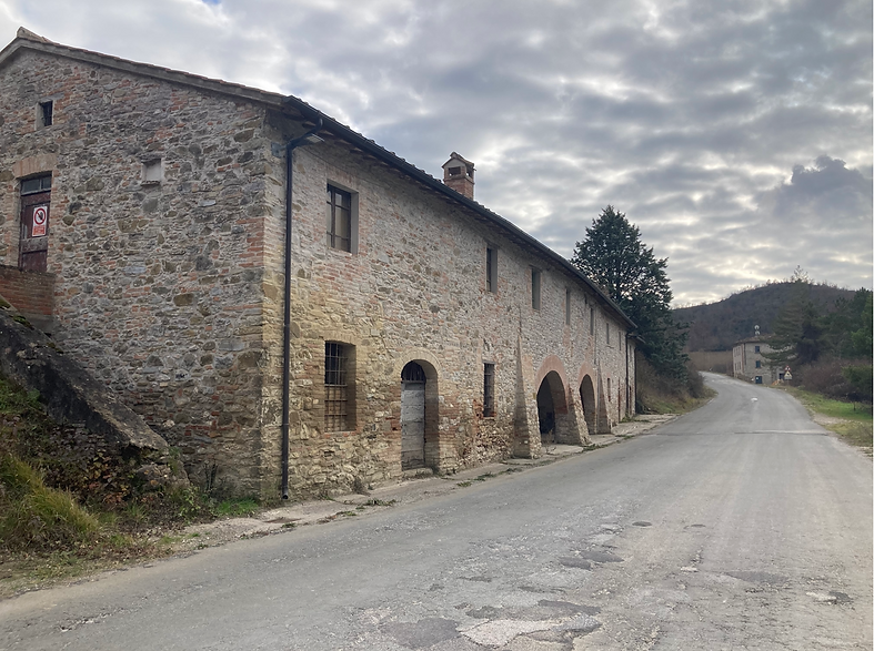
Immagine 4: l’ex Osteria e stazione di posta di Pian di Nese.
Fotografie: Francesco Deplanu
Carta: Carta corografica di Perugia del 1577, di Ignazio Danti, incisa da Mario Cartaro a Roma nel 1580 da Source gallica.bnf.fr / Bibliothèque nationale de France.
SOURCES:
- Giovanna Benni, researcher and teacher from Umberto I in “ Castle and rural lordships in the Upper Tiber valley between the Early and Late Middle Ages. The territory of Umbertide (Perugia, Italy) "published in NOTEBOOKS ON MEDIEVAL TOPOGRAPHY (Documentary and field research) Edited by Stefano Del Lungo N. 7, 2006.
- Photo by Giovanna Benni, Anna Boldrini, Fabio Mariotti, Francesco Deplanu.
- Photo: historical photos of Umbertide from the web and from various private archives to which we applied the " umbertidestoria " watermark in this way we try to avoid that further disclosure on our part favors purposes that are not consonant with our exclusively social and cultural intentions.